├── .gitignore
├── Makefile
├── README.md
├── build.sbt
├── data
├── README.md
└── botswana-training-set.json
├── docker
├── Dockerfile
├── log4j.properties
└── task.sh
├── project
├── Environment.scala
├── Version.scala
├── build.properties
└── plugins.sbt
├── sbt
├── src
└── main
│ ├── resources
│ ├── log4j.properties
│ ├── ne_50m_admin_0_countries.cpg
│ ├── ne_50m_admin_0_countries.dbf
│ ├── ne_50m_admin_0_countries.prj
│ ├── ne_50m_admin_0_countries.shp
│ └── ne_50m_admin_0_countries.shx
│ └── scala
│ ├── CountryGeometry.scala
│ ├── FootprintGenerator.scala
│ ├── LabeledPredictApp.scala
│ ├── LabeledTrainApp.scala
│ ├── MBTiles.scala
│ ├── OSM.scala
│ ├── Output.scala
│ ├── Predict.scala
│ ├── Train.scala
│ ├── Utils.scala
│ └── WorldPop.scala
└── view
├── africa.geojson
└── index.html
/.gitignore:
--------------------------------------------------------------------------------
1 | # Project generated files #
2 |
3 | metastore_db
4 | third_party_sources
5 | derby.log
6 |
7 | # Test Data #
8 | src/test-data
9 |
10 | # AWS #
11 |
12 | *.pem
13 |
14 | # Operating System Files #
15 |
16 | *.DS_Store
17 | Thumbs.db
18 |
19 | # Build Files #
20 |
21 | bin
22 | target
23 | build/
24 | .gradle
25 |
26 | # Eclipse Project Files #
27 |
28 | .classpath
29 | .project
30 | .settings
31 |
32 | # Vagrant
33 |
34 | .vagrant
35 |
36 | # Terraform
37 | deployment/terraform/.terraform
38 | deployment/terraform/terraform.tfvars
39 | .terraform.tfstate.lock.info
40 | *.tfvars
41 | *.tfstate
42 | *.tfplan
43 | *.tfstate.backup
44 | .terraform
45 |
46 | # Node and Webpack
47 | node_modules/
48 | npm-debug.log
49 | vendor.bundle.js
50 | dist/
51 |
52 |
53 | # IntelliJ IDEA Files #
54 |
55 | *.iml
56 | *.ipr
57 | *.iws
58 | *.idea
59 |
60 | # macOS
61 | .DS_Store
62 |
63 | # Emacs #
64 |
65 | .ensime
66 | \#*#
67 | *~
68 | .#*
69 |
70 | *.jar
71 |
72 | derby.log
73 |
--------------------------------------------------------------------------------
/Makefile:
--------------------------------------------------------------------------------
1 | WORKDIR := /hot-osm
2 |
3 | rwildcard=$(foreach d,$(wildcard $1*),$(call rwildcard,$d/,$2) $(filter $(subst *,%,$2),$d))
4 |
5 | SCALA_SRC := $(call rwildcard, src/, *.scala)
6 | SCALA_BLD := $(wildcard project/) build.sbt
7 | ASSEMBLY_JAR := target/scala-2.11/hot-osm-population-assembly.jar
8 | ECR_REPO := 670261699094.dkr.ecr.us-east-1.amazonaws.com/hotosm-population:latest
9 |
10 | .PHONY: train predict docker push-ecr
11 |
12 | ${ASSEMBLY_JAR}: ${SCALA_SRC} ${SCALA_BLD}
13 | ./sbt assembly
14 |
15 | docker/hot-osm-population-assembly.jar: ${ASSEMBLY_JAR}
16 | cp $< $@
17 |
18 | docker: docker/hot-osm-population-assembly.jar
19 | docker build docker -t hotosm-population
20 |
21 | push-ecr:
22 | docker tag hotosm-population:latest ${ECR_REPO}
23 | docker push ${ECR_REPO}
24 |
25 | train: ${ASSEMBLY_JAR}
26 | spark-submit --master "local[*]" --driver-memory 4G \
27 | --class com.azavea.hotosmpopulation.LabeledTrainApp \
28 | target/scala-2.11/hot-osm-population-assembly.jar \
29 | --country botswana \
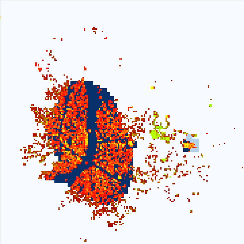
30 | --worldpop file:${WORKDIR}/WorldPop/BWA15v4.tif \
31 | --qatiles ${WORKDIR}/mbtiles/botswana.mbtiles \
32 | --training ${CURDIR}/data/botswana-training-set.json \
33 | --model ${WORKDIR}/models/botswana-regression
34 |
35 | predict: ${ASSEMBLY_JAR}
36 | spark-submit --master "local[*]" --driver-memory 4G \
37 | --class com.azavea.hotosmpopulation.LabeledPredictApp \
38 | target/scala-2.11/hot-osm-population-assembly.jar \
39 | --country botswana \
40 | --worldpop file:${WORKDIR}/WorldPop/BWA15v4.tif \
41 | --qatiles ${WORKDIR}/mbtiles/botswana.mbtiles \
42 | --model ${WORKDIR}/models/botswana-regression \
43 | --output ${WORKDIR}/botswana.json
--------------------------------------------------------------------------------
/README.md:
--------------------------------------------------------------------------------
1 | # HOTOSM WorldPop vs OSM Coverage
2 |
3 | This projects trains a model of population from WorldPop raster vs OSM building footprint from MapBox QA tiles in order to generate estimates of completeness for OSM building coverage.
4 |
5 | ## Building
6 |
7 | This project uses [Apache Spark](https://spark.apache.org/) and is expected to be run through [`spark-submit`](https://spark.apache.org/docs/latest/submitting-applications.html) command line tool.
8 |
9 | In order to generate the assembly `.jar` file required for this tool the following command is used:
10 |
11 | ```sh
12 | ./sbt assembly
13 | ```
14 |
15 | This will bootstrap the Scala Build Tool and built the assembly and requires only `java` version `1.8` to be available.
16 |
17 | ## Running
18 |
19 | Project defines multiple main files, for training a model of OSM based on WorldPop raster and for predicting OSM coverage based on trained model. They can be called through `spark-submit` as follows:
20 |
21 | ```sh
22 | spark-submit --master "local[*]" --driver-memory 4G \
23 | --class com.azavea.hotosmpopulation.TrainApp \
24 | target/scala-2.11/hot-osm-population-assembly.jar \
25 | --country botswana \
26 | --worldpop file:/hot-osm/WorldPop/BWA15v4.tif \
27 | --qatiles /hot-osm/mbtiles/botswana.mbtiles \
28 | --model /hot-osm/models/botswana-regression
29 |
30 | spark-submit --master "local[*]" --driver-memory 4G \
31 | --class com.azavea.hotosmpopulation.PredictApp \
32 | target/scala-2.11/hot-osm-population-assembly.jar \
33 | --country botswana \
34 | --worldpop file:/hot-osm/WorldPop/BWA15v4.tif \
35 | --qatiles /hot-osm/mbtiles/botswana.mbtiles \
36 | --model /hot-osm/models/botswana-regression \
37 | --output /hot-osm/botswana.json
38 | ```
39 |
40 | The arguments appearing before the `hot-osm-population-assembly.jar` are to `spark-submit` command.
41 | The arguments appearing after the JAR are specific to the application:
42 |
43 | `country`: `ADM0_A3` country code or name, used to lookup country boundary
44 | `worldpop`: URI to WorldPop raster, maybe `file:/` or `s3://` scheme.
45 | `qatiles`: Path to MapBox QA `.mbtiles` file for the country, must be local.
46 | `model`: Path to save/load model directory, is must be local.
47 | `output`: Path to generate prediction JSON output, must be local.
48 |
49 |
50 | For development the train and predict commands can are scripted through the `Makefile`:
51 |
52 | ```sh
53 | make train WORKDIR=/hot-osm
54 | make predict WORKDIR=/hot-osm
55 | ```
56 |
57 | ## `prediction.json`
58 | Because WorldPop and OSM have radically different resolutions for comparison to be valid they need to be aggregated to a common resolution. Specifically WorldPop will identify population centers and evenly spread estimated population for that center over each pixel. Whereas OSM building footprints are quite resolute and are covered can vary from pixel to pixel on 100m per pixel raster.
59 |
60 | Experimentally we see that aggregating the results per tile at zoom level 12 on WebMercator TMS layout produces visually useful relationship.
61 |
62 | The output of model prediction is saved as JSON where a record exist for every zoom level 12 TMS tile covering the country.
63 | The key is `"{zoom}/{column}/{row}"` following TMS endpoint convention.
64 |
65 | ```json
66 | {
67 | "12/2337/2337": {
68 | "index": 1.5921462086435942,
69 | "actual": {
70 | "pop_sum": 14.647022571414709,
71 | "osm_sum": 145.48814392089844,
72 | "osm_avg": 72.74407196044922
73 | },
74 | "prediction": {
75 | "osm_sum": 45872.07371520996,
76 | "osm_avg": 45.68931644941231
77 | }
78 | }
79 | }
80 | ```
81 |
82 | Units are:
83 | `pop`: estimated population
84 | `osm`: square meters of building footprint
85 |
86 | Why `_sum` and `_avg`? While visually the results are aggregated to one result per zoom 12 tile, training and prediction is happening at 16x16 pixels per zoom 12 tile.
87 | At this cell size there is enough smoothing between WorldPop and OSM to start building regressions.
88 |
89 | `index` is computed as `(predicted - actual) / predicted`, it will:
90 | - show negative for areas with low OSM coverage for WorldPop population coverage
91 | - show positive for areas with OSM coverage greater than WorldPop population coverage
92 | - stay close to `0` where the ratio of OSM/WorldPop coverage is average
93 |
94 | ## Docker
95 | Docker images suitable for AWS Batch can be built and pushed to ECR using:
96 |
97 | ```sh
98 | make docker
99 | aws ecr get-login --no-include-email --region us-east-1 --profile hotosm
100 | docker login -u AWS ... # copied from output of above command
101 | make push-ecr ECR_REPO=670261699094.dkr.ecr.us-east-1.amazonaws.com/hotosm-population:latest
102 | ```
103 |
104 | The `ENTRYPOINT` for docker images is `docker/task.sh` which handles the setup for the job.
105 | Note that `task.sh` uses positional arguments where all file references may refer use `s3://` scheme.
106 |
107 | The three arguments are are required in order:
108 |
109 | - `COMMAND`: `train` or `predict`
110 | - `COUNTRY`: Country name to download mbtiles
111 | - `WORLDPOP`: Name of WorldPop tiff or S3 URI to WorldPop tiff
112 |
113 | The container may be run locally with:
114 |
115 | ```sh
116 | docker run -it --rm -v ~/.aws:/root/.aws hotosm-population predict botswana s3://bucket/WorldPop/BWA15v4.tif
117 | # OR
118 | docker run -it --rm -v ~/.aws:/root/.aws hotosm-population predict botswana BWA15v4.tif
119 | ```
120 |
121 | ## Methodology
122 |
123 | Our core problem is to estimate the completeness of Open Street Map coverage of building footprints in areas where the map is known to be incomplete.
124 | In order to produce that expectation we need to correlate OSM building footprints with another data set.
125 | We assume population to be the driving factor for building construction so we use [WorldPop](http://www.worldpop.org.uk/) as the independent variable.
126 | Thus we're attempting to derive a relationship between population and building area used by that population.
127 |
128 | ### OpenStreetMap
129 |
130 | OSM geometries are sourced from [MapBox OSM QA tiles](https://osmlab.github.io/osm-qa-tiles/).
131 | They are rasterized to a layer with `CellSize(38.2185,38.2185)` in Web Mercator projection, `EPSG:3857`.
132 | This resolution corresponds to TMS zoom level 15 with 256x256 pixel tiles.
133 | The cell value is the area of the building footprint that intersects pixel footprint in square meters.
134 | If multiple buildings overlap a single pixel their footprints are combined.
135 |
136 | At this raster resolution resulting pixels cover buildings with sufficient precision:
137 |
138 | | Satellite | Rasterized Buildings |
139 | | ------------- |:--------------------:|
140 | | |
| |
141 |
142 |
143 | ### WorldPop
144 |
145 | WorldPop raster is provided in `EPSG:4326` with `CellSize(0.0008333, 0.0008333)`, this is close to 100m at equator.
146 | Because we're going to be predicting and reporting in `EPSG:3857` we reproject the raster using `SUM` resample method, aggregating population density values.
147 |
148 | Comparing WorldPop to OSM for Nata, Batswana reveals a problem:
149 |
150 | | WorldPop | WorldPop + OSM | OSM + Satellite |
151 | | ------------- |:--------------:|:---------------:|
152 | |
|
141 |
142 |
143 | ### WorldPop
144 |
145 | WorldPop raster is provided in `EPSG:4326` with `CellSize(0.0008333, 0.0008333)`, this is close to 100m at equator.
146 | Because we're going to be predicting and reporting in `EPSG:3857` we reproject the raster using `SUM` resample method, aggregating population density values.
147 |
148 | Comparing WorldPop to OSM for Nata, Batswana reveals a problem:
149 |
150 | | WorldPop | WorldPop + OSM | OSM + Satellite |
151 | | ------------- |:--------------:|:---------------:|
152 | | |
| |
| |
153 |
154 | Even though WorldPop raster resolution is ~100m the population density is spread evenly at `8.2 ppl/pixel` for the blue area.
155 | This makes it difficult to find relation between individual pixel of population and building area, which ranges from 26 to 982 in this area alone.
156 | The conclusion is that we must aggregate both population and building area to the point where they share resolution and aggregate trend may emerge.
157 |
158 | Plotting a sample of population vs building area we see this as stacks of multiple area values for single population area:
159 |
|
153 |
154 | Even though WorldPop raster resolution is ~100m the population density is spread evenly at `8.2 ppl/pixel` for the blue area.
155 | This makes it difficult to find relation between individual pixel of population and building area, which ranges from 26 to 982 in this area alone.
156 | The conclusion is that we must aggregate both population and building area to the point where they share resolution and aggregate trend may emerge.
157 |
158 | Plotting a sample of population vs building area we see this as stacks of multiple area values for single population area:
159 |  160 |
161 | Its until we reduce aggregate all values at TMS zoom 17 that a clear trend emerges:
162 |
160 |
161 | Its until we reduce aggregate all values at TMS zoom 17 that a clear trend emerges:
162 |  163 |
164 | Finding line of best fit for gives us 6.5 square meters of building footprint per person in Botswana with R-squared value of `0.88069`.
165 | Aggregating to larger areas does not significantly change the fit or the slope of the line.
166 |
167 | ### Data Quality
168 |
169 | Following data quality issues have been encountered and considered:
170 |
171 | Estimates of WorldPop population depend on administrative census data. These estimates data varies in quality and recency from country to country.
172 | To avoid training on data from various sources we fit a model per country where sources are most likely to be consistent, rather than larger areas.
173 |
174 | WorldPop and OSM are updated at different intervals and do not share coverage. This leads to following problems:
175 |
176 | - Regions in WorldPop showing population that are not covered by OSM
177 | - Regions in OSM showing building footprints not covered by WorldPop
178 | - Incomplete OSM coverage per Region
179 |
180 | To address above concerns we mark regions where OSM/WorldPop relation appears optimal, this allows us to compare other areas and reveal the above problems using the derived model. For further discussion and examples see [training set](azavea/hot-osm-population/blob/master/data/README.md) documentation.
181 |
182 | ### Workflow
183 |
184 | Overall workflow as follows:
185 |
186 | **Preparation**
187 |
188 | - Read WorldPop raster for country
189 | - Reproject WorldPop to `EPSG:3857` TMS Level 15 at `256x256` pixel tiles.
190 | - Rasterize OSM building footprints to `EPSG:3857` TMS Level 15 at `256x256` pixel tiles.
191 | - Aggregate both population and building area to `4x4` tile using `SUM` resample method.
192 |
193 | **Training**
194 |
195 | - Mask WorldPop and OSM raster by training set polygons.
196 | - Set all OSM `NODATA` cell values to `0.0`.
197 | - Fit and save `LinearRegressionModel` to population vs. building area.
198 | - Fix y-intercept at '0.0'.
199 |
200 | **Prediction**
201 | - Apply `LinearRegressionModel` to get expected building area.
202 | - Sum all of `4x4` pixel in a tile.
203 | - Report
204 | - Total population
205 | - Actual building area
206 | - Expected building area
207 | - Completeness index as `(actual area - expect area) / expected area`
208 |
209 | Because the model is derived from well labeled areas which we expect it to be stable in describing the usage building space per country.
210 | This enables us to re-run the prediction process with updated OSM input and track changes in OSM coverage.
211 |
212 |
213 |
--------------------------------------------------------------------------------
/build.sbt:
--------------------------------------------------------------------------------
1 | name := "hotosmpopulation"
2 |
3 | version := "0.0.1"
4 |
5 | description := "Estimate OSM coverage from World Population raster"
6 |
7 | organization := "com.azavea"
8 |
9 | organizationName := "Azavea"
10 |
11 | scalaVersion in ThisBuild := Version.scala
12 |
13 | val common = Seq(
14 | resolvers ++= Seq(
15 | "locationtech-releases" at "https://repo.locationtech.org/content/groups/releases",
16 | //"locationtech-snapshots" at "https://repo.locationtech.org/content/groups/snapshots",
17 | Resolver.bintrayRepo("azavea", "maven"),
18 | Resolver.bintrayRepo("s22s", "maven"),
19 | "Geotools" at "http://download.osgeo.org/webdav/geotools/"
20 | ),
21 |
22 | scalacOptions := Seq(
23 | "-deprecation",
24 | "-Ypartial-unification",
25 | "-Ywarn-value-discard",
26 | "-Ywarn-dead-code",
27 | "-Ywarn-numeric-widen"
28 | ),
29 |
30 | scalacOptions in (Compile, doc) += "-groups",
31 |
32 | libraryDependencies ++= Seq(
33 | //"io.astraea" %% "raster-frames" % "0.6.2-SNAPSHOT",
34 | "io.astraea" %% "raster-frames" % "0.6.1",
35 | "org.geotools" % "gt-shapefile" % Version.geotools,
36 | // This is one finicky dependency. Being explicit in hopes it will stop hurting Travis.
37 | "javax.media" % "jai_core" % "1.1.3" from "http://download.osgeo.org/webdav/geotools/javax/media/jai_core/1.1.3/jai_core-1.1.3.jar",
38 | "org.apache.spark" %% "spark-hive" % Version.spark % Provided,
39 | "org.apache.spark" %% "spark-core" % Version.spark % Provided,
40 | "org.apache.spark" %% "spark-sql" % Version.spark % Provided,
41 | "org.apache.spark" %% "spark-mllib" % Version.spark % Provided,
42 | "org.locationtech.geotrellis" %% "geotrellis-proj4" % Version.geotrellis,
43 | "org.locationtech.geotrellis" %% "geotrellis-vector" % Version.geotrellis,
44 | "org.locationtech.geotrellis" %% "geotrellis-raster" % Version.geotrellis,
45 | "org.locationtech.geotrellis" %% "geotrellis-shapefile" % Version.geotrellis,
46 | "org.locationtech.geotrellis" %% "geotrellis-spark" % Version.geotrellis,
47 | "org.locationtech.geotrellis" %% "geotrellis-util" % Version.geotrellis,
48 | "org.locationtech.geotrellis" %% "geotrellis-s3" % Version.geotrellis,
49 | "org.locationtech.geotrellis" %% "geotrellis-vectortile" % Version.geotrellis,
50 | "com.amazonaws" % "aws-java-sdk-s3" % "1.11.143",
51 | "org.scalatest" %% "scalatest" % "3.0.1" % Test,
52 | "org.spire-math" %% "spire" % Version.spire,
53 | "org.typelevel" %% "cats-core" % "1.0.0-RC1",
54 | "com.monovore" %% "decline" % "0.4.0-RC1",
55 | "org.tpolecat" %% "doobie-core" % "0.5.2",
56 | "org.xerial" % "sqlite-jdbc" % "3.21.0"
57 | ),
58 |
59 | parallelExecution in Test := false
60 | )
61 |
62 | fork in console := true
63 | javaOptions += "-Xmx8G -XX:+UseParallelGC"
64 |
65 | val release = Seq(
66 | licenses += ("Apache-2.0", url("http://apache.org/licenses/LICENSE-2.0"))
67 | )
68 |
69 | assemblyJarName in assembly := "hot-osm-population-assembly.jar"
70 |
71 | val MetaInfDiscardRx = """^META-INF(.+)\.(SF|RSA|MF)$""".r
72 |
73 | assemblyMergeStrategy in assembly := {
74 | case s if s.startsWith("META-INF/services") => MergeStrategy.concat
75 | case "reference.conf" | "application.conf" => MergeStrategy.concat
76 | case MetaInfDiscardRx(_*) => MergeStrategy.discard
77 | case _ => MergeStrategy.first
78 | }
79 |
80 | lazy val root = Project("hot-osm-population", file(".")).
81 | settings(common, release).
82 | settings(
83 | initialCommands in console :=
84 | """
85 | |import geotrellis.proj4._
86 | |import geotrellis.raster._
87 | |import geotrellis.raster.resample._
88 | |import geotrellis.spark._
89 | |import geotrellis.spark.tiling._
90 | |import geotrellis.vector._
91 | |import com.azavea.hotosmpopulation._
92 | |import com.azavea.hotosmpopulation.Utils._
93 | |import astraea.spark.rasterframes._
94 | |import astraea.spark.rasterframes.ml.TileExploder
95 | |import org.apache.spark.sql._
96 | |import org.apache.spark.sql.functions._
97 | |import org.apache.spark.ml.regression._
98 | |import org.apache.spark.storage.StorageLevel
99 | |import geotrellis.spark._
100 | |
101 | |implicit val spark: SparkSession = SparkSession.builder().
102 | | master("local[8]").appName("RasterFrames").
103 | | config("spark.ui.enabled", "true").
104 | | config("spark.driver.maxResultSize", "2G").
105 | | getOrCreate().
106 | | withRasterFrames
107 | |
108 | |import spark.implicits._
109 | """.stripMargin
110 | )
111 |
--------------------------------------------------------------------------------
/data/README.md:
--------------------------------------------------------------------------------
1 | # Training Data
2 |
3 | We aim to derive relationship between population density in WorldPop raster `(population / pixel)` and Open Street Map building footprint coverage `(square meters / pixel)`.
4 | This relationship can break down because OSM and WorldPop have different biases and different update intervals.
5 |
6 | In order to avoid training on regions that have this problem we need to identify training regions.
7 | The training sets are consumed as GeoJSON `FeatureCollection` of `MultiPolygon`s in `epsg:3857` projection.
8 |
9 | ## Generation
10 |
11 | A good technique for generating a training set is to use QGIS with following layers:
12 |
13 | - WorldPop Raster
14 | - Rasterized OSM Building Footprints or OSM WMS with building footprints
15 | - MapBox Satellite Streets WMS layer
16 |
17 | Following are examples of areas labeled for training:
18 |
19 | **Legend**:
20 | - `WorldPop`: light-blue to deep-blue
21 | - `OSM Building`: green/orange/yellow
22 | - `Training Area`: green polygon
23 |
24 | ### Good OSM/WorldPop Coverage
25 | WorldPop has detected high population density area and OSM building coverage looks complete.
26 |
163 |
164 | Finding line of best fit for gives us 6.5 square meters of building footprint per person in Botswana with R-squared value of `0.88069`.
165 | Aggregating to larger areas does not significantly change the fit or the slope of the line.
166 |
167 | ### Data Quality
168 |
169 | Following data quality issues have been encountered and considered:
170 |
171 | Estimates of WorldPop population depend on administrative census data. These estimates data varies in quality and recency from country to country.
172 | To avoid training on data from various sources we fit a model per country where sources are most likely to be consistent, rather than larger areas.
173 |
174 | WorldPop and OSM are updated at different intervals and do not share coverage. This leads to following problems:
175 |
176 | - Regions in WorldPop showing population that are not covered by OSM
177 | - Regions in OSM showing building footprints not covered by WorldPop
178 | - Incomplete OSM coverage per Region
179 |
180 | To address above concerns we mark regions where OSM/WorldPop relation appears optimal, this allows us to compare other areas and reveal the above problems using the derived model. For further discussion and examples see [training set](azavea/hot-osm-population/blob/master/data/README.md) documentation.
181 |
182 | ### Workflow
183 |
184 | Overall workflow as follows:
185 |
186 | **Preparation**
187 |
188 | - Read WorldPop raster for country
189 | - Reproject WorldPop to `EPSG:3857` TMS Level 15 at `256x256` pixel tiles.
190 | - Rasterize OSM building footprints to `EPSG:3857` TMS Level 15 at `256x256` pixel tiles.
191 | - Aggregate both population and building area to `4x4` tile using `SUM` resample method.
192 |
193 | **Training**
194 |
195 | - Mask WorldPop and OSM raster by training set polygons.
196 | - Set all OSM `NODATA` cell values to `0.0`.
197 | - Fit and save `LinearRegressionModel` to population vs. building area.
198 | - Fix y-intercept at '0.0'.
199 |
200 | **Prediction**
201 | - Apply `LinearRegressionModel` to get expected building area.
202 | - Sum all of `4x4` pixel in a tile.
203 | - Report
204 | - Total population
205 | - Actual building area
206 | - Expected building area
207 | - Completeness index as `(actual area - expect area) / expected area`
208 |
209 | Because the model is derived from well labeled areas which we expect it to be stable in describing the usage building space per country.
210 | This enables us to re-run the prediction process with updated OSM input and track changes in OSM coverage.
211 |
212 |
213 |
--------------------------------------------------------------------------------
/build.sbt:
--------------------------------------------------------------------------------
1 | name := "hotosmpopulation"
2 |
3 | version := "0.0.1"
4 |
5 | description := "Estimate OSM coverage from World Population raster"
6 |
7 | organization := "com.azavea"
8 |
9 | organizationName := "Azavea"
10 |
11 | scalaVersion in ThisBuild := Version.scala
12 |
13 | val common = Seq(
14 | resolvers ++= Seq(
15 | "locationtech-releases" at "https://repo.locationtech.org/content/groups/releases",
16 | //"locationtech-snapshots" at "https://repo.locationtech.org/content/groups/snapshots",
17 | Resolver.bintrayRepo("azavea", "maven"),
18 | Resolver.bintrayRepo("s22s", "maven"),
19 | "Geotools" at "http://download.osgeo.org/webdav/geotools/"
20 | ),
21 |
22 | scalacOptions := Seq(
23 | "-deprecation",
24 | "-Ypartial-unification",
25 | "-Ywarn-value-discard",
26 | "-Ywarn-dead-code",
27 | "-Ywarn-numeric-widen"
28 | ),
29 |
30 | scalacOptions in (Compile, doc) += "-groups",
31 |
32 | libraryDependencies ++= Seq(
33 | //"io.astraea" %% "raster-frames" % "0.6.2-SNAPSHOT",
34 | "io.astraea" %% "raster-frames" % "0.6.1",
35 | "org.geotools" % "gt-shapefile" % Version.geotools,
36 | // This is one finicky dependency. Being explicit in hopes it will stop hurting Travis.
37 | "javax.media" % "jai_core" % "1.1.3" from "http://download.osgeo.org/webdav/geotools/javax/media/jai_core/1.1.3/jai_core-1.1.3.jar",
38 | "org.apache.spark" %% "spark-hive" % Version.spark % Provided,
39 | "org.apache.spark" %% "spark-core" % Version.spark % Provided,
40 | "org.apache.spark" %% "spark-sql" % Version.spark % Provided,
41 | "org.apache.spark" %% "spark-mllib" % Version.spark % Provided,
42 | "org.locationtech.geotrellis" %% "geotrellis-proj4" % Version.geotrellis,
43 | "org.locationtech.geotrellis" %% "geotrellis-vector" % Version.geotrellis,
44 | "org.locationtech.geotrellis" %% "geotrellis-raster" % Version.geotrellis,
45 | "org.locationtech.geotrellis" %% "geotrellis-shapefile" % Version.geotrellis,
46 | "org.locationtech.geotrellis" %% "geotrellis-spark" % Version.geotrellis,
47 | "org.locationtech.geotrellis" %% "geotrellis-util" % Version.geotrellis,
48 | "org.locationtech.geotrellis" %% "geotrellis-s3" % Version.geotrellis,
49 | "org.locationtech.geotrellis" %% "geotrellis-vectortile" % Version.geotrellis,
50 | "com.amazonaws" % "aws-java-sdk-s3" % "1.11.143",
51 | "org.scalatest" %% "scalatest" % "3.0.1" % Test,
52 | "org.spire-math" %% "spire" % Version.spire,
53 | "org.typelevel" %% "cats-core" % "1.0.0-RC1",
54 | "com.monovore" %% "decline" % "0.4.0-RC1",
55 | "org.tpolecat" %% "doobie-core" % "0.5.2",
56 | "org.xerial" % "sqlite-jdbc" % "3.21.0"
57 | ),
58 |
59 | parallelExecution in Test := false
60 | )
61 |
62 | fork in console := true
63 | javaOptions += "-Xmx8G -XX:+UseParallelGC"
64 |
65 | val release = Seq(
66 | licenses += ("Apache-2.0", url("http://apache.org/licenses/LICENSE-2.0"))
67 | )
68 |
69 | assemblyJarName in assembly := "hot-osm-population-assembly.jar"
70 |
71 | val MetaInfDiscardRx = """^META-INF(.+)\.(SF|RSA|MF)$""".r
72 |
73 | assemblyMergeStrategy in assembly := {
74 | case s if s.startsWith("META-INF/services") => MergeStrategy.concat
75 | case "reference.conf" | "application.conf" => MergeStrategy.concat
76 | case MetaInfDiscardRx(_*) => MergeStrategy.discard
77 | case _ => MergeStrategy.first
78 | }
79 |
80 | lazy val root = Project("hot-osm-population", file(".")).
81 | settings(common, release).
82 | settings(
83 | initialCommands in console :=
84 | """
85 | |import geotrellis.proj4._
86 | |import geotrellis.raster._
87 | |import geotrellis.raster.resample._
88 | |import geotrellis.spark._
89 | |import geotrellis.spark.tiling._
90 | |import geotrellis.vector._
91 | |import com.azavea.hotosmpopulation._
92 | |import com.azavea.hotosmpopulation.Utils._
93 | |import astraea.spark.rasterframes._
94 | |import astraea.spark.rasterframes.ml.TileExploder
95 | |import org.apache.spark.sql._
96 | |import org.apache.spark.sql.functions._
97 | |import org.apache.spark.ml.regression._
98 | |import org.apache.spark.storage.StorageLevel
99 | |import geotrellis.spark._
100 | |
101 | |implicit val spark: SparkSession = SparkSession.builder().
102 | | master("local[8]").appName("RasterFrames").
103 | | config("spark.ui.enabled", "true").
104 | | config("spark.driver.maxResultSize", "2G").
105 | | getOrCreate().
106 | | withRasterFrames
107 | |
108 | |import spark.implicits._
109 | """.stripMargin
110 | )
111 |
--------------------------------------------------------------------------------
/data/README.md:
--------------------------------------------------------------------------------
1 | # Training Data
2 |
3 | We aim to derive relationship between population density in WorldPop raster `(population / pixel)` and Open Street Map building footprint coverage `(square meters / pixel)`.
4 | This relationship can break down because OSM and WorldPop have different biases and different update intervals.
5 |
6 | In order to avoid training on regions that have this problem we need to identify training regions.
7 | The training sets are consumed as GeoJSON `FeatureCollection` of `MultiPolygon`s in `epsg:3857` projection.
8 |
9 | ## Generation
10 |
11 | A good technique for generating a training set is to use QGIS with following layers:
12 |
13 | - WorldPop Raster
14 | - Rasterized OSM Building Footprints or OSM WMS with building footprints
15 | - MapBox Satellite Streets WMS layer
16 |
17 | Following are examples of areas labeled for training:
18 |
19 | **Legend**:
20 | - `WorldPop`: light-blue to deep-blue
21 | - `OSM Building`: green/orange/yellow
22 | - `Training Area`: green polygon
23 |
24 | ### Good OSM/WorldPop Coverage
25 | WorldPop has detected high population density area and OSM building coverage looks complete.
26 |  27 |
28 | Visually verify with MapBox satellite streets layer that OSM coverage is good
29 |
27 |
28 | Visually verify with MapBox satellite streets layer that OSM coverage is good
29 |  30 |
31 | Label city and surrounding area as training area
32 |
30 |
31 | Label city and surrounding area as training area
32 |  33 |
34 | ### OSM newer than WorldPop raster
35 | OSM building footprints but WorldPop is shows no change in population density.
36 |
33 |
34 | ### OSM newer than WorldPop raster
35 | OSM building footprints but WorldPop is shows no change in population density.
36 |  37 |
38 | Satellite verifies that something really is there.
39 |
37 |
38 | Satellite verifies that something really is there.
39 |  40 |
41 | Do not label this, it would indicate that no population implies building coverage for our training set.
42 |
43 | ### Partial OSM Coverage over WorldPop
44 | Here we have a high population density area that is partially mapped.
45 |
40 |
41 | Do not label this, it would indicate that no population implies building coverage for our training set.
42 |
43 | ### Partial OSM Coverage over WorldPop
44 | Here we have a high population density area that is partially mapped.
45 |  46 |
47 | Satellite show lots of unlabelled buildings.
48 |
46 |
47 | Satellite show lots of unlabelled buildings.
48 |  49 |
50 | Draw training area around well lebeled blocks of the city to capture example of dense urban region.
51 |
52 | ### OSM Coverage in Low density Area, WorldPop mislabels farms
53 | Here we have example of low density area
54 |
49 |
50 | Draw training area around well lebeled blocks of the city to capture example of dense urban region.
51 |
52 | ### OSM Coverage in Low density Area, WorldPop mislabels farms
53 | Here we have example of low density area
54 |  55 |
56 | WorldPop labelled the surrounding farmland at same density as city center
57 |
55 |
56 | WorldPop labelled the surrounding farmland at same density as city center
57 |  58 |
59 | Label the city and surround areas
60 |
58 |
59 | Label the city and surround areas
60 |  61 |
62 |
63 |
--------------------------------------------------------------------------------
/data/botswana-training-set.json:
--------------------------------------------------------------------------------
1 | {
2 | "type": "FeatureCollection",
3 | "name": "worldpop-osm-botswana-training",
4 | "crs": { "type": "name", "properties": { "name": "urn:ogc:def:crs:EPSG::3857" } },
5 | "features": [
6 | { "type": "Feature", "properties": { }, "geometry": { "type": "MultiPolygon", "coordinates": [ [ [ [ 2965856.483420270495117, -2551922.143000584561378 ], [ 2979284.343173592351377, -2551568.061506075318903 ], [ 2986011.891569272615016, -2564778.024955083616078 ], [ 2978739.602412808220834, -2568809.106584883760661 ], [ 2965257.268583408091217, -2567120.410226454026997 ], [ 2964058.83890968374908, -2557396.787646462209523 ], [ 2965856.483420270495117, -2551922.143000584561378 ] ], [ [ 2973688.834171415306628, -2557723.63210293231532 ], [ 2973753.522136758547276, -2557066.538560236804187 ], [ 2975323.056453767698258, -2557144.845044599846005 ], [ 2975510.311090286355466, -2557223.151528961956501 ], [ 2976211.664819795638323, -2557413.810795236378908 ], [ 2976065.26574033498764, -2557948.337666755542159 ], [ 2975544.357387835625559, -2557941.528407245874405 ], [ 2975367.316640581004322, -2558486.269168030004948 ], [ 2974298.262897542212158, -2558503.292316804174334 ], [ 2973205.376746219582856, -2558390.939534892793745 ], [ 2973317.729528131429106, -2558138.996933029964566 ], [ 2973770.545285532716662, -2557832.580255088862032 ], [ 2973688.834171415306628, -2557723.63210293231532 ] ], [ [ 2976119.739816414192319, -2556664.79224915895611 ], [ 2976259.329636364709586, -2556899.711702247150242 ], [ 2976582.769463080447167, -2556903.116332001984119 ], [ 2976667.885206952691078, -2556399.231128277257085 ], [ 2976211.664819796103984, -2556273.259827345609665 ], [ 2976119.739816414192319, -2556664.79224915895611 ] ], [ [ 2972146.536892445757985, -2556692.02928719855845 ], [ 2973511.793424160219729, -2556664.792249159421772 ], [ 2973504.984164650551975, -2556937.162629551254213 ], [ 2973144.093410631176084, -2557127.82189582567662 ], [ 2972980.671182395890355, -2557216.342269453220069 ], [ 2972071.635037838015705, -2557284.434864551294595 ], [ 2972146.536892445757985, -2556692.02928719855845 ] ], [ [ 2970961.725737741217017, -2557577.233023472130299 ], [ 2971605.20076141692698, -2557801.938587295357138 ], [ 2971550.726685338653624, -2557944.933037001173943 ], [ 2971155.789633770473301, -2558121.973784256260842 ], [ 2970709.783135878387839, -2557822.366365824826062 ], [ 2970961.725737741217017, -2557577.233023472130299 ] ], [ [ 2969639.878235401585698, -2557274.220975285861641 ], [ 2969730.100923906546086, -2557623.195525163318962 ], [ 2969961.61574723944068, -2557618.088580530602485 ], [ 2970097.800937435589731, -2557362.741348913405091 ], [ 2969757.337961945682764, -2557165.272823129314929 ], [ 2969639.878235401585698, -2557274.220975285861641 ] ], [ [ 2975701.821514002047479, -2562912.287849399726838 ], [ 2976280.608572335448116, -2562980.380444497801363 ], [ 2976471.267838609870523, -2562789.721178223378956 ], [ 2976675.545623903628439, -2562789.721178223378956 ], [ 2976593.834509786218405, -2563211.895267831161618 ], [ 2976518.932655178476125, -2563375.317496066447347 ], [ 2976675.545623903628439, -2563484.265648222994059 ], [ 2976730.019699982367456, -2565629.18239381024614 ], [ 2975531.590026257093996, -2564131.145301654469222 ], [ 2975681.393735473044217, -2563817.919364203233272 ], [ 2975470.306690669152886, -2563470.647129203658551 ], [ 2975626.919659394305199, -2563286.797122438903898 ], [ 2975953.764115864876658, -2563205.086008321493864 ], [ 2975701.821514002047479, -2562912.287849399726838 ] ], [ [ 2973761.182553709018975, -2563443.410091164521873 ], [ 2974823.427037238143384, -2563123.374894203618169 ], [ 2975320.502981453202665, -2563538.739724301733077 ], [ 2974966.42148694396019, -2563743.017509595490992 ], [ 2975300.075202924199402, -2564519.27309371298179 ], [ 2974755.334442140068859, -2564383.087903516832739 ], [ 2974632.767770963720977, -2564492.036055673845112 ], [ 2973761.182553709018975, -2563443.410091164521873 ] ], [ [ 2976689.164142923429608, -2563279.987862929236144 ], [ 2977002.390080374199897, -2563320.843419988173991 ], [ 2977070.482675472274423, -2563443.410091164521873 ], [ 2977431.373429491650313, -2563538.739724301733077 ], [ 2977451.801208021119237, -2564614.602726850192994 ], [ 2978051.016044883523136, -2563981.341592438519001 ], [ 2977935.258633216843009, -2562782.911918713711202 ], [ 2977090.910454001743346, -2562823.76747577264905 ], [ 2976873.014149688184261, -2562428.830424204003066 ], [ 2976689.164142923429608, -2563279.987862929236144 ] ], [ [ 2975184.317791257519275, -2562347.119310086593032 ], [ 2975586.064102335833013, -2562755.674880674574524 ], [ 2976205.706717727705836, -2562612.680430968757719 ], [ 2976471.267838609870523, -2562490.113759792409837 ], [ 2976348.701167433522642, -2562299.45449351798743 ], [ 2975667.775216453243047, -2562210.934119890443981 ], [ 2975184.317791257519275, -2562347.119310086593032 ] ], [ [ 2979573.736702762544155, -2563891.118903934024274 ], [ 2979696.303373938892037, -2564080.075855331029743 ], [ 2979682.684854919556528, -2564248.605028198566288 ], [ 2979641.829297860618681, -2564357.553180355113 ], [ 2979689.494114429224283, -2564721.848564129788429 ], [ 2979650.340872247703373, -2564842.712920428719372 ], [ 2979240.082986782304943, -2564541.403187119867653 ], [ 2979427.337623301893473, -2564189.024007487576455 ], [ 2979292.85474798316136, -2564129.442986777052283 ], [ 2979573.736702762544155, -2563891.118903934024274 ] ] ] ] } },
7 | { "type": "Feature", "properties": { }, "geometry": { "type": "MultiPolygon", "coordinates": [ [ [ [ 2982285.52430254034698, -2540058.710619629360735 ], [ 2985717.391095479950309, -2540821.347684727050364 ], [ 2985499.494791166391224, -2546268.755292567890137 ], [ 2981386.7020472465083, -2546500.270115900784731 ], [ 2977764.175988032482564, -2544757.099681391846389 ], [ 2980269.983487639110535, -2540508.121747276280075 ], [ 2980304.242574549280107, -2540489.396283620968461 ], [ 2982285.52430254034698, -2540058.710619629360735 ] ], [ [ 2981648.007380935363472, -2543798.696405387017876 ], [ 2982136.57175076380372, -2543905.942242666613311 ], [ 2982037.83748787175864, -2544307.688553744927049 ], [ 2981799.513405028730631, -2544278.749200827907771 ], [ 2981571.403211450204253, -2544464.301522470079362 ], [ 2981290.521256670821458, -2544181.717252813279629 ], [ 2981096.457360641565174, -2543883.812149259727448 ], [ 2981648.007380935363472, -2543798.696405387017876 ] ] ] ] } },
8 | { "type": "Feature", "properties": { }, "geometry": { "type": "MultiPolygon", "coordinates": [ [ [ [ 2916059.73025692300871, -2523071.736036244314164 ], [ 2932510.901232626289129, -2527810.980655072722584 ], [ 2933545.908678117208183, -2552487.737118627410382 ], [ 2911756.278246722649783, -2549600.611086467746645 ], [ 2906254.39656279515475, -2534402.343860569875687 ], [ 2907561.774388678837568, -2522635.943427616264671 ], [ 2916059.73025692300871, -2523071.736036244314164 ] ] ] ] } },
9 | { "type": "Feature", "properties": { }, "geometry": { "type": "MultiPolygon", "coordinates": [ [ [ [ 2601174.166961751878262, -2267803.772518157958984 ], [ 2600670.558589624240994, -2279084.600053811911494 ], [ 2608879.375055301003158, -2280192.53847249224782 ], [ 2624049.485501368995756, -2261508.95763139706105 ], [ 2619316.990628585685045, -2259537.918540618382394 ], [ 2607872.158311046194285, -2260098.564424608834088 ], [ 2601174.166961751878262, -2267803.772518157958984 ] ] ] ] } },
10 | { "type": "Feature", "properties": { }, "geometry": { "type": "MultiPolygon", "coordinates": [ [ [ [ 2845092.974974212702364, -2434257.324267356656492 ], [ 2853481.934443594887853, -2435533.795591179281473 ], [ 2853824.340952549595386, -2446873.493505374528468 ], [ 2847006.42311248742044, -2447510.470319826621562 ], [ 2841044.521544810850173, -2440521.349225286860019 ], [ 2845092.974974212702364, -2434257.324267356656492 ] ] ] ] } },
11 | { "type": "Feature", "properties": { }, "geometry": { "type": "MultiPolygon", "coordinates": [ [ [ [ 2411073.118736115749925, -2471000.188248161226511 ], [ 2416074.644180927425623, -2475153.079411723185331 ], [ 2414431.543764039874077, -2481328.248011454474181 ], [ 2405999.369097155053169, -2481237.967768768314272 ], [ 2402893.728748752269894, -2473040.521732867695391 ], [ 2406757.723135718610138, -2470368.226549358572811 ], [ 2411073.118736115749925, -2471000.188248161226511 ] ] ] ] } },
12 | { "type": "Feature", "properties": { }, "geometry": { "type": "MultiPolygon", "coordinates": [ [ [ [ 2534183.777684851083905, -2706992.825551418587565 ], [ 2546124.341757350601256, -2706539.723789738956839 ], [ 2546230.953936569392681, -2721225.551477121189237 ], [ 2529252.964395984075963, -2721198.89843231625855 ], [ 2528959.780903132166713, -2709471.558718254324049 ], [ 2534183.777684851083905, -2706992.825551418587565 ] ] ] ] } },
13 | { "type": "Feature", "properties": { }, "geometry": { "type": "MultiPolygon", "coordinates": [ [ [ [ 2439812.009292653296143, -2670911.266147072892636 ], [ 2493970.996335779316723, -2673363.346269104164094 ], [ 2491732.140572185162455, -2701722.185941291972995 ], [ 2439598.784934215713292, -2699376.717998479492962 ], [ 2439812.009292653296143, -2670911.266147072892636 ] ] ] ] } },
14 | { "type": "Feature", "properties": { }, "geometry": { "type": "MultiPolygon", "coordinates": [ [ [ [ 3161515.205022294074297, -2501604.432672 ], [ 3170052.649105143733323, -2505013.268259037286043 ], [ 3170175.490027199033648, -2514533.439718329813331 ], [ 3160993.1311035589315, -2514410.598796274513006 ], [ 3156048.783990829717368, -2509189.859608920291066 ], [ 3157338.613672411069274, -2503846.279499511234462 ], [ 3161515.205022294074297, -2501604.432672 ] ], [ [ 3163480.899698857218027, -2510004.160564889200032 ], [ 3163976.102165893185884, -2510098.210645837709308 ], [ 3163876.293916723225266, -2510514.718147182371467 ], [ 3163417.559848422184587, -2510510.879368368070573 ], [ 3163480.899698857218027, -2510004.160564889200032 ] ] ] ] } },
15 | { "type": "Feature", "properties": { }, "geometry": { "type": "MultiPolygon", "coordinates": [ [ [ [ 3183837.943750750739127, -2516677.87753343814984 ], [ 3187584.591873444616795, -2518535.846479528117925 ], [ 3187077.873069965280592, -2522973.474788784515113 ], [ 3180398.397933195345104, -2523894.781704201363027 ], [ 3178325.457373508252203, -2519134.695974549278617 ], [ 3180275.557011140044779, -2515802.635963792447001 ], [ 3183837.943750750739127, -2516677.87753343814984 ] ] ] ] } },
16 | { "type": "Feature", "properties": { }, "geometry": { "type": "MultiPolygon", "coordinates": [ [ [ [ 3196841.806983976159245, -2487779.550619865767658 ], [ 3200818.781835524830967, -2488823.698457337915897 ], [ 3201463.696676316671073, -2493783.400685331318527 ], [ 3198807.261736865155399, -2496332.349817984271795 ], [ 3193924.33508515637368, -2494858.258753317408264 ], [ 3194062.531122468877584, -2489161.510992990806699 ], [ 3196841.806983976159245, -2487779.550619865767658 ] ] ] ] } },
17 | { "type": "Feature", "properties": { }, "geometry": { "type": "MultiPolygon", "coordinates": [ [ [ [ 3100771.56868416024372, -2498372.66075775353238 ], [ 3109124.751383941620588, -2501259.422426060307771 ], [ 3108080.603546469006687, -2514956.18523526052013 ], [ 3097700.54563277028501, -2518150.049208706244826 ], [ 3088426.056017571594566, -2510165.389275092165917 ], [ 3094875.204425490926951, -2501935.047497366089374 ], [ 3100771.56868416024372, -2498372.66075775353238 ] ], [ [ 3097940.46930865989998, -2509931.223767423070967 ], [ 3098178.473595142364502, -2510111.646371692419052 ], [ 3098040.277557829860598, -2510388.03844631742686 ], [ 3097809.950828975532204, -2510242.164851376321167 ], [ 3097940.46930865989998, -2509931.223767423070967 ] ] ] ] } },
18 | { "type": "Feature", "properties": { }, "geometry": { "type": "MultiPolygon", "coordinates": [ [ [ [ 3084003.78282356960699, -2500952.320120921358466 ], [ 3088794.578783738426864, -2503409.138562033418566 ], [ 3096902.079639408737421, -2496652.887848975136876 ], [ 3092725.488289517816156, -2489466.693908722139895 ], [ 3086829.124030848965049, -2490633.682668250519782 ], [ 3082529.691758902277797, -2495731.5809335578233 ], [ 3084003.78282356960699, -2500952.320120921358466 ] ] ] ] } },
19 | { "type": "Feature", "properties": { }, "geometry": { "type": "MultiPolygon", "coordinates": [ [ [ [ 3038289.643880755640566, -2377125.833423872012645 ], [ 3041443.288716884795576, -2377198.331006311811507 ], [ 3043890.08212422626093, -2385263.687052733730525 ], [ 3039395.232012961991131, -2386061.160459571052343 ], [ 3036150.965198783203959, -2381892.549469285644591 ], [ 3036585.950693421531469, -2377687.689687780104578 ], [ 3036984.687396840192378, -2377343.32617119140923 ], [ 3038289.643880755640566, -2377125.833423872012645 ] ] ] ] } },
20 | { "type": "Feature", "properties": { }, "geometry": { "type": "MultiPolygon", "coordinates": [ [ [ [ 3022550.871842978987843, -2364493.129683748353273 ], [ 3028241.932064499240369, -2373337.834741397760808 ], [ 3029111.903053775895387, -2378630.158259498886764 ], [ 3034802.963275296147913, -2378013.928808761294931 ], [ 3035854.178220672532916, -2373772.820236036088318 ], [ 3025885.760635207407176, -2363514.412320811767131 ], [ 3022550.871842978987843, -2364493.129683748353273 ] ], [ [ 3033292.408178681973368, -2374198.743532870896161 ], [ 3033625.443948014639318, -2374660.91562092397362 ], [ 3034085.350486617069691, -2374758.334247327409685 ], [ 3033953.948618444614112, -2374026.561774576548487 ], [ 3033292.408178681973368, -2374198.743532870896161 ] ] ] ] } },
21 | { "type": "Feature", "properties": { }, "geometry": { "type": "MultiPolygon", "coordinates": [ [ [ [ 3013611.580095744226128, -2376237.738038988783956 ], [ 3016728.976140653248876, -2380678.214963423088193 ], [ 3017109.588448462076485, -2385263.687052737455815 ], [ 3016583.980975773651153, -2387583.609690809156746 ], [ 3013158.470205495599657, -2387058.002218120731413 ], [ 3013085.972623055800796, -2383414.998700523748994 ], [ 3010349.188885955605656, -2377615.192105344031006 ], [ 3013611.580095744226128, -2376237.738038988783956 ] ] ] ] } },
22 | { "type": "Feature", "properties": { }, "geometry": { "type": "MultiPolygon", "coordinates": [ [ [ [ 3054369.363461487460881, -2405167.200034572277218 ], [ 3066202.694070590194315, -2401995.379458936396986 ], [ 3073074.971984467934817, -2414113.360632519703358 ], [ 3069699.829577060416341, -2422449.555735152214766 ], [ 3058151.149532437790185, -2422042.912071609403938 ], [ 3052336.14514377200976, -2415780.599653046112508 ], [ 3054369.363461487460881, -2405167.200034572277218 ] ] ] ] } },
23 | { "type": "Feature", "properties": { }, "geometry": { "type": "MultiPolygon", "coordinates": [ [ [ [ 2841763.011948804371059, -2830685.134199555963278 ], [ 2848354.095193604473025, -2832144.904314175713807 ], [ 2848420.448380632791668, -2837674.336566525045782 ], [ 2845080.671300213783979, -2841434.350498122628778 ], [ 2838378.999410366639495, -2841257.408666047267616 ], [ 2838246.293036310467869, -2832012.197940119542181 ], [ 2841763.011948804371059, -2830685.134199555963278 ] ] ] ] } },
24 | { "type": "Feature", "properties": { }, "geometry": { "type": "MultiPolygon", "coordinates": [ [ [ [ 2493423.628266260493547, -2997997.381109898909926 ], [ 2498697.380643345415592, -2999344.932979122269899 ], [ 2497699.194073550403118, -3004053.046299989801 ], [ 2493789.630008518695831, -3008145.611236150376499 ], [ 2489846.793057827744633, -3008511.612978408578783 ], [ 2488482.604745774064213, -3004352.502270928584039 ], [ 2490944.798284602351487, -2998662.83882309589535 ], [ 2493423.628266260493547, -2997997.381109898909926 ] ] ] ] } },
25 | { "type": "Feature", "properties": { }, "geometry": { "type": "MultiPolygon", "coordinates": [ [ [ [ 3063645.909082676749676, -2632047.799201021436602 ], [ 3066936.923470875713974, -2633550.906734093092382 ], [ 3066857.812548082787544, -2638028.584964191075414 ], [ 3063345.287576062604785, -2638756.405453888699412 ], [ 3060671.338385650888085, -2635354.635773779358715 ], [ 3061541.558536376338452, -2633044.596828216686845 ], [ 3063645.909082676749676, -2632047.799201021436602 ] ] ] ] } },
26 | { "type": "Feature", "properties": { }, "geometry": { "type": "MultiPolygon", "coordinates": [ [ [ [ 3160784.360377764329314, -2557538.978758722078055 ], [ 3164136.944197920616716, -2560629.64196792896837 ], [ 3164556.017175440210849, -2564488.605635921470821 ], [ 3159911.291674598585814, -2564453.682887794915587 ], [ 3157222.240068847779185, -2562113.858763310592622 ], [ 3158147.692894203588367, -2558726.352195027749985 ], [ 3160784.360377764329314, -2557538.978758722078055 ] ] ] ] } },
27 | { "type": "Feature", "properties": { }, "geometry": { "type": "MultiPolygon", "coordinates": [ [ [ [ 3198911.053374506067485, -2541862.432366678956896 ], [ 3202442.87716456875205, -2542154.538093676790595 ], [ 3201812.194344914983958, -2546290.489637303166091 ], [ 3198844.665709279011935, -2545832.414747238624841 ], [ 3197443.885972994845361, -2544378.524878772906959 ], [ 3197463.802272562868893, -2542134.621794108767062 ], [ 3198911.053374506067485, -2541862.432366678956896 ] ] ] ] } },
28 | { "type": "Feature", "properties": { }, "geometry": { "type": "MultiPolygon", "coordinates": [ [ [ [ 2538226.887632878497243, -2442453.110894021112472 ], [ 2553538.175636132247746, -2444072.129262945149094 ], [ 2551641.611261107027531, -2454942.681168578565121 ], [ 2546599.525483600329608, -2463037.773013199213892 ], [ 2527818.912404080387205, -2453508.693470388650894 ], [ 2531010.691474245395511, -2443054.460573907010257 ], [ 2538226.887632878497243, -2442453.110894021112472 ] ] ] ] } },
29 | { "type": "Feature", "properties": { }, "geometry": { "type": "MultiPolygon", "coordinates": [ [ [ [ 2776630.827958059497178, -2560800.975796493701637 ], [ 2802396.926108822692186, -2561131.310388170182705 ], [ 2804131.182715123984963, -2585576.07017222745344 ], [ 2776300.493366383481771, -2584089.564509683288634 ], [ 2776630.827958059497178, -2560800.975796493701637 ] ] ] ] } },
30 | { "type": "Feature", "properties": { }, "geometry": { "type": "MultiPolygon", "coordinates": [ [ [ [ 2716984.788248481694609, -2157792.773951224517077 ], [ 2740521.127905428875238, -2159650.90602940460667 ], [ 2736639.696453230455518, -2171130.033090161159635 ], [ 2732056.303993719629943, -2174557.254478804301471 ], [ 2715746.033529695123434, -2172905.581520422361791 ], [ 2709676.135407640133053, -2168074.438117153942585 ], [ 2716984.788248481694609, -2157792.773951224517077 ] ] ] ] } },
31 | { "type": "Feature", "properties": { }, "geometry": { "type": "MultiPolygon", "coordinates": [ [ [ [ 2375882.144672478083521, -2931101.346225754823536 ], [ 2431003.178133730776608, -2929611.588564639911056 ], [ 2429699.640180255286396, -2976725.174597399774939 ], [ 2376813.24321067519486, -2973745.659275169949979 ], [ 2375882.144672478083521, -2931101.346225754823536 ] ] ] ] } },
32 | { "type": "Feature", "properties": { }, "geometry": { "type": "MultiPolygon", "coordinates": [ [ [ [ 2889275.635200482793152, -2833614.01044009020552 ], [ 2891516.602107145823538, -2832107.371672333683819 ], [ 2893757.569013809319586, -2833651.992930033709854 ], [ 2892516.807675656862557, -2836943.808725132141262 ], [ 2888566.62872153846547, -2837779.423503887839615 ], [ 2887693.031452839262784, -2836399.393035943154246 ], [ 2888971.775280935224146, -2835019.362567998003215 ], [ 2889275.635200482793152, -2833614.01044009020552 ] ] ] ] } },
33 | { "type": "Feature", "properties": { }, "geometry": { "type": "MultiPolygon", "coordinates": [ [ [ [ 2886181.64487383980304, -2828616.147805031854659 ], [ 2887238.824177266098559, -2827546.30767162470147 ], [ 2887802.231111427303404, -2827552.638086615130305 ], [ 2888099.760615983977914, -2827748.880951323080808 ], [ 2887751.587791502475739, -2828343.93996043689549 ], [ 2888694.819625098258257, -2828983.311874485109001 ], [ 2888479.585515418555588, -2829420.110508834943175 ], [ 2888973.357884683646262, -2829413.780093844048679 ], [ 2888979.688299674075097, -2830053.152007892262191 ], [ 2888239.029745776671916, -2831072.348821375053376 ], [ 2886244.949023745488375, -2831198.957121186424047 ], [ 2886181.64487383980304, -2828616.147805031854659 ] ] ] ] } },
34 | { "type": "Feature", "properties": { }, "geometry": { "type": "MultiPolygon", "coordinates": [ [ [ [ 2877654.844879339449108, -2856421.823156622238457 ], [ 2881566.288149664178491, -2856381.078955889679492 ], [ 2883073.82357676839456, -2862309.360162475612015 ], [ 2882136.70695992000401, -2865385.547317782882601 ], [ 2877002.937667618971318, -2865752.245124375913292 ], [ 2876329.385099257342517, -2859179.696243707556278 ], [ 2877654.844879339449108, -2856421.823156622238457 ] ] ] ] } },
35 | { "type": "Feature", "properties": { }, "geometry": { "type": "MultiPolygon", "coordinates": [ ] } },
36 | { "type": "Feature", "properties": { }, "geometry": { "type": "MultiPolygon", "coordinates": [ [ [ [ 2828607.808978485874832, -2791212.521765633951873 ], [ 2850728.527659215033054, -2791212.521765633951873 ], [ 2857167.777960111852735, -2800075.960415103938431 ], [ 2855652.660242253914475, -2812992.338959844782948 ], [ 2840387.849234832916409, -2809318.17849403899163 ], [ 2828380.541320807300508, -2810075.737352967727929 ], [ 2826448.766230538021773, -2797500.260294745210558 ], [ 2826448.766230538021773, -2797500.260294745210558 ], [ 2828607.808978485874832, -2791212.521765633951873 ] ], [ [ 2842040.34156021848321, -2798743.579628798179328 ], [ 2841852.400435372255743, -2798943.645987505093217 ], [ 2841973.652773982845247, -2799149.774963143281639 ], [ 2842240.407918925862759, -2799058.83570918533951 ], [ 2842216.157451203558594, -2798816.331031964160502 ], [ 2842040.34156021848321, -2798743.579628798179328 ] ], [ [ 2841773.586415275465697, -2799374.091789572499692 ], [ 2843998.566828777547926, -2799392.279640363994986 ], [ 2844131.944401248823851, -2799604.471232932060957 ], [ 2844077.380848874337971, -2800083.417970443610102 ], [ 2843422.618220377713442, -2800083.417970443610102 ], [ 2843465.056538891512901, -2800719.992748148273677 ], [ 2842458.662128424737602, -2800428.98713548341766 ], [ 2842428.349043772090226, -2800004.603950346820056 ], [ 2842010.028475565835834, -2799992.478716485667974 ], [ 2841737.21071369247511, -2799592.345999071374536 ], [ 2841773.586415275465697, -2799374.091789572499692 ] ], [ [ 2841719.022862900979817, -2800586.615175676997751 ], [ 2842185.844366550911218, -2800683.61704656528309 ], [ 2842294.971471300348639, -2801023.123594674747437 ], [ 2842216.157451203558594, -2801320.191824270412326 ], [ 2841573.520056568086147, -2801271.690888825803995 ], [ 2841367.391080930363387, -2801126.188082493375987 ], [ 2841634.146225873380899, -2801059.499296257738024 ], [ 2841506.831270332448184, -2800695.742280426435173 ], [ 2841719.022862900979817, -2800586.615175676997751 ] ], [ [ 2841891.428531862795353, -2797540.503820742946118 ], [ 2842859.123237589839846, -2797639.122389479540288 ], [ 2842852.959577043540776, -2798212.342820260673761 ], [ 2842729.686366123147309, -2798267.815765174571425 ], [ 2842261.248164624907076, -2798070.578627701848745 ], [ 2842279.739146262872964, -2798428.07093937182799 ], [ 2841940.737816231325269, -2798563.671471384353936 ], [ 2841466.135954186785966, -2798070.578627701848745 ], [ 2841891.428531862795353, -2797540.503820742946118 ] ], [ [ 2850134.554054611828178, -2804323.61225165007636 ], [ 2850821.802205494605005, -2804126.375114176888019 ], [ 2850932.748095323331654, -2804859.850719154812396 ], [ 2850263.990926078520715, -2804850.605228335596621 ], [ 2850134.554054611828178, -2804323.61225165007636 ] ], [ [ 2849091.35450719576329, -2797861.014169132802635 ], [ 2849273.182493303902447, -2798406.498127456754446 ], [ 2850071.376534015405923, -2798366.434333907440305 ], [ 2849904.957699272315949, -2797608.30408674525097 ], [ 2849091.35450719576329, -2797861.014169132802635 ] ], [ [ 2842936.35577330365777, -2794098.239966588094831 ], [ 2842957.039377513807267, -2794573.962863414548337 ], [ 2843319.002451186068356, -2794789.417073933873326 ], [ 2843377.605996447149664, -2794468.821208681445569 ], [ 2843013.919289090670645, -2794079.279996062163264 ], [ 2842936.35577330365777, -2794098.239966588094831 ] ], [ [ 2842069.368030174169689, -2794330.930513948667794 ], [ 2842636.443512260913849, -2794365.403187632095069 ], [ 2842622.654442787636071, -2794865.256956036668271 ], [ 2842212.429625958669931, -2794896.282362351659685 ], [ 2841841.848383865784854, -2794842.849718142766505 ], [ 2842069.368030174169689, -2794330.930513948667794 ] ] ] ] } },
37 | { "type": "Feature", "properties": { }, "geometry": { "type": "MultiPolygon", "coordinates": [ [ [ [ 2777492.319082696922123, -2740785.902502064127475 ], [ 2774665.254599796142429, -2741806.647908278740942 ], [ 2775455.831924217753112, -2744988.971821773331612 ], [ 2778448.016987535171211, -2744948.942590157035738 ], [ 2780879.792808224447072, -2742567.203308987896889 ], [ 2779088.484693395439535, -2739815.193635368719697 ], [ 2777492.319082696922123, -2740785.902502064127475 ] ] ] ] } },
38 | { "type": "Feature", "properties": { }, "geometry": { "type": "MultiPolygon", "coordinates": [ [ [ [ 2814844.973892420995981, -2712351.681407482363284 ], [ 2817009.158287934027612, -2711425.376802399288863 ], [ 2819872.281612737104297, -2715021.122860313393176 ], [ 2818339.668538871686906, -2716738.996855195611715 ], [ 2815754.436595593579113, -2714709.547674967441708 ], [ 2814844.973892420995981, -2712351.681407482363284 ] ] ] ] } }
39 | ]
40 | }
41 |
--------------------------------------------------------------------------------
/docker/Dockerfile:
--------------------------------------------------------------------------------
1 | FROM openjdk:8-jre
2 |
3 | RUN apt-get update && apt-get install -y libnss3 curl python python-pip && pip install --upgrade awscli && apt-get clean
4 | RUN mkdir /task
5 | WORKDIR /task
6 |
7 | ENV SPARK_HOME /opt/spark
8 | RUN mkdir -p /opt/spark
9 | RUN curl http://www.trieuvan.com/apache/spark/spark-2.2.1/spark-2.2.1-bin-hadoop2.7.tgz \
10 | | tar --strip-components=1 -xzC /opt/spark
11 | COPY log4j.properties /opt/spark/conf
12 |
13 | COPY hot-osm-population-assembly.jar /
14 | COPY task.sh /
15 |
16 | ENTRYPOINT ["/task.sh"]
--------------------------------------------------------------------------------
/docker/log4j.properties:
--------------------------------------------------------------------------------
1 | # Set everything to be logged to the console
2 | log4j.rootCategory=ERROR, console
3 | log4j.appender.console=org.apache.log4j.ConsoleAppender
4 | log4j.appender.console.target=System.err
5 | log4j.appender.console.layout=org.apache.log4j.PatternLayout
6 | log4j.appender.console.layout.ConversionPattern=%d{yy/MM/dd HH:mm:ss} %p %c{1}: %m%n
7 |
8 | # Set the default spark-shell log level to WARN. When running the spark-shell, the
9 | # log level for this class is used to overwrite the root logger's log level, so that
10 | # the user can have different defaults for the shell and regular Spark apps.
11 | log4j.logger.org.apache.spark.repl.Main=WARN
12 |
13 | # Settings to quiet third party logs that are too verbose
14 | log4j.logger.org.spark_project.jetty=WARN
15 | log4j.logger.org.spark_project.jetty.util.component.AbstractLifeCycle=ERROR
16 | log4j.logger.org.apache.spark.repl.SparkIMain$exprTyper=INFO
17 | log4j.logger.org.apache.spark.repl.SparkILoop$SparkILoopInterpreter=INFO
18 | log4j.logger.org.apache.parquet=ERROR
19 | log4j.logger.parquet=ERROR
20 |
21 | # SPARK-9183: Settings to avoid annoying messages when looking up nonexistent UDFs in SparkSQL with Hive support
22 | log4j.logger.org.apache.hadoop.hive.metastore.RetryingHMSHandler=FATAL
23 | log4j.logger.org.apache.hadoop.hive.ql.exec.FunctionRegistry=ERROR
24 |
--------------------------------------------------------------------------------
/docker/task.sh:
--------------------------------------------------------------------------------
1 | #!/bin/bash
2 |
3 | set -x # Show debug output
4 | set -e # Fail script on any command error
5 |
6 | BUCKET=${BUCKET:-hotosm-population}
7 | COMMAND=$1
8 | COUNTRY=$2
9 | WORLDPOP=$3
10 |
11 | if [[ ${WORLDPOP} == s3* ]]; then
12 | WORLDPOP_URI=${WORLDPOP}
13 | else
14 | WORLDPOP_URI=s3://${BUCKET}/WorldPop/$3
15 | fi
16 | OSM_QA_URI=https://s3.amazonaws.com/mapbox/osm-qa-tiles-production/latest.country/${COUNTRY}.mbtiles.gz
17 | MODEL_URI=s3://${BUCKET}/models/${COUNTRY}-regression/
18 | OUTPUT_URI=s3://${BUCKET}/predict/${COUNTRY}.json
19 | TRAINING_URI=s3://${BUCKET}/training/${COUNTRY}.json
20 |
21 | curl -o - ${OSM_QA_URI} | gunzip > /task/${COUNTRY}.mbtiles
22 |
23 | JAR=/hot-osm-population-assembly.jar
24 |
25 | shopt -s nocasematch
26 | case ${COMMAND} in
27 | TRAIN)
28 | aws s3 cp ${TRAINING_URI} /task/training-set.json
29 |
30 | /opt/spark/bin/spark-submit --master "local[*]" --driver-memory 7G \
31 | --class com.azavea.hotosmpopulation.LabeledTrainApp ${JAR} \
32 | --country ${COUNTRY} \
33 | --worldpop ${WORLDPOP_URI} \
34 | --training /task/training-set.json \
35 | --model /task/model \
36 | --qatiles /task/${COUNTRY}.mbtiles
37 |
38 | aws s3 sync /task/model ${MODEL_URI}
39 | ;;
40 | PREDICT)
41 | aws s3 sync ${MODEL_URI} /task/model/
42 |
43 | /opt/spark/bin/spark-submit --master "local[*]" --driver-memory 7G \
44 | --class com.azavea.hotosmpopulation.LabeledPredictApp ${JAR} \
45 | --country ${COUNTRY} \
46 | --worldpop ${WORLDPOP_URI} \
47 | --qatiles /task/${COUNTRY}.mbtiles \
48 | --model /task/model/ \
49 | --output /task/prediction.json
50 |
51 | aws s3 cp /task/prediction.json ${OUTPUT_URI}
52 | ;;
53 | esac
--------------------------------------------------------------------------------
/project/Environment.scala:
--------------------------------------------------------------------------------
1 | import scala.util.Properties
2 |
3 | object Environment {
4 | def either(environmentVariable: String, default: String): String =
5 | Properties.envOrElse(environmentVariable, default)
6 |
7 | lazy val hadoopVersion = either("SPARK_HADOOP_VERSION", "2.8.0")
8 | lazy val sparkVersion = either("SPARK_VERSION", "2.2.0")
9 | }
10 |
--------------------------------------------------------------------------------
/project/Version.scala:
--------------------------------------------------------------------------------
1 | object Version {
2 | val geotrellis = "2.0.0-SNAPSHOT"
3 | val scala = "2.11.12"
4 | val geotools = "17.1"
5 | val spire = "0.13.0"
6 | lazy val hadoop = "2.7.4"
7 | lazy val spark = "2.2.1"
8 | }
9 |
--------------------------------------------------------------------------------
/project/build.properties:
--------------------------------------------------------------------------------
1 | sbt.version=0.13.17
2 |
--------------------------------------------------------------------------------
/project/plugins.sbt:
--------------------------------------------------------------------------------
1 | addSbtPlugin("pl.project13.scala" % "sbt-jmh" % "0.2.27")
2 | addSbtPlugin("com.eed3si9n" % "sbt-assembly" % "0.14.5")
3 |
--------------------------------------------------------------------------------
/sbt:
--------------------------------------------------------------------------------
1 | #!/usr/bin/env bash
2 | #
3 | # A more capable sbt runner, coincidentally also called sbt.
4 | # Author: Paul Phillips
5 |
6 | set -o pipefail
7 |
8 | declare -r sbt_release_version="0.13.16"
9 | declare -r sbt_unreleased_version="0.13.16"
10 |
11 | declare -r latest_213="2.13.0-M2"
12 | declare -r latest_212="2.12.4"
13 | declare -r latest_211="2.11.12"
14 | declare -r latest_210="2.10.7"
15 | declare -r latest_29="2.9.3"
16 | declare -r latest_28="2.8.2"
17 |
18 | declare -r buildProps="project/build.properties"
19 |
20 | declare -r sbt_launch_ivy_release_repo="http://repo.typesafe.com/typesafe/ivy-releases"
21 | declare -r sbt_launch_ivy_snapshot_repo="https://repo.scala-sbt.org/scalasbt/ivy-snapshots"
22 | declare -r sbt_launch_mvn_release_repo="http://repo.scala-sbt.org/scalasbt/maven-releases"
23 | declare -r sbt_launch_mvn_snapshot_repo="http://repo.scala-sbt.org/scalasbt/maven-snapshots"
24 |
25 | declare -r default_jvm_opts_common="-Xms512m -Xmx1536m -Xss2m"
26 | declare -r noshare_opts="-Dsbt.global.base=project/.sbtboot -Dsbt.boot.directory=project/.boot -Dsbt.ivy.home=project/.ivy"
27 |
28 | declare sbt_jar sbt_dir sbt_create sbt_version sbt_script sbt_new
29 | declare sbt_explicit_version
30 | declare verbose noshare batch trace_level
31 | declare debugUs
32 |
33 | declare java_cmd="java"
34 | declare sbt_launch_dir="$HOME/.sbt/launchers"
35 | declare sbt_launch_repo
36 |
37 | # pull -J and -D options to give to java.
38 | declare -a java_args scalac_args sbt_commands residual_args
39 |
40 | # args to jvm/sbt via files or environment variables
41 | declare -a extra_jvm_opts extra_sbt_opts
42 |
43 | echoerr () { echo >&2 "$@"; }
44 | vlog () { [[ -n "$verbose" ]] && echoerr "$@"; }
45 | die () { echo "Aborting: $@" ; exit 1; }
46 |
47 | setTrapExit () {
48 | # save stty and trap exit, to ensure echo is re-enabled if we are interrupted.
49 | export SBT_STTY="$(stty -g 2>/dev/null)"
50 |
51 | # restore stty settings (echo in particular)
52 | onSbtRunnerExit() {
53 | [ -t 0 ] || return
54 | vlog ""
55 | vlog "restoring stty: $SBT_STTY"
56 | stty "$SBT_STTY"
57 | }
58 |
59 | vlog "saving stty: $SBT_STTY"
60 | trap onSbtRunnerExit EXIT
61 | }
62 |
63 | # this seems to cover the bases on OSX, and someone will
64 | # have to tell me about the others.
65 | get_script_path () {
66 | local path="$1"
67 | [[ -L "$path" ]] || { echo "$path" ; return; }
68 |
69 | local target="$(readlink "$path")"
70 | if [[ "${target:0:1}" == "/" ]]; then
71 | echo "$target"
72 | else
73 | echo "${path%/*}/$target"
74 | fi
75 | }
76 |
77 | declare -r script_path="$(get_script_path "$BASH_SOURCE")"
78 | declare -r script_name="${script_path##*/}"
79 |
80 | init_default_option_file () {
81 | local overriding_var="${!1}"
82 | local default_file="$2"
83 | if [[ ! -r "$default_file" && "$overriding_var" =~ ^@(.*)$ ]]; then
84 | local envvar_file="${BASH_REMATCH[1]}"
85 | if [[ -r "$envvar_file" ]]; then
86 | default_file="$envvar_file"
87 | fi
88 | fi
89 | echo "$default_file"
90 | }
91 |
92 | declare sbt_opts_file="$(init_default_option_file SBT_OPTS .sbtopts)"
93 | declare jvm_opts_file="$(init_default_option_file JVM_OPTS .jvmopts)"
94 |
95 | build_props_sbt () {
96 | [[ -r "$buildProps" ]] && \
97 | grep '^sbt\.version' "$buildProps" | tr '=\r' ' ' | awk '{ print $2; }'
98 | }
99 |
100 | update_build_props_sbt () {
101 | local ver="$1"
102 | local old="$(build_props_sbt)"
103 |
104 | [[ -r "$buildProps" ]] && [[ "$ver" != "$old" ]] && {
105 | perl -pi -e "s/^sbt\.version\b.*\$/sbt.version=${ver}/" "$buildProps"
106 | grep -q '^sbt.version[ =]' "$buildProps" || printf "\nsbt.version=%s\n" "$ver" >> "$buildProps"
107 |
108 | vlog "!!!"
109 | vlog "!!! Updated file $buildProps setting sbt.version to: $ver"
110 | vlog "!!! Previous value was: $old"
111 | vlog "!!!"
112 | }
113 | }
114 |
115 | set_sbt_version () {
116 | sbt_version="${sbt_explicit_version:-$(build_props_sbt)}"
117 | [[ -n "$sbt_version" ]] || sbt_version=$sbt_release_version
118 | export sbt_version
119 | }
120 |
121 | url_base () {
122 | local version="$1"
123 |
124 | case "$version" in
125 | 0.7.*) echo "http://simple-build-tool.googlecode.com" ;;
126 | 0.10.* ) echo "$sbt_launch_ivy_release_repo" ;;
127 | 0.11.[12]) echo "$sbt_launch_ivy_release_repo" ;;
128 | 0.*-[0-9][0-9][0-9][0-9][0-9][0-9][0-9][0-9]-[0-9][0-9][0-9][0-9][0-9][0-9]) # ie "*-yyyymmdd-hhMMss"
129 | echo "$sbt_launch_ivy_snapshot_repo" ;;
130 | 0.*) echo "$sbt_launch_ivy_release_repo" ;;
131 | *-[0-9][0-9][0-9][0-9][0-9][0-9][0-9][0-9]-[0-9][0-9][0-9][0-9][0-9][0-9]) # ie "*-yyyymmdd-hhMMss"
132 | echo "$sbt_launch_mvn_snapshot_repo" ;;
133 | *) echo "$sbt_launch_mvn_release_repo" ;;
134 | esac
135 | }
136 |
137 | make_url () {
138 | local version="$1"
139 |
140 | local base="${sbt_launch_repo:-$(url_base "$version")}"
141 |
142 | case "$version" in
143 | 0.7.*) echo "$base/files/sbt-launch-0.7.7.jar" ;;
144 | 0.10.* ) echo "$base/org.scala-tools.sbt/sbt-launch/$version/sbt-launch.jar" ;;
145 | 0.11.[12]) echo "$base/org.scala-tools.sbt/sbt-launch/$version/sbt-launch.jar" ;;
146 | 0.*) echo "$base/org.scala-sbt/sbt-launch/$version/sbt-launch.jar" ;;
147 | *) echo "$base/org/scala-sbt/sbt-launch/$version/sbt-launch.jar" ;;
148 | esac
149 | }
150 |
151 | addJava () { vlog "[addJava] arg = '$1'" ; java_args+=("$1"); }
152 | addSbt () { vlog "[addSbt] arg = '$1'" ; sbt_commands+=("$1"); }
153 | addScalac () { vlog "[addScalac] arg = '$1'" ; scalac_args+=("$1"); }
154 | addResidual () { vlog "[residual] arg = '$1'" ; residual_args+=("$1"); }
155 |
156 | addResolver () { addSbt "set resolvers += $1"; }
157 | addDebugger () { addJava "-Xdebug" ; addJava "-Xrunjdwp:transport=dt_socket,server=y,suspend=n,address=$1"; }
158 | setThisBuild () {
159 | vlog "[addBuild] args = '$@'"
160 | local key="$1" && shift
161 | addSbt "set $key in ThisBuild := $@"
162 | }
163 | setScalaVersion () {
164 | [[ "$1" == *"-SNAPSHOT" ]] && addResolver 'Resolver.sonatypeRepo("snapshots")'
165 | addSbt "++ $1"
166 | }
167 | setJavaHome () {
168 | java_cmd="$1/bin/java"
169 | setThisBuild javaHome "_root_.scala.Some(file(\"$1\"))"
170 | export JAVA_HOME="$1"
171 | export JDK_HOME="$1"
172 | export PATH="$JAVA_HOME/bin:$PATH"
173 | }
174 |
175 | getJavaVersion() { "$1" -version 2>&1 | grep -E -e '(java|openjdk) version' | awk '{ print $3 }' | tr -d \"; }
176 |
177 | checkJava() {
178 | # Warn if there is a Java version mismatch between PATH and JAVA_HOME/JDK_HOME
179 |
180 | [[ -n "$JAVA_HOME" && -e "$JAVA_HOME/bin/java" ]] && java="$JAVA_HOME/bin/java"
181 | [[ -n "$JDK_HOME" && -e "$JDK_HOME/lib/tools.jar" ]] && java="$JDK_HOME/bin/java"
182 |
183 | if [[ -n "$java" ]]; then
184 | pathJavaVersion=$(getJavaVersion java)
185 | homeJavaVersion=$(getJavaVersion "$java")
186 | if [[ "$pathJavaVersion" != "$homeJavaVersion" ]]; then
187 | echoerr "Warning: Java version mismatch between PATH and JAVA_HOME/JDK_HOME, sbt will use the one in PATH"
188 | echoerr " Either: fix your PATH, remove JAVA_HOME/JDK_HOME or use -java-home"
189 | echoerr " java version from PATH: $pathJavaVersion"
190 | echoerr " java version from JAVA_HOME/JDK_HOME: $homeJavaVersion"
191 | fi
192 | fi
193 | }
194 |
195 | java_version () {
196 | local version=$(getJavaVersion "$java_cmd")
197 | vlog "Detected Java version: $version"
198 | echo "${version:2:1}"
199 | }
200 |
201 | # MaxPermSize critical on pre-8 JVMs but incurs noisy warning on 8+
202 | default_jvm_opts () {
203 | local v="$(java_version)"
204 | if [[ $v -ge 8 ]]; then
205 | echo "$default_jvm_opts_common"
206 | else
207 | echo "-XX:MaxPermSize=384m $default_jvm_opts_common"
208 | fi
209 | }
210 |
211 | build_props_scala () {
212 | if [[ -r "$buildProps" ]]; then
213 | versionLine="$(grep '^build.scala.versions' "$buildProps")"
214 | versionString="${versionLine##build.scala.versions=}"
215 | echo "${versionString%% .*}"
216 | fi
217 | }
218 |
219 | execRunner () {
220 | # print the arguments one to a line, quoting any containing spaces
221 | vlog "# Executing command line:" && {
222 | for arg; do
223 | if [[ -n "$arg" ]]; then
224 | if printf "%s\n" "$arg" | grep -q ' '; then
225 | printf >&2 "\"%s\"\n" "$arg"
226 | else
227 | printf >&2 "%s\n" "$arg"
228 | fi
229 | fi
230 | done
231 | vlog ""
232 | }
233 |
234 | setTrapExit
235 |
236 | if [[ -n "$batch" ]]; then
237 | "$@" < /dev/null
238 | else
239 | "$@"
240 | fi
241 | }
242 |
243 | jar_url () { make_url "$1"; }
244 |
245 | is_cygwin () [[ "$(uname -a)" == "CYGWIN"* ]]
246 |
247 | jar_file () {
248 | is_cygwin \
249 | && echo "$(cygpath -w $sbt_launch_dir/"$1"/sbt-launch.jar)" \
250 | || echo "$sbt_launch_dir/$1/sbt-launch.jar"
251 | }
252 |
253 | download_url () {
254 | local url="$1"
255 | local jar="$2"
256 |
257 | echoerr "Downloading sbt launcher for $sbt_version:"
258 | echoerr " From $url"
259 | echoerr " To $jar"
260 |
261 | mkdir -p "${jar%/*}" && {
262 | if which curl >/dev/null; then
263 | curl --fail --silent --location "$url" --output "$jar"
264 | elif which wget >/dev/null; then
265 | wget -q -O "$jar" "$url"
266 | fi
267 | } && [[ -r "$jar" ]]
268 | }
269 |
270 | acquire_sbt_jar () {
271 | {
272 | sbt_jar="$(jar_file "$sbt_version")"
273 | [[ -r "$sbt_jar" ]]
274 | } || {
275 | sbt_jar="$HOME/.ivy2/local/org.scala-sbt/sbt-launch/$sbt_version/jars/sbt-launch.jar"
276 | [[ -r "$sbt_jar" ]]
277 | } || {
278 | sbt_jar="$(jar_file "$sbt_version")"
279 | download_url "$(make_url "$sbt_version")" "$sbt_jar"
280 | }
281 | }
282 |
283 | usage () {
284 | set_sbt_version
285 | cat < display stack traces with a max of frames (default: -1, traces suppressed)
304 | -debug-inc enable debugging log for the incremental compiler
305 | -no-colors disable ANSI color codes
306 | -sbt-create start sbt even if current directory contains no sbt project
307 | -sbt-dir path to global settings/plugins directory (default: ~/.sbt/)
308 | -sbt-boot path to shared boot directory (default: ~/.sbt/boot in 0.11+)
309 | -ivy path to local Ivy repository (default: ~/.ivy2)
310 | -no-share use all local caches; no sharing
311 | -offline put sbt in offline mode
312 | -jvm-debug Turn on JVM debugging, open at the given port.
313 | -batch Disable interactive mode
314 | -prompt Set the sbt prompt; in expr, 's' is the State and 'e' is Extracted
315 | -script Run the specified file as a scala script
316 |
317 | # sbt version (default: sbt.version from $buildProps if present, otherwise $sbt_release_version)
318 | -sbt-force-latest force the use of the latest release of sbt: $sbt_release_version
319 | -sbt-version use the specified version of sbt (default: $sbt_release_version)
320 | -sbt-dev use the latest pre-release version of sbt: $sbt_unreleased_version
321 | -sbt-jar use the specified jar as the sbt launcher
322 | -sbt-launch-dir directory to hold sbt launchers (default: $sbt_launch_dir)
323 | -sbt-launch-repo repo url for downloading sbt launcher jar (default: $(url_base "$sbt_version"))
324 |
325 | # scala version (default: as chosen by sbt)
326 | -28 use $latest_28
327 | -29 use $latest_29
328 | -210 use $latest_210
329 | -211 use $latest_211
330 | -212 use $latest_212
331 | -213 use $latest_213
332 | -scala-home use the scala build at the specified directory
333 | -scala-version use the specified version of scala
334 | -binary-version use the specified scala version when searching for dependencies
335 |
336 | # java version (default: java from PATH, currently $(java -version 2>&1 | grep version))
337 | -java-home alternate JAVA_HOME
338 |
339 | # passing options to the jvm - note it does NOT use JAVA_OPTS due to pollution
340 | # The default set is used if JVM_OPTS is unset and no -jvm-opts file is found
341 | $(default_jvm_opts)
342 | JVM_OPTS environment variable holding either the jvm args directly, or
343 | the reference to a file containing jvm args if given path is prepended by '@' (e.g. '@/etc/jvmopts')
344 | Note: "@"-file is overridden by local '.jvmopts' or '-jvm-opts' argument.
345 | -jvm-opts file containing jvm args (if not given, .jvmopts in project root is used if present)
346 | -Dkey=val pass -Dkey=val directly to the jvm
347 | -J-X pass option -X directly to the jvm (-J is stripped)
348 |
349 | # passing options to sbt, OR to this runner
350 | SBT_OPTS environment variable holding either the sbt args directly, or
351 | the reference to a file containing sbt args if given path is prepended by '@' (e.g. '@/etc/sbtopts')
352 | Note: "@"-file is overridden by local '.sbtopts' or '-sbt-opts' argument.
353 | -sbt-opts file containing sbt args (if not given, .sbtopts in project root is used if present)
354 | -S-X add -X to sbt's scalacOptions (-S is stripped)
355 | EOM
356 | }
357 |
358 | process_args () {
359 | require_arg () {
360 | local type="$1"
361 | local opt="$2"
362 | local arg="$3"
363 |
364 | if [[ -z "$arg" ]] || [[ "${arg:0:1}" == "-" ]]; then
365 | die "$opt requires <$type> argument"
366 | fi
367 | }
368 | while [[ $# -gt 0 ]]; do
369 | case "$1" in
370 | -h|-help) usage; exit 0 ;;
371 | -v) verbose=true && shift ;;
372 | -d) addSbt "--debug" && shift ;;
373 | -w) addSbt "--warn" && shift ;;
374 | -q) addSbt "--error" && shift ;;
375 | -x) debugUs=true && shift ;;
376 | -trace) require_arg integer "$1" "$2" && trace_level="$2" && shift 2 ;;
377 | -ivy) require_arg path "$1" "$2" && addJava "-Dsbt.ivy.home=$2" && shift 2 ;;
378 | -no-colors) addJava "-Dsbt.log.noformat=true" && shift ;;
379 | -no-share) noshare=true && shift ;;
380 | -sbt-boot) require_arg path "$1" "$2" && addJava "-Dsbt.boot.directory=$2" && shift 2 ;;
381 | -sbt-dir) require_arg path "$1" "$2" && sbt_dir="$2" && shift 2 ;;
382 | -debug-inc) addJava "-Dxsbt.inc.debug=true" && shift ;;
383 | -offline) addSbt "set offline in Global := true" && shift ;;
384 | -jvm-debug) require_arg port "$1" "$2" && addDebugger "$2" && shift 2 ;;
385 | -batch) batch=true && shift ;;
386 | -prompt) require_arg "expr" "$1" "$2" && setThisBuild shellPrompt "(s => { val e = Project.extract(s) ; $2 })" && shift 2 ;;
387 | -script) require_arg file "$1" "$2" && sbt_script="$2" && addJava "-Dsbt.main.class=sbt.ScriptMain" && shift 2 ;;
388 |
389 | -sbt-create) sbt_create=true && shift ;;
390 | -sbt-jar) require_arg path "$1" "$2" && sbt_jar="$2" && shift 2 ;;
391 | -sbt-version) require_arg version "$1" "$2" && sbt_explicit_version="$2" && shift 2 ;;
392 | -sbt-force-latest) sbt_explicit_version="$sbt_release_version" && shift ;;
393 | -sbt-dev) sbt_explicit_version="$sbt_unreleased_version" && shift ;;
394 | -sbt-launch-dir) require_arg path "$1" "$2" && sbt_launch_dir="$2" && shift 2 ;;
395 | -sbt-launch-repo) require_arg path "$1" "$2" && sbt_launch_repo="$2" && shift 2 ;;
396 | -scala-version) require_arg version "$1" "$2" && setScalaVersion "$2" && shift 2 ;;
397 | -binary-version) require_arg version "$1" "$2" && setThisBuild scalaBinaryVersion "\"$2\"" && shift 2 ;;
398 | -scala-home) require_arg path "$1" "$2" && setThisBuild scalaHome "_root_.scala.Some(file(\"$2\"))" && shift 2 ;;
399 | -java-home) require_arg path "$1" "$2" && setJavaHome "$2" && shift 2 ;;
400 | -sbt-opts) require_arg path "$1" "$2" && sbt_opts_file="$2" && shift 2 ;;
401 | -jvm-opts) require_arg path "$1" "$2" && jvm_opts_file="$2" && shift 2 ;;
402 |
403 | -D*) addJava "$1" && shift ;;
404 | -J*) addJava "${1:2}" && shift ;;
405 | -S*) addScalac "${1:2}" && shift ;;
406 | -28) setScalaVersion "$latest_28" && shift ;;
407 | -29) setScalaVersion "$latest_29" && shift ;;
408 | -210) setScalaVersion "$latest_210" && shift ;;
409 | -211) setScalaVersion "$latest_211" && shift ;;
410 | -212) setScalaVersion "$latest_212" && shift ;;
411 | -213) setScalaVersion "$latest_213" && shift ;;
412 | new) sbt_new=true && : ${sbt_explicit_version:=$sbt_release_version} && addResidual "$1" && shift ;;
413 | *) addResidual "$1" && shift ;;
414 | esac
415 | done
416 | }
417 |
418 | # process the direct command line arguments
419 | process_args "$@"
420 |
421 | # skip #-styled comments and blank lines
422 | readConfigFile() {
423 | local end=false
424 | until $end; do
425 | read || end=true
426 | [[ $REPLY =~ ^# ]] || [[ -z $REPLY ]] || echo "$REPLY"
427 | done < "$1"
428 | }
429 |
430 | # if there are file/environment sbt_opts, process again so we
431 | # can supply args to this runner
432 | if [[ -r "$sbt_opts_file" ]]; then
433 | vlog "Using sbt options defined in file $sbt_opts_file"
434 | while read opt; do extra_sbt_opts+=("$opt"); done < <(readConfigFile "$sbt_opts_file")
435 | elif [[ -n "$SBT_OPTS" && ! ("$SBT_OPTS" =~ ^@.*) ]]; then
436 | vlog "Using sbt options defined in variable \$SBT_OPTS"
437 | extra_sbt_opts=( $SBT_OPTS )
438 | else
439 | vlog "No extra sbt options have been defined"
440 | fi
441 |
442 | [[ -n "${extra_sbt_opts[*]}" ]] && process_args "${extra_sbt_opts[@]}"
443 |
444 | # reset "$@" to the residual args
445 | set -- "${residual_args[@]}"
446 | argumentCount=$#
447 |
448 | # set sbt version
449 | set_sbt_version
450 |
451 | checkJava
452 |
453 | # only exists in 0.12+
454 | setTraceLevel() {
455 | case "$sbt_version" in
456 | "0.7."* | "0.10."* | "0.11."* ) echoerr "Cannot set trace level in sbt version $sbt_version" ;;
457 | *) setThisBuild traceLevel $trace_level ;;
458 | esac
459 | }
460 |
461 | # set scalacOptions if we were given any -S opts
462 | [[ ${#scalac_args[@]} -eq 0 ]] || addSbt "set scalacOptions in ThisBuild += \"${scalac_args[@]}\""
463 |
464 | # Update build.properties on disk to set explicit version - sbt gives us no choice
465 | [[ -n "$sbt_explicit_version" && -z "$sbt_new" ]] && update_build_props_sbt "$sbt_explicit_version"
466 | vlog "Detected sbt version $sbt_version"
467 |
468 | if [[ -n "$sbt_script" ]]; then
469 | residual_args=( $sbt_script ${residual_args[@]} )
470 | else
471 | # no args - alert them there's stuff in here
472 | (( argumentCount > 0 )) || {
473 | vlog "Starting $script_name: invoke with -help for other options"
474 | residual_args=( shell )
475 | }
476 | fi
477 |
478 | # verify this is an sbt dir, -create was given or user attempts to run a scala script
479 | [[ -r ./build.sbt || -d ./project || -n "$sbt_create" || -n "$sbt_script" || -n "$sbt_new" ]] || {
480 | cat <
31 | val longName: String = country.data("NAME_LONG").asInstanceOf[String]
32 | val code = country.data("ADM0_A3")
33 | (code == nameOrCode) || (slug(longName) == slug(nameOrCode))
34 | }.headOption
35 | }
36 |
37 | }
38 |
--------------------------------------------------------------------------------
/src/main/scala/FootprintGenerator.scala:
--------------------------------------------------------------------------------
1 | /*
2 | * Copyright 2018 Azavea
3 | *
4 | * Licensed under the Apache License, Version 2.0 (the "License");
5 | * you may not use this file except in compliance with the License.
6 | * You may obtain a copy of the License at
7 | *
8 | * http://www.apache.org/licenses/LICENSE-2.0
9 | *
10 | * Unless required by applicable law or agreed to in writing, software
11 | * distributed under the License is distributed on an "AS IS" BASIS,
12 | * WITHOUT WARRANTIES OR CONDITIONS OF ANY KIND, either express or implied.
13 | * See the License for the specific language governing permissions and
14 | * limitations under the License.
15 | */
16 | package com.azavea.hotosmpopulation
17 |
18 | import java.nio.file.{Files, Paths}
19 |
20 | import geotrellis.proj4._
21 | import geotrellis.raster._
22 | import geotrellis.raster.rasterize._
23 | import geotrellis.spark._
24 | import geotrellis.spark.tiling._
25 | import geotrellis.vector._
26 | import geotrellis.vector.voronoi._
27 | import geotrellis.vectortile._
28 | import com.amazonaws.services.s3.AmazonS3ClientBuilder
29 | import com.vividsolutions.jts
30 | import com.vividsolutions.jts.geom.TopologyException
31 | import com.vividsolutions.jts.geom.prep.PreparedPolygon
32 | import org.apache.commons.io.IOUtils
33 | import spire.syntax.cfor._
34 |
35 | import scala.util._
36 |
37 | case class FootprintGenerator(qaTilesPath: String, country: String, tileCrs: CRS = WebMercator) {
38 | val africaAEA = CRS.fromString("+proj=aea +lat_1=20 +lat_2=-23 +lat_0=0 +lon_0=25 +x_0=0 +y_0=0 +ellps=WGS84 +datum=WGS84 +units=m +no_defs")
39 |
40 | val countryBound: MultiPolygon = CountryGeometry(country) match {
41 | case Some(feat) => feat.geom.reproject(LatLng, tileCrs)
42 | case None => throw new MatchError(s"Country code $country did not match")
43 | }
44 |
45 | val mbtiles = new MBTiles(qaTilesPath, ZoomedLayoutScheme(WebMercator))
46 |
47 | /** Retrieve building features from a vectortile store */
48 | def fetchBuildings(key: SpatialKey, ll: LayoutLevel, layer: String = "osm"): Seq[Feature[Polygon, Map[String, Value]]] = {
49 | mbtiles.fetch(12, key.col, key.row) match {
50 | case Some(vt) =>
51 | vt.layers(layer)
52 | .polygons
53 | .filter{ feat => feat.data.contains("building") }
54 | // && (feat.data("building") == VBool(true) || feat.data("building") == VString("yes") || feat.data("building") == VString("residential")) }
55 |
56 | case None =>
57 | Seq.empty
58 | }
59 | }
60 |
61 | /** Generate building polygons with corresponding number of levels
62 | */
63 | def buildingPolysWithLevels(key: SpatialKey, layout: LayoutLevel, layer: String): Seq[(Polygon, Double)] = {
64 | val buildings = fetchBuildings(key, layout, layer)
65 | val gpr = new jts.precision.GeometryPrecisionReducer(new jts.geom.PrecisionModel)
66 |
67 | buildings.flatMap{ feat =>
68 | val poly = feat.geom
69 | val validated = if (!poly.isValid) { gpr.reduce(poly.jtsGeom) } else poly.jtsGeom
70 | val levels = feat.data.get("building:levels") match {
71 | case Some(VString(s)) => Try(s.toDouble).toOption.getOrElse(Double.NaN)
72 | case Some(VInt64(l)) => l.toDouble
73 | case Some(VSint64(l)) => l.toDouble
74 | case Some(VWord64(l)) => l.toDouble
75 | case Some(VFloat(f)) => f.toDouble
76 | case Some(VDouble(d)) => d
77 | case _ => 1.0
78 | }
79 | validated match {
80 | case p: jts.geom.Polygon if !p.isEmpty=>
81 | Seq( (Polygon(p), levels) )
82 | case mp: jts.geom.MultiPolygon =>
83 | MultiPolygon(mp).polygons.toSeq.map{ p => (p, levels) }
84 | case _ => Seq.empty
85 | }
86 | }
87 | }
88 |
89 | /** Produce a raster giving the total square footage of buildings per pixel in a given
90 | * spatial key with a given layout
91 | */
92 | def apply(key: SpatialKey, layout: LayoutLevel, layer: String = "osm"): Raster[Tile] = {
93 | val LayoutLevel(_, ld) = layout
94 | val tileExtent = ld.mapTransform(key)
95 |
96 | val raster: Raster[FloatArrayTile] = Raster(FloatArrayTile.empty(ld.tileCols, ld.tileRows), tileExtent)
97 | val re = raster.rasterExtent
98 |
99 | // compute land area of pixel using an equal area projection for Africa (assumes that this application will focus on African use-cases)
100 | val cellArea = tileExtent.toPolygon.reproject(tileCrs, africaAEA).area * re.cellwidth * re.cellheight / re.extent.area
101 |
102 | buildingPolysWithLevels(key, layout, layer)
103 | .foreach{ case (poly, levels) => {
104 | try {
105 | polygon.FractionalRasterizer.foreachCellByPolygon(poly, re)(new FractionCallback {
106 | def callback(col: Int, row: Int, frac: Double) = {
107 | if (col >= 0 && col < re.cols && row >= 0 && row < re.rows) {
108 | val p = raster.tile.getDouble(col, row)
109 | val v = frac * cellArea * levels + (if (isNoData(p)) 0.0 else p)
110 | raster.tile.setDouble(col, row, v)
111 | }
112 | }
113 | })
114 | } catch {
115 | case e: ArrayIndexOutOfBoundsException =>
116 | println(s"ERROR: ArrayIndexOutOfBoundsException in $key")
117 |
118 | case e: TopologyException =>
119 | println(s"ERROR: TopologyException in $key: ${e.getMessage}")
120 | }
121 | }}
122 |
123 | raster
124 | }
125 |
126 | /** Produce a building density raster using a k-nearest neighbors weighted density estimate
127 | *
128 | * At present, this function is not recommended to be used in actual analysis.
129 | */
130 | def buildingDensity(key: SpatialKey, layout: LayoutLevel, k: Int = 25, layer: String = "history"): Raster[FloatArrayTile] = {
131 | val LayoutLevel(zoom, ld) = layout
132 | val tileExtent = ld.mapTransform(key)
133 |
134 | val weightedPts = buildingPolysWithLevels(key, layout, layer).map{ case (poly, levels) => {
135 | (poly.centroid.as[Point].get, levels * poly.area)
136 | }}
137 |
138 | val index = SpatialIndex(weightedPts){ case (p, _) => (p.x, p.y) }
139 |
140 | val raster = Raster(FloatArrayTile.empty(ld.tileCols, ld.tileRows), tileExtent)
141 | val re = raster.rasterExtent
142 |
143 | println(s"Center of extent: ${re.extent.centroid}")
144 | cfor(0)(_ < ld.tileCols, _ + 1){ col =>
145 | cfor(0)(_ < ld.tileRows, _ + 1){ row =>
146 | val (x, y) = re.gridToMap(col, row)
147 | if (col == 128 && row == 128) {
148 | println(s"($col, $row) -> ($x, $y)")
149 | }
150 | val knn = index.kNearest(x, y, k)
151 | val weights = knn.map(_._2).reduce(_+_)
152 | val r = knn.map(_._1.distance(Point(x, y))).max
153 | raster.tile.setDouble(col, row, weights / (math.Pi * r * r))
154 | }
155 | }
156 |
157 | raster
158 | }
159 |
160 | /** Return the total square-meter coverage of buildings in a given spatial key.
161 | */
162 | def buildingArea(key: SpatialKey, layout: LayoutLevel, layer: String = "history") = {
163 | val buildings = apply(key, layout, layer)
164 |
165 | var accum = 0.0
166 | var count = 0
167 | countryBound.foreach(buildings.rasterExtent, Rasterizer.Options(true, PixelIsArea)){ (x: Int, y: Int) =>
168 | val v = buildings.getDouble(x, y)
169 | if (!v.isNaN) accum += v
170 | count += 1
171 | }
172 |
173 | (accum, count)
174 | }
175 |
176 | }
177 |
--------------------------------------------------------------------------------
/src/main/scala/LabeledPredictApp.scala:
--------------------------------------------------------------------------------
1 | /*
2 | * Copyright 2018 Azavea
3 | *
4 | * Licensed under the Apache License, Version 2.0 (the "License");
5 | * you may not use this file except in compliance with the License.
6 | * You may obtain a copy of the License at
7 | *
8 | * http://www.apache.org/licenses/LICENSE-2.0
9 | *
10 | * Unless required by applicable law or agreed to in writing, software
11 | * distributed under the License is distributed on an "AS IS" BASIS,
12 | * WITHOUT WARRANTIES OR CONDITIONS OF ANY KIND, either express or implied.
13 | * See the License for the specific language governing permissions and
14 | * limitations under the License.
15 | */
16 | package com.azavea.hotosmpopulation
17 |
18 | import astraea.spark.rasterframes._
19 | import com.azavea.hotosmpopulation.Utils._
20 | import com.monovore.decline._
21 | import geotrellis.raster.resample.Sum
22 | import org.apache.spark.ml.regression.LinearRegressionModel
23 | import org.apache.spark.sql.SparkSession
24 | import cats.implicits._
25 |
26 | object LabeledPredictApp extends CommandApp(
27 | name = "predict-osm-worldpop",
28 | header = "Predict OSM building density from WorldPop",
29 | main = {
30 | val worldPopUriO = Opts.option[String]("worldpop", help = "URI of WorldPop raster for a country")
31 | val qaTilesPathO = Opts.option[String]("qatiles", help = "Path to country QA VectorTiles mbtiles file")
32 | val countryCodeO = Opts.option[String]("country", help = "Country code to lookup boundary from ne_50m_admin")
33 | val modelUriO = Opts.option[String]("model", help = "URI for model to be saved")
34 | val outputUriO = Opts.option[String]("output", help = "URI for JSON output")
35 |
36 | (
37 | worldPopUriO, qaTilesPathO, countryCodeO, modelUriO, outputUriO
38 | ).mapN { (worldPopUri, qaTilesPath, countryCode, modelUri, outputUri) =>
39 |
40 | implicit val spark: SparkSession = SparkSession.builder().
41 | appName("WorldPop-OSM-Predict").
42 | master("local[*]").
43 | config("spark.ui.enabled", "true").
44 | config("spark.driver.maxResultSize", "2G").
45 | getOrCreate().
46 | withRasterFrames
47 |
48 | import spark.implicits._
49 | import Utils._
50 |
51 | println(s"Spark Configuration:")
52 | spark.sparkContext.getConf.getAll.foreach(println)
53 |
54 | val model = LinearRegressionModel.load(modelUri)
55 |
56 | val pop: RasterFrame = WorldPop.rasterFrame(worldPopUri, "pop")
57 | val popWithOsm: RasterFrame = OSM.withBuildingsRF(pop, qaTilesPath, countryCode, "osm")
58 | val downsampled = resampleRF(popWithOsm, 4, Sum)
59 |
60 | val features = Utils.explodeTiles(downsampled, filterNaN = false)
61 | val scored = model.transform(features)
62 | val assembled = Utils.assembleTiles(scored, downsampled.tileLayerMetadata.left.get)
63 |
64 | // saveCog(
65 | // rdd = assembled.toMultibandTileLayerRDD($"pop", $"osm", $"prediction").left.get,
66 | // catalog = "/hot-osm/cog", name ="BWA15v4-label-4-sum", zooms = (12,6))
67 |
68 | Output.generateJsonFromTiles(assembled, model, outputUri)
69 | }
70 | }
71 | )
--------------------------------------------------------------------------------
/src/main/scala/LabeledTrainApp.scala:
--------------------------------------------------------------------------------
1 | /*
2 | * Copyright 2018 Azavea
3 | *
4 | * Licensed under the Apache License, Version 2.0 (the "License");
5 | * you may not use this file except in compliance with the License.
6 | * You may obtain a copy of the License at
7 | *
8 | * http://www.apache.org/licenses/LICENSE-2.0
9 | *
10 | * Unless required by applicable law or agreed to in writing, software
11 | * distributed under the License is distributed on an "AS IS" BASIS,
12 | * WITHOUT WARRANTIES OR CONDITIONS OF ANY KIND, either express or implied.
13 | * See the License for the specific language governing permissions and
14 | * limitations under the License.
15 | */
16 | package com.azavea.hotosmpopulation
17 |
18 | import java.nio.file.{Files, Paths}
19 |
20 | import astraea.spark.rasterframes._
21 | import org.apache.spark.sql._
22 | import astraea.spark.rasterframes._
23 | import astraea.spark.rasterframes.ml.TileExploder
24 | import geotrellis.proj4._
25 | import org.apache.spark.sql._
26 | import org.apache.spark.sql.functions._
27 | import geotrellis.vector._
28 | import geotrellis.raster.resample._
29 | import geotrellis.vector.io._
30 | import geotrellis.vector.io.json._
31 | import org.apache.spark.ml.regression._
32 | import org.apache.spark.storage.StorageLevel
33 | import java.nio.charset.StandardCharsets
34 | import scala.util._
35 | import com.monovore.decline._
36 | import cats.implicits._
37 |
38 | /** Trains LinearRegression on labeled good areas */
39 | object LabeledTrainApp extends CommandApp(
40 | name = "train-osm-worldpop",
41 | header = "Train a regression model of OSM building footprints vs WorldPop raster for a country",
42 | main = {
43 | val countryCodeO = Opts.option[String]("country", help = "Country code to lookup boundary from ne_50m_admin")
44 | val trainingPathO = Opts.option[String]("training", help = "GeoJSON file with known-good training areas")
45 | val worldPopUriO = Opts.option[String]("worldpop", help = "URI of WorldPop raster for a country")
46 | val qaTilesPathO = Opts.option[String]("qatiles", help = "Path to country QA VectorTiles mbtiles file")
47 | val modelUriO = Opts.option[String]("model", help = "URI for model to be saved")
48 |
49 | (
50 | countryCodeO, worldPopUriO, qaTilesPathO, modelUriO, trainingPathO
51 | ).mapN { (country, worldPopUri, qaTilesPath, modelUri, trainingPath) =>
52 |
53 | implicit val spark: SparkSession = SparkSession.builder().
54 | appName("WorldPop-OSM-Train").
55 | master("local[*]").
56 | config("spark.ui.enabled", "true").
57 | config("spark.driver.maxResultSize", "2G").
58 | getOrCreate().
59 | withRasterFrames
60 |
61 | import spark.implicits._
62 | import Utils._
63 |
64 | println(s"Spark Configuration:")
65 | spark.sparkContext.getConf.getAll.foreach(println)
66 |
67 | val trainingSet: Array[Polygon] = {
68 | val bytes = Files.readAllBytes(Paths.get(trainingPath))
69 | val json = new String(bytes, StandardCharsets.UTF_8)
70 | json.parseGeoJson[JsonFeatureCollection]
71 | .getAllMultiPolygons()
72 | .flatMap(_.polygons)
73 | .toArray
74 | }
75 |
76 | println(s"Using ${trainingSet.length} training polygons")
77 |
78 | // read WorldPop in WebMercator Zoom 12
79 | val pop: RasterFrame = WorldPop.rasterFrame(worldPopUri, "pop", masks = trainingSet)
80 |
81 | // Add OSM building footprints as rasterized tile column
82 | val popWithOsm: RasterFrame = OSM.withBuildingsRF(pop, qaTilesPath, country, "osm")
83 |
84 | /** OSM is way more resolute than and has much higher variance than WorldPop
85 | * We're going to average out both in 4x4 cells to get a tighter regression
86 | */
87 | val downsampled = resampleRF(popWithOsm, 4, Sum).persist(StorageLevel.MEMORY_AND_DISK_SER)
88 |
89 | // turn times into pixels so we can train on per-pixel values
90 | // filter out places where either WorldPop or OSM is undefined
91 |
92 | val features = {
93 | import spark.implicits._
94 | import org.apache.spark.ml.feature.VectorAssembler
95 |
96 | val exploder = new TileExploder()
97 | val exploded = exploder.transform(downsampled)
98 | // filter out population cells that are outside the mask and set all NaN OSM building pixels to 0
99 | // labeled training areas let us know that if we have no building footprint, there is actually no building
100 | val filtered = exploded.filter(! isnan($"pop")).na.fill(value = 0, List("osm"))
101 |
102 | val assembler = new VectorAssembler().
103 | setInputCols(Array("pop")).
104 | setOutputCol("features")
105 |
106 | assembler.transform(filtered)
107 | }
108 |
109 | val model = new LinearRegression().setFitIntercept(false).setLabelCol("osm").fit(features)
110 | model.write.overwrite.save(modelUri)
111 |
112 | println(s"Intercept: ${model.intercept}")
113 | println(s"Coefficients: ${model.coefficients}")
114 | println(s"rootMeanSquaredError: ${model.summary.rootMeanSquaredError}")
115 | }
116 | }
117 | )
118 |
119 |
--------------------------------------------------------------------------------
/src/main/scala/MBTiles.scala:
--------------------------------------------------------------------------------
1 | /*
2 | * Copyright 2018 Azavea
3 | *
4 | * Licensed under the Apache License, Version 2.0 (the "License");
5 | * you may not use this file except in compliance with the License.
6 | * You may obtain a copy of the License at
7 | *
8 | * http://www.apache.org/licenses/LICENSE-2.0
9 | *
10 | * Unless required by applicable law or agreed to in writing, software
11 | * distributed under the License is distributed on an "AS IS" BASIS,
12 | * WITHOUT WARRANTIES OR CONDITIONS OF ANY KIND, either express or implied.
13 | * See the License for the specific language governing permissions and
14 | * limitations under the License.
15 | */
16 | package com.azavea.hotosmpopulation
17 | import java.io.ByteArrayInputStream
18 | import java.util.zip.GZIPInputStream
19 |
20 | import cats.effect.IO
21 | import doobie._
22 | import doobie.implicits._
23 | import geotrellis.spark.tiling.ZoomedLayoutScheme
24 | import geotrellis.vectortile.VectorTile
25 |
26 | case class ResTile(zoom: Int, col: Int, row: Int, pbf: Array[Byte])
27 |
28 | class MBTiles(dbPath: String, scheme: ZoomedLayoutScheme) {
29 | val xa = Transactor.fromDriverManager[IO](
30 | "org.sqlite.JDBC",
31 | s"jdbc:sqlite:$dbPath",
32 | "", ""
33 | )
34 |
35 | def fetch(zoom: Int, col: Int, row: Int): Option[VectorTile] = {
36 | // https://github.com/mapbox/mbtiles-spec/blob/master/1.3/spec.md#content-1
37 | val flipRow = (1<
39 | val extent = scheme.levelForZoom(zoom).layout.mapTransform.keyToExtent(col, row)
40 | val is = new ByteArrayInputStream(tile.pbf)
41 | val gzip = new GZIPInputStream(is)
42 | val bytes = sun.misc.IOUtils.readFully(gzip, -1, true)
43 | VectorTile.fromBytes(bytes, extent)
44 | }
45 | }
46 |
47 | def all(zoom: Int): Seq[VectorTile] = {
48 | findAll.transact(xa).unsafeRunSync.map { tile =>
49 | val extent = scheme.levelForZoom(zoom).layout.mapTransform.keyToExtent(tile.col, tile.row)
50 | val is = new ByteArrayInputStream(tile.pbf)
51 | val gzip = new GZIPInputStream(is)
52 | val bytes = sun.misc.IOUtils.readFully(gzip, -1, true)
53 | VectorTile.fromBytes(bytes, extent)
54 | }
55 | }
56 |
57 | private def find(zoom: Int, col: Int, row: Int): ConnectionIO[Option[ResTile]] =
58 | sql"""
59 | select zoom_level, tile_column, tile_row, tile_data
60 | from tiles
61 | where zoom_level=$zoom and tile_column=$col and tile_row=$row
62 | """.query[ResTile].option
63 |
64 | private def findAll: ConnectionIO[List[ResTile]] =
65 | sql"""
66 | select zoom_level, tile_column, tile_row, tile_data
67 | from tiles
68 | """.query[ResTile].to[List]
69 | }
70 |
--------------------------------------------------------------------------------
/src/main/scala/OSM.scala:
--------------------------------------------------------------------------------
1 | /*
2 | * Copyright 2018 Azavea
3 | *
4 | * Licensed under the Apache License, Version 2.0 (the "License");
5 | * you may not use this file except in compliance with the License.
6 | * You may obtain a copy of the License at
7 | *
8 | * http://www.apache.org/licenses/LICENSE-2.0
9 | *
10 | * Unless required by applicable law or agreed to in writing, software
11 | * distributed under the License is distributed on an "AS IS" BASIS,
12 | * WITHOUT WARRANTIES OR CONDITIONS OF ANY KIND, either express or implied.
13 | * See the License for the specific language governing permissions and
14 | * limitations under the License.
15 | */
16 | package com.azavea.hotosmpopulation
17 |
18 | import astraea.spark.rasterframes._
19 | import geotrellis.proj4._
20 | import geotrellis.spark._
21 | import geotrellis.raster._
22 | import geotrellis.spark.tiling.{LayoutDefinition, LayoutLevel, MapKeyTransform, ZoomedLayoutScheme}
23 | import org.apache.spark.rdd.RDD
24 | import org.apache.spark.sql.SparkSession
25 | import org.apache.spark.sql.functions.udf
26 |
27 | object OSM {
28 | def buildingsRF(qaTilesPath: String, countryCode: String, layer: String = "osm")(implicit spark: SparkSession): RasterFrame = {
29 | val layout = ZoomedLayoutScheme(WebMercator, 12).levelForZoom(12).layout
30 | val countryBound = CountryGeometry(countryCode).get.geom.reproject(LatLng, WebMercator)
31 | val keys = layout.mapTransform.keysForGeometry(countryBound).toArray
32 | val partitions: Array[Array[SpatialKey]] = keys.grouped(64).toArray
33 |
34 | val rdd: RDD[(SpatialKey, Tile)] =
35 | spark.sparkContext.parallelize(partitions, partitions.length).mapPartitions { part =>
36 | val layout = ZoomedLayoutScheme(WebMercator, 12).levelForZoom(12)
37 | val generator = FootprintGenerator (qaTilesPath, countryCode)
38 | part.flatMap { _.map { key: SpatialKey =>
39 | val tile = generator(key, layout, "osm").tile
40 | key -> tile
41 | }.filterNot { case (_, tile) =>
42 | tile.isNoDataTile
43 | }}
44 | }
45 |
46 | val extent = countryBound.envelope
47 | val metadata = TileLayerMetadata[SpatialKey](
48 | cellType = FloatConstantNoDataCellType,
49 | crs = WebMercator,
50 | extent = extent,
51 | layout = layout,
52 | bounds = KeyBounds(layout.mapTransform.extentToBounds(extent)))
53 |
54 | ContextRDD(rdd, metadata).toRF(layer)
55 | }
56 |
57 | /**
58 | * Augment a RasterFrame with a column that contains rasterized OSM building footprint by level.
59 | * It is required that the RasterFrame key is from WebMercator TMS layout at zoom 12.
60 | */
61 | def withBuildingsRF(rf: RasterFrame, qaTiles: String, countryCode: String, columnName: String)(implicit spark: SparkSession): RasterFrame = {
62 | import spark.implicits._
63 |
64 | @transient lazy val generator = FootprintGenerator (qaTiles, countryCode)
65 |
66 | val md = rf.tileLayerMetadata.left.get
67 |
68 | // this layout level is required to find the vector tiles
69 | val layoutLevel = ZoomedLayoutScheme(WebMercator, 256).levelForZoom(12)
70 | val fetchOSMTile = udf { (col: Int, row: Int) =>
71 | generator (SpatialKey(col, row), layoutLevel, "osm").tile
72 | }
73 |
74 | rf.withColumn(columnName, fetchOSMTile($"spatial_key.col", $"spatial_key.row")).asRF
75 | }
76 |
77 | }
78 |
--------------------------------------------------------------------------------
/src/main/scala/Output.scala:
--------------------------------------------------------------------------------
1 | /*
2 | * Copyright 2018 Azavea
3 | *
4 | * Licensed under the Apache License, Version 2.0 (the "License");
5 | * you may not use this file except in compliance with the License.
6 | * You may obtain a copy of the License at
7 | *
8 | * http://www.apache.org/licenses/LICENSE-2.0
9 | *
10 | * Unless required by applicable law or agreed to in writing, software
11 | * distributed under the License is distributed on an "AS IS" BASIS,
12 | * WITHOUT WARRANTIES OR CONDITIONS OF ANY KIND, either express or implied.
13 | * See the License for the specific language governing permissions and
14 | * limitations under the License.
15 | */
16 | package com.azavea.hotosmpopulation
17 |
18 | import java.nio.charset.StandardCharsets
19 | import java.nio.file.{Files, Path, Paths}
20 |
21 | import astraea.spark.rasterframes._
22 | import geotrellis.raster.{MultibandTile, Tile}
23 | import geotrellis.spark.{MultibandTileLayerRDD, SpatialKey}
24 | import org.apache.spark.ml.regression.LinearRegressionModel
25 | import org.apache.spark.sql.{DataFrame, Row, SparkSession}
26 | import org.apache.spark.sql.functions.sum
27 | import spire.syntax._
28 |
29 | case class Result(
30 | actualPopulation: Double,
31 | actualOsmFootprint: Double,
32 | expectedOsmFootprint: Double,
33 | popCount: Int,
34 | osmCount: Int)
35 | object Result {
36 | def fromTile(tile: MultibandTile, popBand: Int = 0, actualOsmBand: Int = 1, expectOsmBand: Int = 2): Result = {
37 | def tileSum(t: Tile): (Double, Int) = {
38 | var sum: Double = Double.NaN
39 | var count: Int = 0
40 | import geotrellis.raster._
41 | t.foreachDouble { v =>
42 | if (isData(v) && isNoData(sum)) {
43 | sum = v
44 | count = 1
45 | }
46 | else if (isData(v)) {
47 | sum += v
48 | count += 1
49 | }
50 | }
51 | (sum, count)
52 | }
53 | val (actualPopulation, popCount) = tileSum(tile.band(popBand))
54 | val (actualOsmFootprint, osmCount) = tileSum(tile.band(actualOsmBand))
55 | val (expectedOsmFootprint, _) = tileSum(tile.band(expectOsmBand))
56 |
57 | Result(actualPopulation, actualOsmFootprint, expectedOsmFootprint, popCount, osmCount)
58 | }
59 | }
60 |
61 | object Output {
62 | def generateJsonFromTiles(scored_tiles: RasterFrame, model: LinearRegressionModel, path: String)(implicit spark: SparkSession): Path = {
63 | import spark.implicits._
64 | import spray.json._
65 | import DefaultJsonProtocol._
66 |
67 | val zoom = 12
68 | val layer = scored_tiles.toMultibandTileLayerRDD($"pop", $"osm", $"prediction").left.get
69 |
70 | val statsToJson = { res: Result =>
71 | val actualOsmOrZero = if (res.actualOsmFootprint.isNaN) 0.0 else res.actualOsmFootprint
72 | val expectedOsmOrZero = if (res.expectedOsmFootprint.isNaN) 0.0 else res.expectedOsmFootprint
73 |
74 | Map(
75 | "index" -> {
76 | JsNumber((actualOsmOrZero - expectedOsmOrZero) / expectedOsmOrZero)
77 | },
78 | "actual" -> Map(
79 | "pop_sum" -> res.actualPopulation,
80 | "osm_sum" -> actualOsmOrZero,
81 | "osm_avg" -> actualOsmOrZero / res.osmCount
82 | ).toJson,
83 | "prediction" -> Map(
84 | "osm_sum" -> expectedOsmOrZero,
85 | "osm_avg" -> expectedOsmOrZero / res.popCount // prediction for every pixel of population
86 | ).toJson
87 | )
88 | }
89 |
90 | val stats = layer
91 | .mapValues(Result.fromTile(_, 0, 1, 2))
92 | .collect()
93 | .toMap
94 | .map { case (SpatialKey(col, row), result) =>
95 | (s"$zoom/$col/$row", statsToJson(result))
96 | }
97 |
98 | val bytes = stats.toJson.compactPrint.getBytes(StandardCharsets.UTF_8)
99 | Files.write(Paths.get(path), bytes)
100 | }
101 | }
102 |
--------------------------------------------------------------------------------
/src/main/scala/Predict.scala:
--------------------------------------------------------------------------------
1 | /*
2 | * Copyright 2018 Azavea
3 | *
4 | * Licensed under the Apache License, Version 2.0 (the "License");
5 | * you may not use this file except in compliance with the License.
6 | * You may obtain a copy of the License at
7 | *
8 | * http://www.apache.org/licenses/LICENSE-2.0
9 | *
10 | * Unless required by applicable law or agreed to in writing, software
11 | * distributed under the License is distributed on an "AS IS" BASIS,
12 | * WITHOUT WARRANTIES OR CONDITIONS OF ANY KIND, either express or implied.
13 | * See the License for the specific language governing permissions and
14 | * limitations under the License.
15 | */
16 | package com.azavea.hotosmpopulation
17 |
18 | import java.io.ByteArrayOutputStream
19 | import java.nio.charset.StandardCharsets
20 |
21 | import astraea.spark.rasterframes._
22 | import geotrellis.spark._
23 | import geotrellis.raster._
24 | import org.apache.spark.rdd._
25 | import org.apache.spark.sql._
26 | import org.apache.spark.sql.functions._
27 | import java.nio.file._
28 |
29 | import cats.implicits._
30 | import com.monovore.decline._
31 | import geotrellis.raster.resample.Sum
32 | import geotrellis.spark.io.hadoop.HdfsUtils
33 | import org.apache.hadoop.fs
34 | import org.apache.spark.ml.regression.LinearRegressionModel
35 | import org.apache.spark.storage.StorageLevel
36 | import spire.syntax.cfor._
37 |
38 | object PredictApp extends CommandApp(
39 | name = "predict-osm-worldpop",
40 | header = "Predict OSM building density from WorldPop",
41 | main = {
42 | val worldPopUriO = Opts.option[String]("worldpop", help = "URI of WorldPop raster for a country")
43 | val qaTilesPathO = Opts.option[String]("qatiles", help = "Path to country QA VectorTiles mbtiles file")
44 | val countryCodeO = Opts.option[String]("country", help = "Country code to lookup boundary from ne_50m_admin")
45 | val modelUriO = Opts.option[String]("model", help = "URI for model to be saved")
46 | val outputUriO = Opts.option[String]("output", help = "URI for JSON output")
47 |
48 | (
49 | worldPopUriO, qaTilesPathO, countryCodeO, modelUriO, outputUriO
50 | ).mapN { (worldPopUri, qaTilesPath, countryCode, modelUri, outputUri) =>
51 |
52 | implicit val spark: SparkSession = SparkSession.builder().
53 | appName("WorldPop-OSM-Predict").
54 | master("local[*]").
55 | config("spark.ui.enabled", "true").
56 | config("spark.driver.maxResultSize", "2G").
57 | getOrCreate().
58 | withRasterFrames
59 |
60 | import spark.implicits._
61 | import Utils._
62 |
63 | println(s"Spark Configuration:")
64 | spark.sparkContext.getConf.getAll.foreach(println)
65 |
66 | val model = LinearRegressionModel.load(modelUri)
67 |
68 | val pop: RasterFrame = WorldPop.rasterFrame(worldPopUri, "pop")
69 | val popWithOsm: RasterFrame = OSM.withBuildingsRF(pop, qaTilesPath, countryCode, "osm")
70 | val downsampled = resampleRF(popWithOsm, 16, Sum)
71 | val features = Utils.explodeTiles(downsampled, filterNaN = false)
72 | val scored = model.transform(features)
73 | val assembled = Utils.assembleTiles(scored, downsampled.tileLayerMetadata.left.get)
74 | Output.generateJsonFromTiles(assembled, model, outputUri)
75 | }
76 | }
77 | )
--------------------------------------------------------------------------------
/src/main/scala/Train.scala:
--------------------------------------------------------------------------------
1 | /*
2 | * Copyright 2018 Azavea
3 | *
4 | * Licensed under the Apache License, Version 2.0 (the "License");
5 | * you may not use this file except in compliance with the License.
6 | * You may obtain a copy of the License at
7 | *
8 | * http://www.apache.org/licenses/LICENSE-2.0
9 | *
10 | * Unless required by applicable law or agreed to in writing, software
11 | * distributed under the License is distributed on an "AS IS" BASIS,
12 | * WITHOUT WARRANTIES OR CONDITIONS OF ANY KIND, either express or implied.
13 | * See the License for the specific language governing permissions and
14 | * limitations under the License.
15 | */
16 | package com.azavea.hotosmpopulation
17 |
18 | import astraea.spark.rasterframes.StandardColumns.SPATIAL_KEY_COLUMN
19 | import astraea.spark.rasterframes._
20 | import astraea.spark.rasterframes.ml.TileExploder
21 | import com.amazonaws.services.s3.model.AmazonS3Exception
22 | import geotrellis.proj4.{CRS, LatLng, WebMercator}
23 | import org.apache.spark.sql._
24 | import org.apache.spark.sql.functions._
25 | import geotrellis.spark._
26 | import geotrellis.spark.io._
27 | import geotrellis.spark.io.json._
28 | import geotrellis.spark.reproject._
29 | import geotrellis.raster._
30 | import geotrellis.raster.io.geotiff.GeoTiff
31 | import geotrellis.raster.io.geotiff.compression.NoCompression
32 | import geotrellis.raster.resample._
33 | import geotrellis.spark.buffer.BufferedTile
34 | import geotrellis.spark.io.LayerWriter
35 | import geotrellis.spark.io.cog.COGLayer
36 | import geotrellis.spark.io.file.FileAttributeStore
37 | import geotrellis.spark.io.file.cog.{FileCOGLayerReader, FileCOGLayerWriter}
38 | import geotrellis.spark.io.index.ZCurveKeyIndexMethod
39 | import geotrellis.spark.partition.PartitionerIndex.SpatialPartitioner
40 | import geotrellis.spark.pyramid.Pyramid
41 | import geotrellis.spark.reproject.Reproject.Options
42 | import geotrellis.spark.tiling._
43 | import org.apache.spark.Partitioner
44 | import org.apache.spark.ml.PipelineModel
45 | import org.apache.spark.ml.regression._
46 | import org.apache.spark.rdd.RDD
47 | import org.apache.spark.sql.gt.types.TileUDT
48 | import org.apache.spark.storage.StorageLevel
49 | import scala.util._
50 |
51 | import com.monovore.decline._
52 | import cats.implicits._
53 |
54 | object TrainApp extends CommandApp(
55 | name = "train-osm-worldpop",
56 | header = "Train a regression model of OSM building footprints vs WorldPop raster for a country",
57 | main = {
58 | val countryCodeO = Opts.option[String]("country", help = "Country code to lookup boundary from ne_50m_admin")
59 | val worldPopUriO = Opts.option[String]("worldpop", help = "URI of WorldPop raster for a country")
60 | val qaTilesPathO = Opts.option[String]("qatiles", help = "Path to country QA VectorTiles mbtiles file")
61 | val modelUriO = Opts.option[String]("model", help = "URI for model to be saved")
62 |
63 | (
64 | countryCodeO, worldPopUriO, qaTilesPathO, modelUriO
65 | ).mapN { (countryCode, worldPopUri, qaTilesPath, modelUri) =>
66 |
67 | implicit val spark: SparkSession = SparkSession.builder().
68 | appName("WorldPop-OSM-Training").
69 | master("local[*]").
70 | config("spark.ui.enabled", "true").
71 | config("spark.driver.maxResultSize", "2G").
72 | getOrCreate().
73 | withRasterFrames
74 |
75 | import spark.implicits._
76 | import Utils._
77 |
78 | println(s"Spark Configuration:")
79 | spark.sparkContext.getConf.getAll.foreach(println)
80 |
81 | // read WorldPop in WebMercator Zoom 12
82 | val pop: RasterFrame = WorldPop.rasterFrame(worldPopUri, "pop")
83 |
84 | // Add OSM building footprints as rasterized tile column
85 | val popWithOsm: RasterFrame = OSM.withBuildingsRF(pop, qaTilesPath, countryCode, "osm")
86 |
87 | // We will have to do an IO step, a shuffle and IO, lets cache the result
88 | popWithOsm.persist(StorageLevel.MEMORY_AND_DISK_SER)
89 |
90 | /** OSM is way more resolute than and has much higher variance than WorldPop
91 | * We're going to average out both in 16x16 cells to get a tighter regression
92 | */
93 | val downsampled = resampleRF(popWithOsm, 16, Sum)
94 |
95 | // turn times into pixels so we can train on per-pixel values
96 | // filter out places where either WorldPop or OSM is undefined
97 | val features = Utils.explodeTiles(downsampled, filterNaN = true)
98 |
99 | val model = new LinearRegression().setFitIntercept(false).setLabelCol("osm").fit(features)
100 | model.save(modelUri)
101 |
102 | println(s"Intercept: ${model.intercept}")
103 | println(s"Coefficients: ${model.coefficients}")
104 | println(s"rootMeanSquaredError: ${model.summary.rootMeanSquaredError}")
105 |
106 | /** If we want to verify the model output we can save it as GeoTiff */
107 | //val scored = model.transform(explodeTiles(downsampled, filterNaN = false))
108 | //val scored_tiles = assembleTiles(scored, downsampled.tileLayerMetadata.left.get)
109 | //saveCog(
110 | // rdd = scored_native.toMultibandTileLayerRDD($"pop", $"osm", $"prediction").left.get,
111 | // catalog = "/hot-osm/cog", name ="BWA15v4-prediction-avg", zooms = (12,6))
112 | }
113 | }
114 | )
--------------------------------------------------------------------------------
/src/main/scala/Utils.scala:
--------------------------------------------------------------------------------
1 | /*
2 | * Copyright 2018 Azavea
3 | *
4 | * Licensed under the Apache License, Version 2.0 (the "License");
5 | * you may not use this file except in compliance with the License.
6 | * You may obtain a copy of the License at
7 | *
8 | * http://www.apache.org/licenses/LICENSE-2.0
9 | *
10 | * Unless required by applicable law or agreed to in writing, software
11 | * distributed under the License is distributed on an "AS IS" BASIS,
12 | * WITHOUT WARRANTIES OR CONDITIONS OF ANY KIND, either express or implied.
13 | * See the License for the specific language governing permissions and
14 | * limitations under the License.
15 | */
16 | package com.azavea.hotosmpopulation
17 |
18 | import java.net.URI
19 | import java.nio.file.Paths
20 |
21 | import astraea.spark.rasterframes._
22 | import astraea.spark.rasterframes.ml.TileExploder
23 | import com.amazonaws.auth.DefaultAWSCredentialsProviderChain
24 | import com.amazonaws.services.s3.AmazonS3URI
25 | import geotrellis.raster.{FloatConstantNoDataCellType, MultibandTile, Tile}
26 | import geotrellis.raster.io.geotiff.compression.NoCompression
27 | import geotrellis.raster.resample.{ResampleMethod, Sum}
28 | import geotrellis.spark._
29 | import geotrellis.spark.io._
30 | import geotrellis.spark.io.cog.COGLayer
31 | import geotrellis.spark.io.file.FileAttributeStore
32 | import geotrellis.spark.io.file.cog.{FileCOGLayerReader, FileCOGLayerWriter}
33 | import geotrellis.spark.io.index.ZCurveKeyIndexMethod
34 | import geotrellis.spark.io.s3.AmazonS3Client
35 | import geotrellis.spark.io.s3.util.S3RangeReader
36 | import geotrellis.spark.pyramid.Pyramid
37 | import geotrellis.spark.tiling.LayoutScheme
38 | import geotrellis.util.{FileRangeReader, RangeReader}
39 | import org.apache.spark.sql.functions.{isnan, udf}
40 | import org.apache.spark.sql.gt.types.TileUDT
41 | import org.apache.spark.sql.{Column, DataFrame, SparkSession}
42 | import com.amazonaws.services.s3.{AmazonS3URI, AmazonS3Client => AWSAmazonS3Client}
43 |
44 | import scala.reflect.ClassTag
45 |
46 | object Utils {
47 |
48 | def rangeReader(uri: String): RangeReader = {
49 | val javaUri = new URI(uri)
50 | javaUri.getScheme match {
51 | case "file" | null =>
52 | FileRangeReader(Paths.get(javaUri).toFile)
53 |
54 | case "s3" =>
55 | val s3Uri = new AmazonS3URI(java.net.URLDecoder.decode(uri, "UTF-8"))
56 | val s3Client = new AmazonS3Client(new AWSAmazonS3Client(new DefaultAWSCredentialsProviderChain))
57 | S3RangeReader(s3Uri.getBucket, s3Uri.getKey, s3Client)
58 |
59 | case scheme =>
60 | throw new IllegalArgumentException(s"Unable to read scheme $scheme at $uri")
61 | }
62 | }
63 |
64 | /** Resample each tile in RasterFrame to new resolution.
65 | * This method does not sample past tile boundary, which restricts the choice of ResampleMethods.
66 | */
67 | def resampleRF(rf: RasterFrame, pixels: Int, method: ResampleMethod)(implicit spark: SparkSession): RasterFrame = {
68 | import spark.implicits._
69 |
70 | val resampleTile = udf { tile: Tile => tile.resample(pixels, pixels, method) }
71 |
72 | val columns =
73 | rf.schema.fields.map {
74 | case field if field.dataType.typeName.equalsIgnoreCase(TileUDT.typeName) =>
75 | resampleTile(rf.col(field.name)) as field.name
76 | case field =>
77 | rf.col(field.name)
78 | }
79 |
80 | val md = rf.tileLayerMetadata.left.get
81 | val tl = md.layout.tileLayout.copy(
82 | tileCols = pixels,
83 | tileRows = pixels)
84 | val resampleMd = md.copy(layout = md.layout.copy(tileLayout = tl))
85 |
86 | rf.select(columns: _*).asRF(rf.spatialKeyColumn, resampleMd)
87 | }
88 |
89 | /** Resample each tile in TileLayerRDD to new resolution.
90 | * This method does not sample past tile boundary, which restricts the choice of ResampleMethods.
91 | */
92 | def resampleLayer[K: ClassTag](layer: MultibandTileLayerRDD[K], size: Int, method: ResampleMethod): MultibandTileLayerRDD[K] = {
93 | layer.withContext {
94 | _.mapValues { mb => mb.resample(size, size, method) }
95 | }.mapContext { md: TileLayerMetadata[K] =>
96 | val tl = md.tileLayout.copy(tileCols = size, tileRows = size)
97 | md.copy(layout = md.layout.copy(tileLayout = tl))
98 | }
99 | }
100 |
101 | /** Explode RasterFrame tiles into its pixels and "features" vector.
102 | * This function is specific to the WorldPop-OSM use case.
103 | */
104 | def explodeTiles(rf: RasterFrame, filterNaN: Boolean = true)(implicit spark: SparkSession): DataFrame = {
105 | import spark.implicits._
106 | import org.apache.spark.ml.feature.VectorAssembler
107 |
108 | val exploder = new TileExploder()
109 | val exploded = exploder.transform(rf)
110 |
111 | val filtered = if (filterNaN)
112 | exploded.filter(! isnan($"osm") && ! isnan($"pop"))
113 | else
114 | exploded
115 |
116 | val assembler = new VectorAssembler().
117 | setInputCols(Array("pop")).
118 | setOutputCol("features")
119 |
120 | assembler.transform(filtered)
121 | }
122 |
123 | /** Re-assemble pixel values into tiles from "pop", "osm" and "prediction" columns into bands.
124 | * This function is specific to the WorldPop-OSM use case.
125 | */
126 | def assembleTiles(scored: DataFrame, tlm: TileLayerMetadata[SpatialKey])(implicit spark: SparkSession): RasterFrame = {
127 | import spark.implicits._
128 |
129 | scored.groupBy($"spatial_key").agg(
130 | assembleTile(
131 | $"column_index", $"row_index", $"pop",
132 | tlm.tileCols, tlm.tileRows, FloatConstantNoDataCellType
133 | ),
134 | assembleTile(
135 | $"column_index", $"row_index", $"osm",
136 | tlm.tileCols, tlm.tileRows, FloatConstantNoDataCellType
137 | ),
138 | assembleTile(
139 | $"column_index", $"row_index", $"prediction",
140 | tlm.tileCols, tlm.tileRows, FloatConstantNoDataCellType
141 | )
142 | ).asRF
143 | }
144 |
145 | /** Save MultibandTileLayerRDD as a GeoTrellis COG layer for debuging.
146 | * This makes it super easy to load into QGIS and look around.
147 | */
148 | def saveCog(rdd: MultibandTileLayerRDD[SpatialKey], catalog: String, name: String, zooms: (Int, Int))(implicit spark: SparkSession): Unit = {
149 | val attributeStore = FileAttributeStore(catalog)
150 | val writer = FileCOGLayerWriter(attributeStore)
151 |
152 | val (zoom, minZoom) = zooms
153 | val cogLayer =
154 | COGLayer.fromLayerRDD(
155 | rdd,
156 | zoom,
157 | compression = NoCompression,
158 | maxTileSize = 4096,
159 | minZoom = Some(minZoom) // XXX: this doesn't really do anything
160 | )
161 |
162 | val keyIndexes =
163 | cogLayer.metadata.zoomRangeInfos.
164 | map { case (zr, bounds) => zr -> ZCurveKeyIndexMethod.createIndex(bounds) }.
165 | toMap
166 |
167 | writer.writeCOGLayer(name, cogLayer, keyIndexes)
168 | }
169 |
170 | /** Pyramid and save RasterFrame as GeoTrellis Avro layer */
171 | def savePyramid(rf: RasterFrame, layoutScheme: LayoutScheme, col: Column, catalog: String, name: String)(implicit spark: SparkSession): Unit = {
172 | val rdd: TileLayerRDD[SpatialKey] = rf.toTileLayerRDD(col).left.get
173 | val writer = LayerWriter(catalog)
174 | val store = writer.attributeStore
175 | val hist = rdd.histogram(100)
176 |
177 | Pyramid.upLevels(rdd, layoutScheme, 12, Sum) { (rdd, zoom) =>
178 | val id = LayerId(name, zoom)
179 | if (store.layerExists(id)) store.delete(id)
180 | writer.write(id, rdd, ZCurveKeyIndexMethod)
181 | }
182 | import geotrellis.raster.io.json._
183 | import geotrellis.raster.io._
184 | store.write(LayerId(name, 0), "histogram", hist)
185 | }
186 |
187 |
188 | /** Read a single band from GeoTrellis COG layer into RasterFrame */
189 | def readCogBand(catalog: String, layer: String, band: Int, col: String)(implicit spark: SparkSession): RasterFrame = {
190 | import spark.implicits._
191 | val attributeStore = FileAttributeStore(catalog)
192 | val reader = FileCOGLayerReader(attributeStore)(spark.sparkContext)
193 | val rdd = reader.read[SpatialKey, MultibandTile](
194 | id = LayerId(layer, 12),
195 | numPartitions = 64)
196 |
197 | rdd.withContext { _.mapValues(_.band(band)) }.toRF(col)
198 | }
199 | }
200 |
--------------------------------------------------------------------------------
/src/main/scala/WorldPop.scala:
--------------------------------------------------------------------------------
1 | /*
2 | * Copyright 2018 Azavea
3 | *
4 | * Licensed under the Apache License, Version 2.0 (the "License");
5 | * you may not use this file except in compliance with the License.
6 | * You may obtain a copy of the License at
7 | *
8 | * http://www.apache.org/licenses/LICENSE-2.0
9 | *
10 | * Unless required by applicable law or agreed to in writing, software
11 | * distributed under the License is distributed on an "AS IS" BASIS,
12 | * WITHOUT WARRANTIES OR CONDITIONS OF ANY KIND, either express or implied.
13 | * See the License for the specific language governing permissions and
14 | * limitations under the License.
15 | */
16 | package com.azavea.hotosmpopulation
17 |
18 |
19 | import astraea.spark.rasterframes._
20 | import com.amazonaws.services.s3.model.AmazonS3Exception
21 | import geotrellis.proj4._
22 | import geotrellis.spark.{TileLayerRDD, _}
23 | import geotrellis.raster._
24 | import geotrellis.raster.io.geotiff._
25 | import geotrellis.raster.io.geotiff.reader.GeoTiffReader
26 | import geotrellis.raster.rasterize.Rasterizer
27 | import geotrellis.raster.reproject.{Reproject, ReprojectRasterExtent}
28 | import geotrellis.raster.resample.{NearestNeighbor, ResampleMethod, Sum}
29 | import geotrellis.spark.buffer.BufferedTile
30 | import geotrellis.spark.mask._
31 | import geotrellis.spark.mask.Mask
32 | import geotrellis.spark.io.AttributeStore
33 | import geotrellis.spark.reproject.TileRDDReproject
34 | import geotrellis.spark.tiling.{LayoutDefinition, LayoutLevel, MapKeyTransform, ZoomedLayoutScheme}
35 | import geotrellis.vector.{Extent, Polygon}
36 | import org.apache.spark._
37 | import org.apache.spark.rdd.RDD
38 | import org.apache.spark.sql.SparkSession
39 | import org.apache.spark.sql.functions.udf
40 |
41 | import scala.collection.JavaConverters._
42 | import scala.util.{Failure, Right, Success, Try}
43 |
44 | object WorldPop {
45 | val CS = CellSize(0.000833300000000, 0.000833300000000)
46 |
47 | val Layout = LayoutDefinition(
48 | grid = GridExtent(Extent(-180.0000, -90.0000, 180.0000, 90.0000), CS),
49 | tileCols = 256, tileRows = 256)
50 |
51 |
52 | /**
53 | * Read a WorldPop raster and reproject, WebMercator at zoom 12 by default.
54 | * Reprojection uses "Sum" resampling method, aggregating population per cell values.
55 | */
56 | def rasterFrame(
57 | file: String,
58 | columnName: String,
59 | layout: LayoutDefinition = ZoomedLayoutScheme(WebMercator, 256).levelForZoom(12).layout,
60 | crs: CRS = WebMercator,
61 | masks: Traversable[Polygon] = Array.empty[Polygon]
62 | )(implicit spark: SparkSession): RasterFrame = {
63 | val (popLatLngRdd, md) = WorldPop.readBufferedTiles(file)(spark.sparkContext)
64 |
65 | val popRdd: TileLayerRDD[SpatialKey] = TileRDDReproject(
66 | bufferedTiles = popLatLngRdd,
67 | metadata = md,
68 | destCrs = crs,
69 | targetLayout = Right(layout),
70 | options = Reproject.Options(method = Sum), // add contributing population pixels
71 | partitioner = None
72 | )._2
73 |
74 | val masked: TileLayerRDD[SpatialKey] =
75 | if (masks.nonEmpty)
76 | popRdd.mask(masks, Mask.Options.DEFAULT.copy(
77 | rasterizerOptions = Rasterizer.Options(includePartial = true, sampleType = PixelIsArea)))
78 | else
79 | popRdd
80 |
81 | masked.toRF(columnName)
82 | }
83 |
84 | /**
85 | * Read TIFF into RDD, in windows that match map transform.
86 | */
87 | def readRaster(
88 | file: String,
89 | layout: LayoutDefinition = Layout,
90 | tilesPerPartition: Int = 16)
91 | (implicit sc: SparkContext): TileLayerRDD[SpatialKey] = {
92 |
93 | val tiff: SinglebandGeoTiff = {
94 | val rr = Utils.rangeReader(file)
95 | GeoTiffReader.readSingleband(rr, decompress = false, streaming = true)
96 | }
97 |
98 | // TODO: optionally resample to match the layout cellSize
99 | //require(layout.cellSize == tiff.cellSize,
100 | // s"Tiff ${tiff.cellSize} must match layout ${layout.cellSize}")
101 |
102 | val mapTransform = layout.mapTransform
103 | val tileBounds: GridBounds = mapTransform.extentToBounds(tiff.extent)
104 |
105 | val tilePixelBounds: Array[GridBounds] =
106 | tileBounds.coordsIter.map { case (tileCol, tileRow) =>
107 | val tileExtent = mapTransform.keyToExtent(tileCol, tileRow)
108 | val tileGridBounds = tiff.rasterExtent.gridBoundsFor(tileExtent, clamp = false)
109 | tileGridBounds
110 | }.toArray
111 |
112 | val partitions = tilePixelBounds.grouped(tilesPerPartition).toArray
113 |
114 | val tileRdd: RDD[(SpatialKey, Tile)] = sc.parallelize(partitions, partitions.length).mapPartitions { part: Iterator[Array[TileBounds]] =>
115 | val tiff: SinglebandGeoTiff = {
116 | val rr = Utils.rangeReader(file)
117 | GeoTiffReader.readSingleband(rr, decompress = false, streaming = true)
118 | }
119 |
120 | part.flatMap { bounds =>
121 | tiff.crop(bounds).map { case (pixelBounds, tile) =>
122 | // back-project pixel bounds to recover the tile key in the layout
123 | val tileExtent = tiff.rasterExtent.rasterExtentFor(pixelBounds).extent
124 | val layoutTileKey = mapTransform.pointToKey(tileExtent.center)
125 | layoutTileKey -> tile
126 | }.filterNot { case (key, tile) => tile.isNoDataTile }
127 | }
128 | }
129 |
130 | val metadata =
131 | TileLayerMetadata[SpatialKey](
132 | cellType = tiff.cellType,
133 | layout = layout,
134 | extent = tiff.extent,
135 | crs = tiff.crs,
136 | bounds = KeyBounds(mapTransform.extentToBounds(tiff.extent)))
137 |
138 | ContextRDD(tileRdd, metadata)
139 | }
140 |
141 | /**
142 | * Read TIFF into RDD of BufferedTiles for a layout.
143 | * This allows tiles to be reprojected without shuffle.
144 | */
145 | def readBufferedTiles(
146 | file: String,
147 | layout: LayoutDefinition = Layout,
148 | bufferSize: Int = 3,
149 | tilesPerPartition: Int = 32)
150 | (implicit sc: SparkContext): (RDD[(SpatialKey, BufferedTile[Tile])], TileLayerMetadata[SpatialKey]) = {
151 |
152 | val tiff: SinglebandGeoTiff = {
153 | val rr = Utils.rangeReader(file)
154 | GeoTiffReader.readSingleband(rr, decompress = false, streaming = true)
155 | }
156 | val mapTransform = layout.mapTransform
157 | val tileBounds: GridBounds = mapTransform.extentToBounds(tiff.extent)
158 |
159 | val tilePixelBounds: Array[GridBounds] =
160 | tileBounds.coordsIter.map { case (tileCol, tileRow) =>
161 | val tileExtent = mapTransform.keyToExtent(tileCol, tileRow)
162 | val tileGridBounds = tiff.rasterExtent.gridBoundsFor(tileExtent, clamp = false)
163 | tileGridBounds.buffer(bufferSize, bufferSize, clamp = false)
164 | }.toArray
165 |
166 | val partitions = tilePixelBounds.grouped(tilesPerPartition).toArray
167 |
168 | // center pixels in BufferedTile
169 | val centerPixelBounds = GridBounds(
170 | colMin = bufferSize,
171 | rowMin = bufferSize,
172 | colMax = bufferSize + layout.tileLayout.tileCols - 1,
173 | rowMax = bufferSize + layout.tileLayout.tileRows - 1)
174 |
175 | val tileRdd: RDD[(SpatialKey, BufferedTile[Tile])] =
176 | sc.parallelize(partitions, partitions.length).mapPartitions { part =>
177 | val tiff: SinglebandGeoTiff = {
178 | val rr = Utils.rangeReader(file)
179 | GeoTiffReader.readSingleband(rr, decompress = false, streaming = true)
180 | }
181 |
182 | part.flatMap { bounds =>
183 | tiff
184 | .crop(bounds)
185 | .map { case (pixelBounds, tile) =>
186 | // back-project pixel bounds to recover the tile key in the layout
187 | val tileExtent = tiff.rasterExtent.rasterExtentFor(pixelBounds).extent
188 | val layoutTileKey = mapTransform.pointToKey(tileExtent.center)
189 | val adjTile = tile.convert(FloatConstantNoDataCellType)
190 | layoutTileKey -> BufferedTile(adjTile, centerPixelBounds)
191 | }.filterNot { case (key, bt) =>
192 | bt.tile.isNoDataTile
193 | }
194 | }
195 | }
196 |
197 | val metadata =
198 | TileLayerMetadata[SpatialKey](
199 | cellType = FloatConstantNoDataCellType,
200 | layout = layout,
201 | extent = tiff.extent,
202 | crs = tiff.crs,
203 | bounds = KeyBounds(mapTransform.extentToBounds(tiff.extent)))
204 |
205 | (tileRdd, metadata)
206 | }
207 | }
208 |
--------------------------------------------------------------------------------
/view/index.html:
--------------------------------------------------------------------------------
1 |
2 |
3 |
4 |
5 | Add a third party vector tile source
6 |
7 |
8 |
9 |
13 |
14 |
15 |
16 |
17 |
182 |
183 |
184 |
185 |
--------------------------------------------------------------------------------
61 |
62 |
63 |
--------------------------------------------------------------------------------
/data/botswana-training-set.json:
--------------------------------------------------------------------------------
1 | {
2 | "type": "FeatureCollection",
3 | "name": "worldpop-osm-botswana-training",
4 | "crs": { "type": "name", "properties": { "name": "urn:ogc:def:crs:EPSG::3857" } },
5 | "features": [
6 | { "type": "Feature", "properties": { }, "geometry": { "type": "MultiPolygon", "coordinates": [ [ [ [ 2965856.483420270495117, -2551922.143000584561378 ], [ 2979284.343173592351377, -2551568.061506075318903 ], [ 2986011.891569272615016, -2564778.024955083616078 ], [ 2978739.602412808220834, -2568809.106584883760661 ], [ 2965257.268583408091217, -2567120.410226454026997 ], [ 2964058.83890968374908, -2557396.787646462209523 ], [ 2965856.483420270495117, -2551922.143000584561378 ] ], [ [ 2973688.834171415306628, -2557723.63210293231532 ], [ 2973753.522136758547276, -2557066.538560236804187 ], [ 2975323.056453767698258, -2557144.845044599846005 ], [ 2975510.311090286355466, -2557223.151528961956501 ], [ 2976211.664819795638323, -2557413.810795236378908 ], [ 2976065.26574033498764, -2557948.337666755542159 ], [ 2975544.357387835625559, -2557941.528407245874405 ], [ 2975367.316640581004322, -2558486.269168030004948 ], [ 2974298.262897542212158, -2558503.292316804174334 ], [ 2973205.376746219582856, -2558390.939534892793745 ], [ 2973317.729528131429106, -2558138.996933029964566 ], [ 2973770.545285532716662, -2557832.580255088862032 ], [ 2973688.834171415306628, -2557723.63210293231532 ] ], [ [ 2976119.739816414192319, -2556664.79224915895611 ], [ 2976259.329636364709586, -2556899.711702247150242 ], [ 2976582.769463080447167, -2556903.116332001984119 ], [ 2976667.885206952691078, -2556399.231128277257085 ], [ 2976211.664819796103984, -2556273.259827345609665 ], [ 2976119.739816414192319, -2556664.79224915895611 ] ], [ [ 2972146.536892445757985, -2556692.02928719855845 ], [ 2973511.793424160219729, -2556664.792249159421772 ], [ 2973504.984164650551975, -2556937.162629551254213 ], [ 2973144.093410631176084, -2557127.82189582567662 ], [ 2972980.671182395890355, -2557216.342269453220069 ], [ 2972071.635037838015705, -2557284.434864551294595 ], [ 2972146.536892445757985, -2556692.02928719855845 ] ], [ [ 2970961.725737741217017, -2557577.233023472130299 ], [ 2971605.20076141692698, -2557801.938587295357138 ], [ 2971550.726685338653624, -2557944.933037001173943 ], [ 2971155.789633770473301, -2558121.973784256260842 ], [ 2970709.783135878387839, -2557822.366365824826062 ], [ 2970961.725737741217017, -2557577.233023472130299 ] ], [ [ 2969639.878235401585698, -2557274.220975285861641 ], [ 2969730.100923906546086, -2557623.195525163318962 ], [ 2969961.61574723944068, -2557618.088580530602485 ], [ 2970097.800937435589731, -2557362.741348913405091 ], [ 2969757.337961945682764, -2557165.272823129314929 ], [ 2969639.878235401585698, -2557274.220975285861641 ] ], [ [ 2975701.821514002047479, -2562912.287849399726838 ], [ 2976280.608572335448116, -2562980.380444497801363 ], [ 2976471.267838609870523, -2562789.721178223378956 ], [ 2976675.545623903628439, -2562789.721178223378956 ], [ 2976593.834509786218405, -2563211.895267831161618 ], [ 2976518.932655178476125, -2563375.317496066447347 ], [ 2976675.545623903628439, -2563484.265648222994059 ], [ 2976730.019699982367456, -2565629.18239381024614 ], [ 2975531.590026257093996, -2564131.145301654469222 ], [ 2975681.393735473044217, -2563817.919364203233272 ], [ 2975470.306690669152886, -2563470.647129203658551 ], [ 2975626.919659394305199, -2563286.797122438903898 ], [ 2975953.764115864876658, -2563205.086008321493864 ], [ 2975701.821514002047479, -2562912.287849399726838 ] ], [ [ 2973761.182553709018975, -2563443.410091164521873 ], [ 2974823.427037238143384, -2563123.374894203618169 ], [ 2975320.502981453202665, -2563538.739724301733077 ], [ 2974966.42148694396019, -2563743.017509595490992 ], [ 2975300.075202924199402, -2564519.27309371298179 ], [ 2974755.334442140068859, -2564383.087903516832739 ], [ 2974632.767770963720977, -2564492.036055673845112 ], [ 2973761.182553709018975, -2563443.410091164521873 ] ], [ [ 2976689.164142923429608, -2563279.987862929236144 ], [ 2977002.390080374199897, -2563320.843419988173991 ], [ 2977070.482675472274423, -2563443.410091164521873 ], [ 2977431.373429491650313, -2563538.739724301733077 ], [ 2977451.801208021119237, -2564614.602726850192994 ], [ 2978051.016044883523136, -2563981.341592438519001 ], [ 2977935.258633216843009, -2562782.911918713711202 ], [ 2977090.910454001743346, -2562823.76747577264905 ], [ 2976873.014149688184261, -2562428.830424204003066 ], [ 2976689.164142923429608, -2563279.987862929236144 ] ], [ [ 2975184.317791257519275, -2562347.119310086593032 ], [ 2975586.064102335833013, -2562755.674880674574524 ], [ 2976205.706717727705836, -2562612.680430968757719 ], [ 2976471.267838609870523, -2562490.113759792409837 ], [ 2976348.701167433522642, -2562299.45449351798743 ], [ 2975667.775216453243047, -2562210.934119890443981 ], [ 2975184.317791257519275, -2562347.119310086593032 ] ], [ [ 2979573.736702762544155, -2563891.118903934024274 ], [ 2979696.303373938892037, -2564080.075855331029743 ], [ 2979682.684854919556528, -2564248.605028198566288 ], [ 2979641.829297860618681, -2564357.553180355113 ], [ 2979689.494114429224283, -2564721.848564129788429 ], [ 2979650.340872247703373, -2564842.712920428719372 ], [ 2979240.082986782304943, -2564541.403187119867653 ], [ 2979427.337623301893473, -2564189.024007487576455 ], [ 2979292.85474798316136, -2564129.442986777052283 ], [ 2979573.736702762544155, -2563891.118903934024274 ] ] ] ] } },
7 | { "type": "Feature", "properties": { }, "geometry": { "type": "MultiPolygon", "coordinates": [ [ [ [ 2982285.52430254034698, -2540058.710619629360735 ], [ 2985717.391095479950309, -2540821.347684727050364 ], [ 2985499.494791166391224, -2546268.755292567890137 ], [ 2981386.7020472465083, -2546500.270115900784731 ], [ 2977764.175988032482564, -2544757.099681391846389 ], [ 2980269.983487639110535, -2540508.121747276280075 ], [ 2980304.242574549280107, -2540489.396283620968461 ], [ 2982285.52430254034698, -2540058.710619629360735 ] ], [ [ 2981648.007380935363472, -2543798.696405387017876 ], [ 2982136.57175076380372, -2543905.942242666613311 ], [ 2982037.83748787175864, -2544307.688553744927049 ], [ 2981799.513405028730631, -2544278.749200827907771 ], [ 2981571.403211450204253, -2544464.301522470079362 ], [ 2981290.521256670821458, -2544181.717252813279629 ], [ 2981096.457360641565174, -2543883.812149259727448 ], [ 2981648.007380935363472, -2543798.696405387017876 ] ] ] ] } },
8 | { "type": "Feature", "properties": { }, "geometry": { "type": "MultiPolygon", "coordinates": [ [ [ [ 2916059.73025692300871, -2523071.736036244314164 ], [ 2932510.901232626289129, -2527810.980655072722584 ], [ 2933545.908678117208183, -2552487.737118627410382 ], [ 2911756.278246722649783, -2549600.611086467746645 ], [ 2906254.39656279515475, -2534402.343860569875687 ], [ 2907561.774388678837568, -2522635.943427616264671 ], [ 2916059.73025692300871, -2523071.736036244314164 ] ] ] ] } },
9 | { "type": "Feature", "properties": { }, "geometry": { "type": "MultiPolygon", "coordinates": [ [ [ [ 2601174.166961751878262, -2267803.772518157958984 ], [ 2600670.558589624240994, -2279084.600053811911494 ], [ 2608879.375055301003158, -2280192.53847249224782 ], [ 2624049.485501368995756, -2261508.95763139706105 ], [ 2619316.990628585685045, -2259537.918540618382394 ], [ 2607872.158311046194285, -2260098.564424608834088 ], [ 2601174.166961751878262, -2267803.772518157958984 ] ] ] ] } },
10 | { "type": "Feature", "properties": { }, "geometry": { "type": "MultiPolygon", "coordinates": [ [ [ [ 2845092.974974212702364, -2434257.324267356656492 ], [ 2853481.934443594887853, -2435533.795591179281473 ], [ 2853824.340952549595386, -2446873.493505374528468 ], [ 2847006.42311248742044, -2447510.470319826621562 ], [ 2841044.521544810850173, -2440521.349225286860019 ], [ 2845092.974974212702364, -2434257.324267356656492 ] ] ] ] } },
11 | { "type": "Feature", "properties": { }, "geometry": { "type": "MultiPolygon", "coordinates": [ [ [ [ 2411073.118736115749925, -2471000.188248161226511 ], [ 2416074.644180927425623, -2475153.079411723185331 ], [ 2414431.543764039874077, -2481328.248011454474181 ], [ 2405999.369097155053169, -2481237.967768768314272 ], [ 2402893.728748752269894, -2473040.521732867695391 ], [ 2406757.723135718610138, -2470368.226549358572811 ], [ 2411073.118736115749925, -2471000.188248161226511 ] ] ] ] } },
12 | { "type": "Feature", "properties": { }, "geometry": { "type": "MultiPolygon", "coordinates": [ [ [ [ 2534183.777684851083905, -2706992.825551418587565 ], [ 2546124.341757350601256, -2706539.723789738956839 ], [ 2546230.953936569392681, -2721225.551477121189237 ], [ 2529252.964395984075963, -2721198.89843231625855 ], [ 2528959.780903132166713, -2709471.558718254324049 ], [ 2534183.777684851083905, -2706992.825551418587565 ] ] ] ] } },
13 | { "type": "Feature", "properties": { }, "geometry": { "type": "MultiPolygon", "coordinates": [ [ [ [ 2439812.009292653296143, -2670911.266147072892636 ], [ 2493970.996335779316723, -2673363.346269104164094 ], [ 2491732.140572185162455, -2701722.185941291972995 ], [ 2439598.784934215713292, -2699376.717998479492962 ], [ 2439812.009292653296143, -2670911.266147072892636 ] ] ] ] } },
14 | { "type": "Feature", "properties": { }, "geometry": { "type": "MultiPolygon", "coordinates": [ [ [ [ 3161515.205022294074297, -2501604.432672 ], [ 3170052.649105143733323, -2505013.268259037286043 ], [ 3170175.490027199033648, -2514533.439718329813331 ], [ 3160993.1311035589315, -2514410.598796274513006 ], [ 3156048.783990829717368, -2509189.859608920291066 ], [ 3157338.613672411069274, -2503846.279499511234462 ], [ 3161515.205022294074297, -2501604.432672 ] ], [ [ 3163480.899698857218027, -2510004.160564889200032 ], [ 3163976.102165893185884, -2510098.210645837709308 ], [ 3163876.293916723225266, -2510514.718147182371467 ], [ 3163417.559848422184587, -2510510.879368368070573 ], [ 3163480.899698857218027, -2510004.160564889200032 ] ] ] ] } },
15 | { "type": "Feature", "properties": { }, "geometry": { "type": "MultiPolygon", "coordinates": [ [ [ [ 3183837.943750750739127, -2516677.87753343814984 ], [ 3187584.591873444616795, -2518535.846479528117925 ], [ 3187077.873069965280592, -2522973.474788784515113 ], [ 3180398.397933195345104, -2523894.781704201363027 ], [ 3178325.457373508252203, -2519134.695974549278617 ], [ 3180275.557011140044779, -2515802.635963792447001 ], [ 3183837.943750750739127, -2516677.87753343814984 ] ] ] ] } },
16 | { "type": "Feature", "properties": { }, "geometry": { "type": "MultiPolygon", "coordinates": [ [ [ [ 3196841.806983976159245, -2487779.550619865767658 ], [ 3200818.781835524830967, -2488823.698457337915897 ], [ 3201463.696676316671073, -2493783.400685331318527 ], [ 3198807.261736865155399, -2496332.349817984271795 ], [ 3193924.33508515637368, -2494858.258753317408264 ], [ 3194062.531122468877584, -2489161.510992990806699 ], [ 3196841.806983976159245, -2487779.550619865767658 ] ] ] ] } },
17 | { "type": "Feature", "properties": { }, "geometry": { "type": "MultiPolygon", "coordinates": [ [ [ [ 3100771.56868416024372, -2498372.66075775353238 ], [ 3109124.751383941620588, -2501259.422426060307771 ], [ 3108080.603546469006687, -2514956.18523526052013 ], [ 3097700.54563277028501, -2518150.049208706244826 ], [ 3088426.056017571594566, -2510165.389275092165917 ], [ 3094875.204425490926951, -2501935.047497366089374 ], [ 3100771.56868416024372, -2498372.66075775353238 ] ], [ [ 3097940.46930865989998, -2509931.223767423070967 ], [ 3098178.473595142364502, -2510111.646371692419052 ], [ 3098040.277557829860598, -2510388.03844631742686 ], [ 3097809.950828975532204, -2510242.164851376321167 ], [ 3097940.46930865989998, -2509931.223767423070967 ] ] ] ] } },
18 | { "type": "Feature", "properties": { }, "geometry": { "type": "MultiPolygon", "coordinates": [ [ [ [ 3084003.78282356960699, -2500952.320120921358466 ], [ 3088794.578783738426864, -2503409.138562033418566 ], [ 3096902.079639408737421, -2496652.887848975136876 ], [ 3092725.488289517816156, -2489466.693908722139895 ], [ 3086829.124030848965049, -2490633.682668250519782 ], [ 3082529.691758902277797, -2495731.5809335578233 ], [ 3084003.78282356960699, -2500952.320120921358466 ] ] ] ] } },
19 | { "type": "Feature", "properties": { }, "geometry": { "type": "MultiPolygon", "coordinates": [ [ [ [ 3038289.643880755640566, -2377125.833423872012645 ], [ 3041443.288716884795576, -2377198.331006311811507 ], [ 3043890.08212422626093, -2385263.687052733730525 ], [ 3039395.232012961991131, -2386061.160459571052343 ], [ 3036150.965198783203959, -2381892.549469285644591 ], [ 3036585.950693421531469, -2377687.689687780104578 ], [ 3036984.687396840192378, -2377343.32617119140923 ], [ 3038289.643880755640566, -2377125.833423872012645 ] ] ] ] } },
20 | { "type": "Feature", "properties": { }, "geometry": { "type": "MultiPolygon", "coordinates": [ [ [ [ 3022550.871842978987843, -2364493.129683748353273 ], [ 3028241.932064499240369, -2373337.834741397760808 ], [ 3029111.903053775895387, -2378630.158259498886764 ], [ 3034802.963275296147913, -2378013.928808761294931 ], [ 3035854.178220672532916, -2373772.820236036088318 ], [ 3025885.760635207407176, -2363514.412320811767131 ], [ 3022550.871842978987843, -2364493.129683748353273 ] ], [ [ 3033292.408178681973368, -2374198.743532870896161 ], [ 3033625.443948014639318, -2374660.91562092397362 ], [ 3034085.350486617069691, -2374758.334247327409685 ], [ 3033953.948618444614112, -2374026.561774576548487 ], [ 3033292.408178681973368, -2374198.743532870896161 ] ] ] ] } },
21 | { "type": "Feature", "properties": { }, "geometry": { "type": "MultiPolygon", "coordinates": [ [ [ [ 3013611.580095744226128, -2376237.738038988783956 ], [ 3016728.976140653248876, -2380678.214963423088193 ], [ 3017109.588448462076485, -2385263.687052737455815 ], [ 3016583.980975773651153, -2387583.609690809156746 ], [ 3013158.470205495599657, -2387058.002218120731413 ], [ 3013085.972623055800796, -2383414.998700523748994 ], [ 3010349.188885955605656, -2377615.192105344031006 ], [ 3013611.580095744226128, -2376237.738038988783956 ] ] ] ] } },
22 | { "type": "Feature", "properties": { }, "geometry": { "type": "MultiPolygon", "coordinates": [ [ [ [ 3054369.363461487460881, -2405167.200034572277218 ], [ 3066202.694070590194315, -2401995.379458936396986 ], [ 3073074.971984467934817, -2414113.360632519703358 ], [ 3069699.829577060416341, -2422449.555735152214766 ], [ 3058151.149532437790185, -2422042.912071609403938 ], [ 3052336.14514377200976, -2415780.599653046112508 ], [ 3054369.363461487460881, -2405167.200034572277218 ] ] ] ] } },
23 | { "type": "Feature", "properties": { }, "geometry": { "type": "MultiPolygon", "coordinates": [ [ [ [ 2841763.011948804371059, -2830685.134199555963278 ], [ 2848354.095193604473025, -2832144.904314175713807 ], [ 2848420.448380632791668, -2837674.336566525045782 ], [ 2845080.671300213783979, -2841434.350498122628778 ], [ 2838378.999410366639495, -2841257.408666047267616 ], [ 2838246.293036310467869, -2832012.197940119542181 ], [ 2841763.011948804371059, -2830685.134199555963278 ] ] ] ] } },
24 | { "type": "Feature", "properties": { }, "geometry": { "type": "MultiPolygon", "coordinates": [ [ [ [ 2493423.628266260493547, -2997997.381109898909926 ], [ 2498697.380643345415592, -2999344.932979122269899 ], [ 2497699.194073550403118, -3004053.046299989801 ], [ 2493789.630008518695831, -3008145.611236150376499 ], [ 2489846.793057827744633, -3008511.612978408578783 ], [ 2488482.604745774064213, -3004352.502270928584039 ], [ 2490944.798284602351487, -2998662.83882309589535 ], [ 2493423.628266260493547, -2997997.381109898909926 ] ] ] ] } },
25 | { "type": "Feature", "properties": { }, "geometry": { "type": "MultiPolygon", "coordinates": [ [ [ [ 3063645.909082676749676, -2632047.799201021436602 ], [ 3066936.923470875713974, -2633550.906734093092382 ], [ 3066857.812548082787544, -2638028.584964191075414 ], [ 3063345.287576062604785, -2638756.405453888699412 ], [ 3060671.338385650888085, -2635354.635773779358715 ], [ 3061541.558536376338452, -2633044.596828216686845 ], [ 3063645.909082676749676, -2632047.799201021436602 ] ] ] ] } },
26 | { "type": "Feature", "properties": { }, "geometry": { "type": "MultiPolygon", "coordinates": [ [ [ [ 3160784.360377764329314, -2557538.978758722078055 ], [ 3164136.944197920616716, -2560629.64196792896837 ], [ 3164556.017175440210849, -2564488.605635921470821 ], [ 3159911.291674598585814, -2564453.682887794915587 ], [ 3157222.240068847779185, -2562113.858763310592622 ], [ 3158147.692894203588367, -2558726.352195027749985 ], [ 3160784.360377764329314, -2557538.978758722078055 ] ] ] ] } },
27 | { "type": "Feature", "properties": { }, "geometry": { "type": "MultiPolygon", "coordinates": [ [ [ [ 3198911.053374506067485, -2541862.432366678956896 ], [ 3202442.87716456875205, -2542154.538093676790595 ], [ 3201812.194344914983958, -2546290.489637303166091 ], [ 3198844.665709279011935, -2545832.414747238624841 ], [ 3197443.885972994845361, -2544378.524878772906959 ], [ 3197463.802272562868893, -2542134.621794108767062 ], [ 3198911.053374506067485, -2541862.432366678956896 ] ] ] ] } },
28 | { "type": "Feature", "properties": { }, "geometry": { "type": "MultiPolygon", "coordinates": [ [ [ [ 2538226.887632878497243, -2442453.110894021112472 ], [ 2553538.175636132247746, -2444072.129262945149094 ], [ 2551641.611261107027531, -2454942.681168578565121 ], [ 2546599.525483600329608, -2463037.773013199213892 ], [ 2527818.912404080387205, -2453508.693470388650894 ], [ 2531010.691474245395511, -2443054.460573907010257 ], [ 2538226.887632878497243, -2442453.110894021112472 ] ] ] ] } },
29 | { "type": "Feature", "properties": { }, "geometry": { "type": "MultiPolygon", "coordinates": [ [ [ [ 2776630.827958059497178, -2560800.975796493701637 ], [ 2802396.926108822692186, -2561131.310388170182705 ], [ 2804131.182715123984963, -2585576.07017222745344 ], [ 2776300.493366383481771, -2584089.564509683288634 ], [ 2776630.827958059497178, -2560800.975796493701637 ] ] ] ] } },
30 | { "type": "Feature", "properties": { }, "geometry": { "type": "MultiPolygon", "coordinates": [ [ [ [ 2716984.788248481694609, -2157792.773951224517077 ], [ 2740521.127905428875238, -2159650.90602940460667 ], [ 2736639.696453230455518, -2171130.033090161159635 ], [ 2732056.303993719629943, -2174557.254478804301471 ], [ 2715746.033529695123434, -2172905.581520422361791 ], [ 2709676.135407640133053, -2168074.438117153942585 ], [ 2716984.788248481694609, -2157792.773951224517077 ] ] ] ] } },
31 | { "type": "Feature", "properties": { }, "geometry": { "type": "MultiPolygon", "coordinates": [ [ [ [ 2375882.144672478083521, -2931101.346225754823536 ], [ 2431003.178133730776608, -2929611.588564639911056 ], [ 2429699.640180255286396, -2976725.174597399774939 ], [ 2376813.24321067519486, -2973745.659275169949979 ], [ 2375882.144672478083521, -2931101.346225754823536 ] ] ] ] } },
32 | { "type": "Feature", "properties": { }, "geometry": { "type": "MultiPolygon", "coordinates": [ [ [ [ 2889275.635200482793152, -2833614.01044009020552 ], [ 2891516.602107145823538, -2832107.371672333683819 ], [ 2893757.569013809319586, -2833651.992930033709854 ], [ 2892516.807675656862557, -2836943.808725132141262 ], [ 2888566.62872153846547, -2837779.423503887839615 ], [ 2887693.031452839262784, -2836399.393035943154246 ], [ 2888971.775280935224146, -2835019.362567998003215 ], [ 2889275.635200482793152, -2833614.01044009020552 ] ] ] ] } },
33 | { "type": "Feature", "properties": { }, "geometry": { "type": "MultiPolygon", "coordinates": [ [ [ [ 2886181.64487383980304, -2828616.147805031854659 ], [ 2887238.824177266098559, -2827546.30767162470147 ], [ 2887802.231111427303404, -2827552.638086615130305 ], [ 2888099.760615983977914, -2827748.880951323080808 ], [ 2887751.587791502475739, -2828343.93996043689549 ], [ 2888694.819625098258257, -2828983.311874485109001 ], [ 2888479.585515418555588, -2829420.110508834943175 ], [ 2888973.357884683646262, -2829413.780093844048679 ], [ 2888979.688299674075097, -2830053.152007892262191 ], [ 2888239.029745776671916, -2831072.348821375053376 ], [ 2886244.949023745488375, -2831198.957121186424047 ], [ 2886181.64487383980304, -2828616.147805031854659 ] ] ] ] } },
34 | { "type": "Feature", "properties": { }, "geometry": { "type": "MultiPolygon", "coordinates": [ [ [ [ 2877654.844879339449108, -2856421.823156622238457 ], [ 2881566.288149664178491, -2856381.078955889679492 ], [ 2883073.82357676839456, -2862309.360162475612015 ], [ 2882136.70695992000401, -2865385.547317782882601 ], [ 2877002.937667618971318, -2865752.245124375913292 ], [ 2876329.385099257342517, -2859179.696243707556278 ], [ 2877654.844879339449108, -2856421.823156622238457 ] ] ] ] } },
35 | { "type": "Feature", "properties": { }, "geometry": { "type": "MultiPolygon", "coordinates": [ ] } },
36 | { "type": "Feature", "properties": { }, "geometry": { "type": "MultiPolygon", "coordinates": [ [ [ [ 2828607.808978485874832, -2791212.521765633951873 ], [ 2850728.527659215033054, -2791212.521765633951873 ], [ 2857167.777960111852735, -2800075.960415103938431 ], [ 2855652.660242253914475, -2812992.338959844782948 ], [ 2840387.849234832916409, -2809318.17849403899163 ], [ 2828380.541320807300508, -2810075.737352967727929 ], [ 2826448.766230538021773, -2797500.260294745210558 ], [ 2826448.766230538021773, -2797500.260294745210558 ], [ 2828607.808978485874832, -2791212.521765633951873 ] ], [ [ 2842040.34156021848321, -2798743.579628798179328 ], [ 2841852.400435372255743, -2798943.645987505093217 ], [ 2841973.652773982845247, -2799149.774963143281639 ], [ 2842240.407918925862759, -2799058.83570918533951 ], [ 2842216.157451203558594, -2798816.331031964160502 ], [ 2842040.34156021848321, -2798743.579628798179328 ] ], [ [ 2841773.586415275465697, -2799374.091789572499692 ], [ 2843998.566828777547926, -2799392.279640363994986 ], [ 2844131.944401248823851, -2799604.471232932060957 ], [ 2844077.380848874337971, -2800083.417970443610102 ], [ 2843422.618220377713442, -2800083.417970443610102 ], [ 2843465.056538891512901, -2800719.992748148273677 ], [ 2842458.662128424737602, -2800428.98713548341766 ], [ 2842428.349043772090226, -2800004.603950346820056 ], [ 2842010.028475565835834, -2799992.478716485667974 ], [ 2841737.21071369247511, -2799592.345999071374536 ], [ 2841773.586415275465697, -2799374.091789572499692 ] ], [ [ 2841719.022862900979817, -2800586.615175676997751 ], [ 2842185.844366550911218, -2800683.61704656528309 ], [ 2842294.971471300348639, -2801023.123594674747437 ], [ 2842216.157451203558594, -2801320.191824270412326 ], [ 2841573.520056568086147, -2801271.690888825803995 ], [ 2841367.391080930363387, -2801126.188082493375987 ], [ 2841634.146225873380899, -2801059.499296257738024 ], [ 2841506.831270332448184, -2800695.742280426435173 ], [ 2841719.022862900979817, -2800586.615175676997751 ] ], [ [ 2841891.428531862795353, -2797540.503820742946118 ], [ 2842859.123237589839846, -2797639.122389479540288 ], [ 2842852.959577043540776, -2798212.342820260673761 ], [ 2842729.686366123147309, -2798267.815765174571425 ], [ 2842261.248164624907076, -2798070.578627701848745 ], [ 2842279.739146262872964, -2798428.07093937182799 ], [ 2841940.737816231325269, -2798563.671471384353936 ], [ 2841466.135954186785966, -2798070.578627701848745 ], [ 2841891.428531862795353, -2797540.503820742946118 ] ], [ [ 2850134.554054611828178, -2804323.61225165007636 ], [ 2850821.802205494605005, -2804126.375114176888019 ], [ 2850932.748095323331654, -2804859.850719154812396 ], [ 2850263.990926078520715, -2804850.605228335596621 ], [ 2850134.554054611828178, -2804323.61225165007636 ] ], [ [ 2849091.35450719576329, -2797861.014169132802635 ], [ 2849273.182493303902447, -2798406.498127456754446 ], [ 2850071.376534015405923, -2798366.434333907440305 ], [ 2849904.957699272315949, -2797608.30408674525097 ], [ 2849091.35450719576329, -2797861.014169132802635 ] ], [ [ 2842936.35577330365777, -2794098.239966588094831 ], [ 2842957.039377513807267, -2794573.962863414548337 ], [ 2843319.002451186068356, -2794789.417073933873326 ], [ 2843377.605996447149664, -2794468.821208681445569 ], [ 2843013.919289090670645, -2794079.279996062163264 ], [ 2842936.35577330365777, -2794098.239966588094831 ] ], [ [ 2842069.368030174169689, -2794330.930513948667794 ], [ 2842636.443512260913849, -2794365.403187632095069 ], [ 2842622.654442787636071, -2794865.256956036668271 ], [ 2842212.429625958669931, -2794896.282362351659685 ], [ 2841841.848383865784854, -2794842.849718142766505 ], [ 2842069.368030174169689, -2794330.930513948667794 ] ] ] ] } },
37 | { "type": "Feature", "properties": { }, "geometry": { "type": "MultiPolygon", "coordinates": [ [ [ [ 2777492.319082696922123, -2740785.902502064127475 ], [ 2774665.254599796142429, -2741806.647908278740942 ], [ 2775455.831924217753112, -2744988.971821773331612 ], [ 2778448.016987535171211, -2744948.942590157035738 ], [ 2780879.792808224447072, -2742567.203308987896889 ], [ 2779088.484693395439535, -2739815.193635368719697 ], [ 2777492.319082696922123, -2740785.902502064127475 ] ] ] ] } },
38 | { "type": "Feature", "properties": { }, "geometry": { "type": "MultiPolygon", "coordinates": [ [ [ [ 2814844.973892420995981, -2712351.681407482363284 ], [ 2817009.158287934027612, -2711425.376802399288863 ], [ 2819872.281612737104297, -2715021.122860313393176 ], [ 2818339.668538871686906, -2716738.996855195611715 ], [ 2815754.436595593579113, -2714709.547674967441708 ], [ 2814844.973892420995981, -2712351.681407482363284 ] ] ] ] } }
39 | ]
40 | }
41 |
--------------------------------------------------------------------------------
/docker/Dockerfile:
--------------------------------------------------------------------------------
1 | FROM openjdk:8-jre
2 |
3 | RUN apt-get update && apt-get install -y libnss3 curl python python-pip && pip install --upgrade awscli && apt-get clean
4 | RUN mkdir /task
5 | WORKDIR /task
6 |
7 | ENV SPARK_HOME /opt/spark
8 | RUN mkdir -p /opt/spark
9 | RUN curl http://www.trieuvan.com/apache/spark/spark-2.2.1/spark-2.2.1-bin-hadoop2.7.tgz \
10 | | tar --strip-components=1 -xzC /opt/spark
11 | COPY log4j.properties /opt/spark/conf
12 |
13 | COPY hot-osm-population-assembly.jar /
14 | COPY task.sh /
15 |
16 | ENTRYPOINT ["/task.sh"]
--------------------------------------------------------------------------------
/docker/log4j.properties:
--------------------------------------------------------------------------------
1 | # Set everything to be logged to the console
2 | log4j.rootCategory=ERROR, console
3 | log4j.appender.console=org.apache.log4j.ConsoleAppender
4 | log4j.appender.console.target=System.err
5 | log4j.appender.console.layout=org.apache.log4j.PatternLayout
6 | log4j.appender.console.layout.ConversionPattern=%d{yy/MM/dd HH:mm:ss} %p %c{1}: %m%n
7 |
8 | # Set the default spark-shell log level to WARN. When running the spark-shell, the
9 | # log level for this class is used to overwrite the root logger's log level, so that
10 | # the user can have different defaults for the shell and regular Spark apps.
11 | log4j.logger.org.apache.spark.repl.Main=WARN
12 |
13 | # Settings to quiet third party logs that are too verbose
14 | log4j.logger.org.spark_project.jetty=WARN
15 | log4j.logger.org.spark_project.jetty.util.component.AbstractLifeCycle=ERROR
16 | log4j.logger.org.apache.spark.repl.SparkIMain$exprTyper=INFO
17 | log4j.logger.org.apache.spark.repl.SparkILoop$SparkILoopInterpreter=INFO
18 | log4j.logger.org.apache.parquet=ERROR
19 | log4j.logger.parquet=ERROR
20 |
21 | # SPARK-9183: Settings to avoid annoying messages when looking up nonexistent UDFs in SparkSQL with Hive support
22 | log4j.logger.org.apache.hadoop.hive.metastore.RetryingHMSHandler=FATAL
23 | log4j.logger.org.apache.hadoop.hive.ql.exec.FunctionRegistry=ERROR
24 |
--------------------------------------------------------------------------------
/docker/task.sh:
--------------------------------------------------------------------------------
1 | #!/bin/bash
2 |
3 | set -x # Show debug output
4 | set -e # Fail script on any command error
5 |
6 | BUCKET=${BUCKET:-hotosm-population}
7 | COMMAND=$1
8 | COUNTRY=$2
9 | WORLDPOP=$3
10 |
11 | if [[ ${WORLDPOP} == s3* ]]; then
12 | WORLDPOP_URI=${WORLDPOP}
13 | else
14 | WORLDPOP_URI=s3://${BUCKET}/WorldPop/$3
15 | fi
16 | OSM_QA_URI=https://s3.amazonaws.com/mapbox/osm-qa-tiles-production/latest.country/${COUNTRY}.mbtiles.gz
17 | MODEL_URI=s3://${BUCKET}/models/${COUNTRY}-regression/
18 | OUTPUT_URI=s3://${BUCKET}/predict/${COUNTRY}.json
19 | TRAINING_URI=s3://${BUCKET}/training/${COUNTRY}.json
20 |
21 | curl -o - ${OSM_QA_URI} | gunzip > /task/${COUNTRY}.mbtiles
22 |
23 | JAR=/hot-osm-population-assembly.jar
24 |
25 | shopt -s nocasematch
26 | case ${COMMAND} in
27 | TRAIN)
28 | aws s3 cp ${TRAINING_URI} /task/training-set.json
29 |
30 | /opt/spark/bin/spark-submit --master "local[*]" --driver-memory 7G \
31 | --class com.azavea.hotosmpopulation.LabeledTrainApp ${JAR} \
32 | --country ${COUNTRY} \
33 | --worldpop ${WORLDPOP_URI} \
34 | --training /task/training-set.json \
35 | --model /task/model \
36 | --qatiles /task/${COUNTRY}.mbtiles
37 |
38 | aws s3 sync /task/model ${MODEL_URI}
39 | ;;
40 | PREDICT)
41 | aws s3 sync ${MODEL_URI} /task/model/
42 |
43 | /opt/spark/bin/spark-submit --master "local[*]" --driver-memory 7G \
44 | --class com.azavea.hotosmpopulation.LabeledPredictApp ${JAR} \
45 | --country ${COUNTRY} \
46 | --worldpop ${WORLDPOP_URI} \
47 | --qatiles /task/${COUNTRY}.mbtiles \
48 | --model /task/model/ \
49 | --output /task/prediction.json
50 |
51 | aws s3 cp /task/prediction.json ${OUTPUT_URI}
52 | ;;
53 | esac
--------------------------------------------------------------------------------
/project/Environment.scala:
--------------------------------------------------------------------------------
1 | import scala.util.Properties
2 |
3 | object Environment {
4 | def either(environmentVariable: String, default: String): String =
5 | Properties.envOrElse(environmentVariable, default)
6 |
7 | lazy val hadoopVersion = either("SPARK_HADOOP_VERSION", "2.8.0")
8 | lazy val sparkVersion = either("SPARK_VERSION", "2.2.0")
9 | }
10 |
--------------------------------------------------------------------------------
/project/Version.scala:
--------------------------------------------------------------------------------
1 | object Version {
2 | val geotrellis = "2.0.0-SNAPSHOT"
3 | val scala = "2.11.12"
4 | val geotools = "17.1"
5 | val spire = "0.13.0"
6 | lazy val hadoop = "2.7.4"
7 | lazy val spark = "2.2.1"
8 | }
9 |
--------------------------------------------------------------------------------
/project/build.properties:
--------------------------------------------------------------------------------
1 | sbt.version=0.13.17
2 |
--------------------------------------------------------------------------------
/project/plugins.sbt:
--------------------------------------------------------------------------------
1 | addSbtPlugin("pl.project13.scala" % "sbt-jmh" % "0.2.27")
2 | addSbtPlugin("com.eed3si9n" % "sbt-assembly" % "0.14.5")
3 |
--------------------------------------------------------------------------------
/sbt:
--------------------------------------------------------------------------------
1 | #!/usr/bin/env bash
2 | #
3 | # A more capable sbt runner, coincidentally also called sbt.
4 | # Author: Paul Phillips
5 |
6 | set -o pipefail
7 |
8 | declare -r sbt_release_version="0.13.16"
9 | declare -r sbt_unreleased_version="0.13.16"
10 |
11 | declare -r latest_213="2.13.0-M2"
12 | declare -r latest_212="2.12.4"
13 | declare -r latest_211="2.11.12"
14 | declare -r latest_210="2.10.7"
15 | declare -r latest_29="2.9.3"
16 | declare -r latest_28="2.8.2"
17 |
18 | declare -r buildProps="project/build.properties"
19 |
20 | declare -r sbt_launch_ivy_release_repo="http://repo.typesafe.com/typesafe/ivy-releases"
21 | declare -r sbt_launch_ivy_snapshot_repo="https://repo.scala-sbt.org/scalasbt/ivy-snapshots"
22 | declare -r sbt_launch_mvn_release_repo="http://repo.scala-sbt.org/scalasbt/maven-releases"
23 | declare -r sbt_launch_mvn_snapshot_repo="http://repo.scala-sbt.org/scalasbt/maven-snapshots"
24 |
25 | declare -r default_jvm_opts_common="-Xms512m -Xmx1536m -Xss2m"
26 | declare -r noshare_opts="-Dsbt.global.base=project/.sbtboot -Dsbt.boot.directory=project/.boot -Dsbt.ivy.home=project/.ivy"
27 |
28 | declare sbt_jar sbt_dir sbt_create sbt_version sbt_script sbt_new
29 | declare sbt_explicit_version
30 | declare verbose noshare batch trace_level
31 | declare debugUs
32 |
33 | declare java_cmd="java"
34 | declare sbt_launch_dir="$HOME/.sbt/launchers"
35 | declare sbt_launch_repo
36 |
37 | # pull -J and -D options to give to java.
38 | declare -a java_args scalac_args sbt_commands residual_args
39 |
40 | # args to jvm/sbt via files or environment variables
41 | declare -a extra_jvm_opts extra_sbt_opts
42 |
43 | echoerr () { echo >&2 "$@"; }
44 | vlog () { [[ -n "$verbose" ]] && echoerr "$@"; }
45 | die () { echo "Aborting: $@" ; exit 1; }
46 |
47 | setTrapExit () {
48 | # save stty and trap exit, to ensure echo is re-enabled if we are interrupted.
49 | export SBT_STTY="$(stty -g 2>/dev/null)"
50 |
51 | # restore stty settings (echo in particular)
52 | onSbtRunnerExit() {
53 | [ -t 0 ] || return
54 | vlog ""
55 | vlog "restoring stty: $SBT_STTY"
56 | stty "$SBT_STTY"
57 | }
58 |
59 | vlog "saving stty: $SBT_STTY"
60 | trap onSbtRunnerExit EXIT
61 | }
62 |
63 | # this seems to cover the bases on OSX, and someone will
64 | # have to tell me about the others.
65 | get_script_path () {
66 | local path="$1"
67 | [[ -L "$path" ]] || { echo "$path" ; return; }
68 |
69 | local target="$(readlink "$path")"
70 | if [[ "${target:0:1}" == "/" ]]; then
71 | echo "$target"
72 | else
73 | echo "${path%/*}/$target"
74 | fi
75 | }
76 |
77 | declare -r script_path="$(get_script_path "$BASH_SOURCE")"
78 | declare -r script_name="${script_path##*/}"
79 |
80 | init_default_option_file () {
81 | local overriding_var="${!1}"
82 | local default_file="$2"
83 | if [[ ! -r "$default_file" && "$overriding_var" =~ ^@(.*)$ ]]; then
84 | local envvar_file="${BASH_REMATCH[1]}"
85 | if [[ -r "$envvar_file" ]]; then
86 | default_file="$envvar_file"
87 | fi
88 | fi
89 | echo "$default_file"
90 | }
91 |
92 | declare sbt_opts_file="$(init_default_option_file SBT_OPTS .sbtopts)"
93 | declare jvm_opts_file="$(init_default_option_file JVM_OPTS .jvmopts)"
94 |
95 | build_props_sbt () {
96 | [[ -r "$buildProps" ]] && \
97 | grep '^sbt\.version' "$buildProps" | tr '=\r' ' ' | awk '{ print $2; }'
98 | }
99 |
100 | update_build_props_sbt () {
101 | local ver="$1"
102 | local old="$(build_props_sbt)"
103 |
104 | [[ -r "$buildProps" ]] && [[ "$ver" != "$old" ]] && {
105 | perl -pi -e "s/^sbt\.version\b.*\$/sbt.version=${ver}/" "$buildProps"
106 | grep -q '^sbt.version[ =]' "$buildProps" || printf "\nsbt.version=%s\n" "$ver" >> "$buildProps"
107 |
108 | vlog "!!!"
109 | vlog "!!! Updated file $buildProps setting sbt.version to: $ver"
110 | vlog "!!! Previous value was: $old"
111 | vlog "!!!"
112 | }
113 | }
114 |
115 | set_sbt_version () {
116 | sbt_version="${sbt_explicit_version:-$(build_props_sbt)}"
117 | [[ -n "$sbt_version" ]] || sbt_version=$sbt_release_version
118 | export sbt_version
119 | }
120 |
121 | url_base () {
122 | local version="$1"
123 |
124 | case "$version" in
125 | 0.7.*) echo "http://simple-build-tool.googlecode.com" ;;
126 | 0.10.* ) echo "$sbt_launch_ivy_release_repo" ;;
127 | 0.11.[12]) echo "$sbt_launch_ivy_release_repo" ;;
128 | 0.*-[0-9][0-9][0-9][0-9][0-9][0-9][0-9][0-9]-[0-9][0-9][0-9][0-9][0-9][0-9]) # ie "*-yyyymmdd-hhMMss"
129 | echo "$sbt_launch_ivy_snapshot_repo" ;;
130 | 0.*) echo "$sbt_launch_ivy_release_repo" ;;
131 | *-[0-9][0-9][0-9][0-9][0-9][0-9][0-9][0-9]-[0-9][0-9][0-9][0-9][0-9][0-9]) # ie "*-yyyymmdd-hhMMss"
132 | echo "$sbt_launch_mvn_snapshot_repo" ;;
133 | *) echo "$sbt_launch_mvn_release_repo" ;;
134 | esac
135 | }
136 |
137 | make_url () {
138 | local version="$1"
139 |
140 | local base="${sbt_launch_repo:-$(url_base "$version")}"
141 |
142 | case "$version" in
143 | 0.7.*) echo "$base/files/sbt-launch-0.7.7.jar" ;;
144 | 0.10.* ) echo "$base/org.scala-tools.sbt/sbt-launch/$version/sbt-launch.jar" ;;
145 | 0.11.[12]) echo "$base/org.scala-tools.sbt/sbt-launch/$version/sbt-launch.jar" ;;
146 | 0.*) echo "$base/org.scala-sbt/sbt-launch/$version/sbt-launch.jar" ;;
147 | *) echo "$base/org/scala-sbt/sbt-launch/$version/sbt-launch.jar" ;;
148 | esac
149 | }
150 |
151 | addJava () { vlog "[addJava] arg = '$1'" ; java_args+=("$1"); }
152 | addSbt () { vlog "[addSbt] arg = '$1'" ; sbt_commands+=("$1"); }
153 | addScalac () { vlog "[addScalac] arg = '$1'" ; scalac_args+=("$1"); }
154 | addResidual () { vlog "[residual] arg = '$1'" ; residual_args+=("$1"); }
155 |
156 | addResolver () { addSbt "set resolvers += $1"; }
157 | addDebugger () { addJava "-Xdebug" ; addJava "-Xrunjdwp:transport=dt_socket,server=y,suspend=n,address=$1"; }
158 | setThisBuild () {
159 | vlog "[addBuild] args = '$@'"
160 | local key="$1" && shift
161 | addSbt "set $key in ThisBuild := $@"
162 | }
163 | setScalaVersion () {
164 | [[ "$1" == *"-SNAPSHOT" ]] && addResolver 'Resolver.sonatypeRepo("snapshots")'
165 | addSbt "++ $1"
166 | }
167 | setJavaHome () {
168 | java_cmd="$1/bin/java"
169 | setThisBuild javaHome "_root_.scala.Some(file(\"$1\"))"
170 | export JAVA_HOME="$1"
171 | export JDK_HOME="$1"
172 | export PATH="$JAVA_HOME/bin:$PATH"
173 | }
174 |
175 | getJavaVersion() { "$1" -version 2>&1 | grep -E -e '(java|openjdk) version' | awk '{ print $3 }' | tr -d \"; }
176 |
177 | checkJava() {
178 | # Warn if there is a Java version mismatch between PATH and JAVA_HOME/JDK_HOME
179 |
180 | [[ -n "$JAVA_HOME" && -e "$JAVA_HOME/bin/java" ]] && java="$JAVA_HOME/bin/java"
181 | [[ -n "$JDK_HOME" && -e "$JDK_HOME/lib/tools.jar" ]] && java="$JDK_HOME/bin/java"
182 |
183 | if [[ -n "$java" ]]; then
184 | pathJavaVersion=$(getJavaVersion java)
185 | homeJavaVersion=$(getJavaVersion "$java")
186 | if [[ "$pathJavaVersion" != "$homeJavaVersion" ]]; then
187 | echoerr "Warning: Java version mismatch between PATH and JAVA_HOME/JDK_HOME, sbt will use the one in PATH"
188 | echoerr " Either: fix your PATH, remove JAVA_HOME/JDK_HOME or use -java-home"
189 | echoerr " java version from PATH: $pathJavaVersion"
190 | echoerr " java version from JAVA_HOME/JDK_HOME: $homeJavaVersion"
191 | fi
192 | fi
193 | }
194 |
195 | java_version () {
196 | local version=$(getJavaVersion "$java_cmd")
197 | vlog "Detected Java version: $version"
198 | echo "${version:2:1}"
199 | }
200 |
201 | # MaxPermSize critical on pre-8 JVMs but incurs noisy warning on 8+
202 | default_jvm_opts () {
203 | local v="$(java_version)"
204 | if [[ $v -ge 8 ]]; then
205 | echo "$default_jvm_opts_common"
206 | else
207 | echo "-XX:MaxPermSize=384m $default_jvm_opts_common"
208 | fi
209 | }
210 |
211 | build_props_scala () {
212 | if [[ -r "$buildProps" ]]; then
213 | versionLine="$(grep '^build.scala.versions' "$buildProps")"
214 | versionString="${versionLine##build.scala.versions=}"
215 | echo "${versionString%% .*}"
216 | fi
217 | }
218 |
219 | execRunner () {
220 | # print the arguments one to a line, quoting any containing spaces
221 | vlog "# Executing command line:" && {
222 | for arg; do
223 | if [[ -n "$arg" ]]; then
224 | if printf "%s\n" "$arg" | grep -q ' '; then
225 | printf >&2 "\"%s\"\n" "$arg"
226 | else
227 | printf >&2 "%s\n" "$arg"
228 | fi
229 | fi
230 | done
231 | vlog ""
232 | }
233 |
234 | setTrapExit
235 |
236 | if [[ -n "$batch" ]]; then
237 | "$@" < /dev/null
238 | else
239 | "$@"
240 | fi
241 | }
242 |
243 | jar_url () { make_url "$1"; }
244 |
245 | is_cygwin () [[ "$(uname -a)" == "CYGWIN"* ]]
246 |
247 | jar_file () {
248 | is_cygwin \
249 | && echo "$(cygpath -w $sbt_launch_dir/"$1"/sbt-launch.jar)" \
250 | || echo "$sbt_launch_dir/$1/sbt-launch.jar"
251 | }
252 |
253 | download_url () {
254 | local url="$1"
255 | local jar="$2"
256 |
257 | echoerr "Downloading sbt launcher for $sbt_version:"
258 | echoerr " From $url"
259 | echoerr " To $jar"
260 |
261 | mkdir -p "${jar%/*}" && {
262 | if which curl >/dev/null; then
263 | curl --fail --silent --location "$url" --output "$jar"
264 | elif which wget >/dev/null; then
265 | wget -q -O "$jar" "$url"
266 | fi
267 | } && [[ -r "$jar" ]]
268 | }
269 |
270 | acquire_sbt_jar () {
271 | {
272 | sbt_jar="$(jar_file "$sbt_version")"
273 | [[ -r "$sbt_jar" ]]
274 | } || {
275 | sbt_jar="$HOME/.ivy2/local/org.scala-sbt/sbt-launch/$sbt_version/jars/sbt-launch.jar"
276 | [[ -r "$sbt_jar" ]]
277 | } || {
278 | sbt_jar="$(jar_file "$sbt_version")"
279 | download_url "$(make_url "$sbt_version")" "$sbt_jar"
280 | }
281 | }
282 |
283 | usage () {
284 | set_sbt_version
285 | cat < display stack traces with a max of frames (default: -1, traces suppressed)
304 | -debug-inc enable debugging log for the incremental compiler
305 | -no-colors disable ANSI color codes
306 | -sbt-create start sbt even if current directory contains no sbt project
307 | -sbt-dir path to global settings/plugins directory (default: ~/.sbt/)
308 | -sbt-boot path to shared boot directory (default: ~/.sbt/boot in 0.11+)
309 | -ivy path to local Ivy repository (default: ~/.ivy2)
310 | -no-share use all local caches; no sharing
311 | -offline put sbt in offline mode
312 | -jvm-debug Turn on JVM debugging, open at the given port.
313 | -batch Disable interactive mode
314 | -prompt Set the sbt prompt; in expr, 's' is the State and 'e' is Extracted
315 | -script Run the specified file as a scala script
316 |
317 | # sbt version (default: sbt.version from $buildProps if present, otherwise $sbt_release_version)
318 | -sbt-force-latest force the use of the latest release of sbt: $sbt_release_version
319 | -sbt-version use the specified version of sbt (default: $sbt_release_version)
320 | -sbt-dev use the latest pre-release version of sbt: $sbt_unreleased_version
321 | -sbt-jar use the specified jar as the sbt launcher
322 | -sbt-launch-dir directory to hold sbt launchers (default: $sbt_launch_dir)
323 | -sbt-launch-repo repo url for downloading sbt launcher jar (default: $(url_base "$sbt_version"))
324 |
325 | # scala version (default: as chosen by sbt)
326 | -28 use $latest_28
327 | -29 use $latest_29
328 | -210 use $latest_210
329 | -211 use $latest_211
330 | -212 use $latest_212
331 | -213 use $latest_213
332 | -scala-home use the scala build at the specified directory
333 | -scala-version use the specified version of scala
334 | -binary-version use the specified scala version when searching for dependencies
335 |
336 | # java version (default: java from PATH, currently $(java -version 2>&1 | grep version))
337 | -java-home alternate JAVA_HOME
338 |
339 | # passing options to the jvm - note it does NOT use JAVA_OPTS due to pollution
340 | # The default set is used if JVM_OPTS is unset and no -jvm-opts file is found
341 | $(default_jvm_opts)
342 | JVM_OPTS environment variable holding either the jvm args directly, or
343 | the reference to a file containing jvm args if given path is prepended by '@' (e.g. '@/etc/jvmopts')
344 | Note: "@"-file is overridden by local '.jvmopts' or '-jvm-opts' argument.
345 | -jvm-opts file containing jvm args (if not given, .jvmopts in project root is used if present)
346 | -Dkey=val pass -Dkey=val directly to the jvm
347 | -J-X pass option -X directly to the jvm (-J is stripped)
348 |
349 | # passing options to sbt, OR to this runner
350 | SBT_OPTS environment variable holding either the sbt args directly, or
351 | the reference to a file containing sbt args if given path is prepended by '@' (e.g. '@/etc/sbtopts')
352 | Note: "@"-file is overridden by local '.sbtopts' or '-sbt-opts' argument.
353 | -sbt-opts file containing sbt args (if not given, .sbtopts in project root is used if present)
354 | -S-X add -X to sbt's scalacOptions (-S is stripped)
355 | EOM
356 | }
357 |
358 | process_args () {
359 | require_arg () {
360 | local type="$1"
361 | local opt="$2"
362 | local arg="$3"
363 |
364 | if [[ -z "$arg" ]] || [[ "${arg:0:1}" == "-" ]]; then
365 | die "$opt requires <$type> argument"
366 | fi
367 | }
368 | while [[ $# -gt 0 ]]; do
369 | case "$1" in
370 | -h|-help) usage; exit 0 ;;
371 | -v) verbose=true && shift ;;
372 | -d) addSbt "--debug" && shift ;;
373 | -w) addSbt "--warn" && shift ;;
374 | -q) addSbt "--error" && shift ;;
375 | -x) debugUs=true && shift ;;
376 | -trace) require_arg integer "$1" "$2" && trace_level="$2" && shift 2 ;;
377 | -ivy) require_arg path "$1" "$2" && addJava "-Dsbt.ivy.home=$2" && shift 2 ;;
378 | -no-colors) addJava "-Dsbt.log.noformat=true" && shift ;;
379 | -no-share) noshare=true && shift ;;
380 | -sbt-boot) require_arg path "$1" "$2" && addJava "-Dsbt.boot.directory=$2" && shift 2 ;;
381 | -sbt-dir) require_arg path "$1" "$2" && sbt_dir="$2" && shift 2 ;;
382 | -debug-inc) addJava "-Dxsbt.inc.debug=true" && shift ;;
383 | -offline) addSbt "set offline in Global := true" && shift ;;
384 | -jvm-debug) require_arg port "$1" "$2" && addDebugger "$2" && shift 2 ;;
385 | -batch) batch=true && shift ;;
386 | -prompt) require_arg "expr" "$1" "$2" && setThisBuild shellPrompt "(s => { val e = Project.extract(s) ; $2 })" && shift 2 ;;
387 | -script) require_arg file "$1" "$2" && sbt_script="$2" && addJava "-Dsbt.main.class=sbt.ScriptMain" && shift 2 ;;
388 |
389 | -sbt-create) sbt_create=true && shift ;;
390 | -sbt-jar) require_arg path "$1" "$2" && sbt_jar="$2" && shift 2 ;;
391 | -sbt-version) require_arg version "$1" "$2" && sbt_explicit_version="$2" && shift 2 ;;
392 | -sbt-force-latest) sbt_explicit_version="$sbt_release_version" && shift ;;
393 | -sbt-dev) sbt_explicit_version="$sbt_unreleased_version" && shift ;;
394 | -sbt-launch-dir) require_arg path "$1" "$2" && sbt_launch_dir="$2" && shift 2 ;;
395 | -sbt-launch-repo) require_arg path "$1" "$2" && sbt_launch_repo="$2" && shift 2 ;;
396 | -scala-version) require_arg version "$1" "$2" && setScalaVersion "$2" && shift 2 ;;
397 | -binary-version) require_arg version "$1" "$2" && setThisBuild scalaBinaryVersion "\"$2\"" && shift 2 ;;
398 | -scala-home) require_arg path "$1" "$2" && setThisBuild scalaHome "_root_.scala.Some(file(\"$2\"))" && shift 2 ;;
399 | -java-home) require_arg path "$1" "$2" && setJavaHome "$2" && shift 2 ;;
400 | -sbt-opts) require_arg path "$1" "$2" && sbt_opts_file="$2" && shift 2 ;;
401 | -jvm-opts) require_arg path "$1" "$2" && jvm_opts_file="$2" && shift 2 ;;
402 |
403 | -D*) addJava "$1" && shift ;;
404 | -J*) addJava "${1:2}" && shift ;;
405 | -S*) addScalac "${1:2}" && shift ;;
406 | -28) setScalaVersion "$latest_28" && shift ;;
407 | -29) setScalaVersion "$latest_29" && shift ;;
408 | -210) setScalaVersion "$latest_210" && shift ;;
409 | -211) setScalaVersion "$latest_211" && shift ;;
410 | -212) setScalaVersion "$latest_212" && shift ;;
411 | -213) setScalaVersion "$latest_213" && shift ;;
412 | new) sbt_new=true && : ${sbt_explicit_version:=$sbt_release_version} && addResidual "$1" && shift ;;
413 | *) addResidual "$1" && shift ;;
414 | esac
415 | done
416 | }
417 |
418 | # process the direct command line arguments
419 | process_args "$@"
420 |
421 | # skip #-styled comments and blank lines
422 | readConfigFile() {
423 | local end=false
424 | until $end; do
425 | read || end=true
426 | [[ $REPLY =~ ^# ]] || [[ -z $REPLY ]] || echo "$REPLY"
427 | done < "$1"
428 | }
429 |
430 | # if there are file/environment sbt_opts, process again so we
431 | # can supply args to this runner
432 | if [[ -r "$sbt_opts_file" ]]; then
433 | vlog "Using sbt options defined in file $sbt_opts_file"
434 | while read opt; do extra_sbt_opts+=("$opt"); done < <(readConfigFile "$sbt_opts_file")
435 | elif [[ -n "$SBT_OPTS" && ! ("$SBT_OPTS" =~ ^@.*) ]]; then
436 | vlog "Using sbt options defined in variable \$SBT_OPTS"
437 | extra_sbt_opts=( $SBT_OPTS )
438 | else
439 | vlog "No extra sbt options have been defined"
440 | fi
441 |
442 | [[ -n "${extra_sbt_opts[*]}" ]] && process_args "${extra_sbt_opts[@]}"
443 |
444 | # reset "$@" to the residual args
445 | set -- "${residual_args[@]}"
446 | argumentCount=$#
447 |
448 | # set sbt version
449 | set_sbt_version
450 |
451 | checkJava
452 |
453 | # only exists in 0.12+
454 | setTraceLevel() {
455 | case "$sbt_version" in
456 | "0.7."* | "0.10."* | "0.11."* ) echoerr "Cannot set trace level in sbt version $sbt_version" ;;
457 | *) setThisBuild traceLevel $trace_level ;;
458 | esac
459 | }
460 |
461 | # set scalacOptions if we were given any -S opts
462 | [[ ${#scalac_args[@]} -eq 0 ]] || addSbt "set scalacOptions in ThisBuild += \"${scalac_args[@]}\""
463 |
464 | # Update build.properties on disk to set explicit version - sbt gives us no choice
465 | [[ -n "$sbt_explicit_version" && -z "$sbt_new" ]] && update_build_props_sbt "$sbt_explicit_version"
466 | vlog "Detected sbt version $sbt_version"
467 |
468 | if [[ -n "$sbt_script" ]]; then
469 | residual_args=( $sbt_script ${residual_args[@]} )
470 | else
471 | # no args - alert them there's stuff in here
472 | (( argumentCount > 0 )) || {
473 | vlog "Starting $script_name: invoke with -help for other options"
474 | residual_args=( shell )
475 | }
476 | fi
477 |
478 | # verify this is an sbt dir, -create was given or user attempts to run a scala script
479 | [[ -r ./build.sbt || -d ./project || -n "$sbt_create" || -n "$sbt_script" || -n "$sbt_new" ]] || {
480 | cat <
31 | val longName: String = country.data("NAME_LONG").asInstanceOf[String]
32 | val code = country.data("ADM0_A3")
33 | (code == nameOrCode) || (slug(longName) == slug(nameOrCode))
34 | }.headOption
35 | }
36 |
37 | }
38 |
--------------------------------------------------------------------------------
/src/main/scala/FootprintGenerator.scala:
--------------------------------------------------------------------------------
1 | /*
2 | * Copyright 2018 Azavea
3 | *
4 | * Licensed under the Apache License, Version 2.0 (the "License");
5 | * you may not use this file except in compliance with the License.
6 | * You may obtain a copy of the License at
7 | *
8 | * http://www.apache.org/licenses/LICENSE-2.0
9 | *
10 | * Unless required by applicable law or agreed to in writing, software
11 | * distributed under the License is distributed on an "AS IS" BASIS,
12 | * WITHOUT WARRANTIES OR CONDITIONS OF ANY KIND, either express or implied.
13 | * See the License for the specific language governing permissions and
14 | * limitations under the License.
15 | */
16 | package com.azavea.hotosmpopulation
17 |
18 | import java.nio.file.{Files, Paths}
19 |
20 | import geotrellis.proj4._
21 | import geotrellis.raster._
22 | import geotrellis.raster.rasterize._
23 | import geotrellis.spark._
24 | import geotrellis.spark.tiling._
25 | import geotrellis.vector._
26 | import geotrellis.vector.voronoi._
27 | import geotrellis.vectortile._
28 | import com.amazonaws.services.s3.AmazonS3ClientBuilder
29 | import com.vividsolutions.jts
30 | import com.vividsolutions.jts.geom.TopologyException
31 | import com.vividsolutions.jts.geom.prep.PreparedPolygon
32 | import org.apache.commons.io.IOUtils
33 | import spire.syntax.cfor._
34 |
35 | import scala.util._
36 |
37 | case class FootprintGenerator(qaTilesPath: String, country: String, tileCrs: CRS = WebMercator) {
38 | val africaAEA = CRS.fromString("+proj=aea +lat_1=20 +lat_2=-23 +lat_0=0 +lon_0=25 +x_0=0 +y_0=0 +ellps=WGS84 +datum=WGS84 +units=m +no_defs")
39 |
40 | val countryBound: MultiPolygon = CountryGeometry(country) match {
41 | case Some(feat) => feat.geom.reproject(LatLng, tileCrs)
42 | case None => throw new MatchError(s"Country code $country did not match")
43 | }
44 |
45 | val mbtiles = new MBTiles(qaTilesPath, ZoomedLayoutScheme(WebMercator))
46 |
47 | /** Retrieve building features from a vectortile store */
48 | def fetchBuildings(key: SpatialKey, ll: LayoutLevel, layer: String = "osm"): Seq[Feature[Polygon, Map[String, Value]]] = {
49 | mbtiles.fetch(12, key.col, key.row) match {
50 | case Some(vt) =>
51 | vt.layers(layer)
52 | .polygons
53 | .filter{ feat => feat.data.contains("building") }
54 | // && (feat.data("building") == VBool(true) || feat.data("building") == VString("yes") || feat.data("building") == VString("residential")) }
55 |
56 | case None =>
57 | Seq.empty
58 | }
59 | }
60 |
61 | /** Generate building polygons with corresponding number of levels
62 | */
63 | def buildingPolysWithLevels(key: SpatialKey, layout: LayoutLevel, layer: String): Seq[(Polygon, Double)] = {
64 | val buildings = fetchBuildings(key, layout, layer)
65 | val gpr = new jts.precision.GeometryPrecisionReducer(new jts.geom.PrecisionModel)
66 |
67 | buildings.flatMap{ feat =>
68 | val poly = feat.geom
69 | val validated = if (!poly.isValid) { gpr.reduce(poly.jtsGeom) } else poly.jtsGeom
70 | val levels = feat.data.get("building:levels") match {
71 | case Some(VString(s)) => Try(s.toDouble).toOption.getOrElse(Double.NaN)
72 | case Some(VInt64(l)) => l.toDouble
73 | case Some(VSint64(l)) => l.toDouble
74 | case Some(VWord64(l)) => l.toDouble
75 | case Some(VFloat(f)) => f.toDouble
76 | case Some(VDouble(d)) => d
77 | case _ => 1.0
78 | }
79 | validated match {
80 | case p: jts.geom.Polygon if !p.isEmpty=>
81 | Seq( (Polygon(p), levels) )
82 | case mp: jts.geom.MultiPolygon =>
83 | MultiPolygon(mp).polygons.toSeq.map{ p => (p, levels) }
84 | case _ => Seq.empty
85 | }
86 | }
87 | }
88 |
89 | /** Produce a raster giving the total square footage of buildings per pixel in a given
90 | * spatial key with a given layout
91 | */
92 | def apply(key: SpatialKey, layout: LayoutLevel, layer: String = "osm"): Raster[Tile] = {
93 | val LayoutLevel(_, ld) = layout
94 | val tileExtent = ld.mapTransform(key)
95 |
96 | val raster: Raster[FloatArrayTile] = Raster(FloatArrayTile.empty(ld.tileCols, ld.tileRows), tileExtent)
97 | val re = raster.rasterExtent
98 |
99 | // compute land area of pixel using an equal area projection for Africa (assumes that this application will focus on African use-cases)
100 | val cellArea = tileExtent.toPolygon.reproject(tileCrs, africaAEA).area * re.cellwidth * re.cellheight / re.extent.area
101 |
102 | buildingPolysWithLevels(key, layout, layer)
103 | .foreach{ case (poly, levels) => {
104 | try {
105 | polygon.FractionalRasterizer.foreachCellByPolygon(poly, re)(new FractionCallback {
106 | def callback(col: Int, row: Int, frac: Double) = {
107 | if (col >= 0 && col < re.cols && row >= 0 && row < re.rows) {
108 | val p = raster.tile.getDouble(col, row)
109 | val v = frac * cellArea * levels + (if (isNoData(p)) 0.0 else p)
110 | raster.tile.setDouble(col, row, v)
111 | }
112 | }
113 | })
114 | } catch {
115 | case e: ArrayIndexOutOfBoundsException =>
116 | println(s"ERROR: ArrayIndexOutOfBoundsException in $key")
117 |
118 | case e: TopologyException =>
119 | println(s"ERROR: TopologyException in $key: ${e.getMessage}")
120 | }
121 | }}
122 |
123 | raster
124 | }
125 |
126 | /** Produce a building density raster using a k-nearest neighbors weighted density estimate
127 | *
128 | * At present, this function is not recommended to be used in actual analysis.
129 | */
130 | def buildingDensity(key: SpatialKey, layout: LayoutLevel, k: Int = 25, layer: String = "history"): Raster[FloatArrayTile] = {
131 | val LayoutLevel(zoom, ld) = layout
132 | val tileExtent = ld.mapTransform(key)
133 |
134 | val weightedPts = buildingPolysWithLevels(key, layout, layer).map{ case (poly, levels) => {
135 | (poly.centroid.as[Point].get, levels * poly.area)
136 | }}
137 |
138 | val index = SpatialIndex(weightedPts){ case (p, _) => (p.x, p.y) }
139 |
140 | val raster = Raster(FloatArrayTile.empty(ld.tileCols, ld.tileRows), tileExtent)
141 | val re = raster.rasterExtent
142 |
143 | println(s"Center of extent: ${re.extent.centroid}")
144 | cfor(0)(_ < ld.tileCols, _ + 1){ col =>
145 | cfor(0)(_ < ld.tileRows, _ + 1){ row =>
146 | val (x, y) = re.gridToMap(col, row)
147 | if (col == 128 && row == 128) {
148 | println(s"($col, $row) -> ($x, $y)")
149 | }
150 | val knn = index.kNearest(x, y, k)
151 | val weights = knn.map(_._2).reduce(_+_)
152 | val r = knn.map(_._1.distance(Point(x, y))).max
153 | raster.tile.setDouble(col, row, weights / (math.Pi * r * r))
154 | }
155 | }
156 |
157 | raster
158 | }
159 |
160 | /** Return the total square-meter coverage of buildings in a given spatial key.
161 | */
162 | def buildingArea(key: SpatialKey, layout: LayoutLevel, layer: String = "history") = {
163 | val buildings = apply(key, layout, layer)
164 |
165 | var accum = 0.0
166 | var count = 0
167 | countryBound.foreach(buildings.rasterExtent, Rasterizer.Options(true, PixelIsArea)){ (x: Int, y: Int) =>
168 | val v = buildings.getDouble(x, y)
169 | if (!v.isNaN) accum += v
170 | count += 1
171 | }
172 |
173 | (accum, count)
174 | }
175 |
176 | }
177 |
--------------------------------------------------------------------------------
/src/main/scala/LabeledPredictApp.scala:
--------------------------------------------------------------------------------
1 | /*
2 | * Copyright 2018 Azavea
3 | *
4 | * Licensed under the Apache License, Version 2.0 (the "License");
5 | * you may not use this file except in compliance with the License.
6 | * You may obtain a copy of the License at
7 | *
8 | * http://www.apache.org/licenses/LICENSE-2.0
9 | *
10 | * Unless required by applicable law or agreed to in writing, software
11 | * distributed under the License is distributed on an "AS IS" BASIS,
12 | * WITHOUT WARRANTIES OR CONDITIONS OF ANY KIND, either express or implied.
13 | * See the License for the specific language governing permissions and
14 | * limitations under the License.
15 | */
16 | package com.azavea.hotosmpopulation
17 |
18 | import astraea.spark.rasterframes._
19 | import com.azavea.hotosmpopulation.Utils._
20 | import com.monovore.decline._
21 | import geotrellis.raster.resample.Sum
22 | import org.apache.spark.ml.regression.LinearRegressionModel
23 | import org.apache.spark.sql.SparkSession
24 | import cats.implicits._
25 |
26 | object LabeledPredictApp extends CommandApp(
27 | name = "predict-osm-worldpop",
28 | header = "Predict OSM building density from WorldPop",
29 | main = {
30 | val worldPopUriO = Opts.option[String]("worldpop", help = "URI of WorldPop raster for a country")
31 | val qaTilesPathO = Opts.option[String]("qatiles", help = "Path to country QA VectorTiles mbtiles file")
32 | val countryCodeO = Opts.option[String]("country", help = "Country code to lookup boundary from ne_50m_admin")
33 | val modelUriO = Opts.option[String]("model", help = "URI for model to be saved")
34 | val outputUriO = Opts.option[String]("output", help = "URI for JSON output")
35 |
36 | (
37 | worldPopUriO, qaTilesPathO, countryCodeO, modelUriO, outputUriO
38 | ).mapN { (worldPopUri, qaTilesPath, countryCode, modelUri, outputUri) =>
39 |
40 | implicit val spark: SparkSession = SparkSession.builder().
41 | appName("WorldPop-OSM-Predict").
42 | master("local[*]").
43 | config("spark.ui.enabled", "true").
44 | config("spark.driver.maxResultSize", "2G").
45 | getOrCreate().
46 | withRasterFrames
47 |
48 | import spark.implicits._
49 | import Utils._
50 |
51 | println(s"Spark Configuration:")
52 | spark.sparkContext.getConf.getAll.foreach(println)
53 |
54 | val model = LinearRegressionModel.load(modelUri)
55 |
56 | val pop: RasterFrame = WorldPop.rasterFrame(worldPopUri, "pop")
57 | val popWithOsm: RasterFrame = OSM.withBuildingsRF(pop, qaTilesPath, countryCode, "osm")
58 | val downsampled = resampleRF(popWithOsm, 4, Sum)
59 |
60 | val features = Utils.explodeTiles(downsampled, filterNaN = false)
61 | val scored = model.transform(features)
62 | val assembled = Utils.assembleTiles(scored, downsampled.tileLayerMetadata.left.get)
63 |
64 | // saveCog(
65 | // rdd = assembled.toMultibandTileLayerRDD($"pop", $"osm", $"prediction").left.get,
66 | // catalog = "/hot-osm/cog", name ="BWA15v4-label-4-sum", zooms = (12,6))
67 |
68 | Output.generateJsonFromTiles(assembled, model, outputUri)
69 | }
70 | }
71 | )
--------------------------------------------------------------------------------
/src/main/scala/LabeledTrainApp.scala:
--------------------------------------------------------------------------------
1 | /*
2 | * Copyright 2018 Azavea
3 | *
4 | * Licensed under the Apache License, Version 2.0 (the "License");
5 | * you may not use this file except in compliance with the License.
6 | * You may obtain a copy of the License at
7 | *
8 | * http://www.apache.org/licenses/LICENSE-2.0
9 | *
10 | * Unless required by applicable law or agreed to in writing, software
11 | * distributed under the License is distributed on an "AS IS" BASIS,
12 | * WITHOUT WARRANTIES OR CONDITIONS OF ANY KIND, either express or implied.
13 | * See the License for the specific language governing permissions and
14 | * limitations under the License.
15 | */
16 | package com.azavea.hotosmpopulation
17 |
18 | import java.nio.file.{Files, Paths}
19 |
20 | import astraea.spark.rasterframes._
21 | import org.apache.spark.sql._
22 | import astraea.spark.rasterframes._
23 | import astraea.spark.rasterframes.ml.TileExploder
24 | import geotrellis.proj4._
25 | import org.apache.spark.sql._
26 | import org.apache.spark.sql.functions._
27 | import geotrellis.vector._
28 | import geotrellis.raster.resample._
29 | import geotrellis.vector.io._
30 | import geotrellis.vector.io.json._
31 | import org.apache.spark.ml.regression._
32 | import org.apache.spark.storage.StorageLevel
33 | import java.nio.charset.StandardCharsets
34 | import scala.util._
35 | import com.monovore.decline._
36 | import cats.implicits._
37 |
38 | /** Trains LinearRegression on labeled good areas */
39 | object LabeledTrainApp extends CommandApp(
40 | name = "train-osm-worldpop",
41 | header = "Train a regression model of OSM building footprints vs WorldPop raster for a country",
42 | main = {
43 | val countryCodeO = Opts.option[String]("country", help = "Country code to lookup boundary from ne_50m_admin")
44 | val trainingPathO = Opts.option[String]("training", help = "GeoJSON file with known-good training areas")
45 | val worldPopUriO = Opts.option[String]("worldpop", help = "URI of WorldPop raster for a country")
46 | val qaTilesPathO = Opts.option[String]("qatiles", help = "Path to country QA VectorTiles mbtiles file")
47 | val modelUriO = Opts.option[String]("model", help = "URI for model to be saved")
48 |
49 | (
50 | countryCodeO, worldPopUriO, qaTilesPathO, modelUriO, trainingPathO
51 | ).mapN { (country, worldPopUri, qaTilesPath, modelUri, trainingPath) =>
52 |
53 | implicit val spark: SparkSession = SparkSession.builder().
54 | appName("WorldPop-OSM-Train").
55 | master("local[*]").
56 | config("spark.ui.enabled", "true").
57 | config("spark.driver.maxResultSize", "2G").
58 | getOrCreate().
59 | withRasterFrames
60 |
61 | import spark.implicits._
62 | import Utils._
63 |
64 | println(s"Spark Configuration:")
65 | spark.sparkContext.getConf.getAll.foreach(println)
66 |
67 | val trainingSet: Array[Polygon] = {
68 | val bytes = Files.readAllBytes(Paths.get(trainingPath))
69 | val json = new String(bytes, StandardCharsets.UTF_8)
70 | json.parseGeoJson[JsonFeatureCollection]
71 | .getAllMultiPolygons()
72 | .flatMap(_.polygons)
73 | .toArray
74 | }
75 |
76 | println(s"Using ${trainingSet.length} training polygons")
77 |
78 | // read WorldPop in WebMercator Zoom 12
79 | val pop: RasterFrame = WorldPop.rasterFrame(worldPopUri, "pop", masks = trainingSet)
80 |
81 | // Add OSM building footprints as rasterized tile column
82 | val popWithOsm: RasterFrame = OSM.withBuildingsRF(pop, qaTilesPath, country, "osm")
83 |
84 | /** OSM is way more resolute than and has much higher variance than WorldPop
85 | * We're going to average out both in 4x4 cells to get a tighter regression
86 | */
87 | val downsampled = resampleRF(popWithOsm, 4, Sum).persist(StorageLevel.MEMORY_AND_DISK_SER)
88 |
89 | // turn times into pixels so we can train on per-pixel values
90 | // filter out places where either WorldPop or OSM is undefined
91 |
92 | val features = {
93 | import spark.implicits._
94 | import org.apache.spark.ml.feature.VectorAssembler
95 |
96 | val exploder = new TileExploder()
97 | val exploded = exploder.transform(downsampled)
98 | // filter out population cells that are outside the mask and set all NaN OSM building pixels to 0
99 | // labeled training areas let us know that if we have no building footprint, there is actually no building
100 | val filtered = exploded.filter(! isnan($"pop")).na.fill(value = 0, List("osm"))
101 |
102 | val assembler = new VectorAssembler().
103 | setInputCols(Array("pop")).
104 | setOutputCol("features")
105 |
106 | assembler.transform(filtered)
107 | }
108 |
109 | val model = new LinearRegression().setFitIntercept(false).setLabelCol("osm").fit(features)
110 | model.write.overwrite.save(modelUri)
111 |
112 | println(s"Intercept: ${model.intercept}")
113 | println(s"Coefficients: ${model.coefficients}")
114 | println(s"rootMeanSquaredError: ${model.summary.rootMeanSquaredError}")
115 | }
116 | }
117 | )
118 |
119 |
--------------------------------------------------------------------------------
/src/main/scala/MBTiles.scala:
--------------------------------------------------------------------------------
1 | /*
2 | * Copyright 2018 Azavea
3 | *
4 | * Licensed under the Apache License, Version 2.0 (the "License");
5 | * you may not use this file except in compliance with the License.
6 | * You may obtain a copy of the License at
7 | *
8 | * http://www.apache.org/licenses/LICENSE-2.0
9 | *
10 | * Unless required by applicable law or agreed to in writing, software
11 | * distributed under the License is distributed on an "AS IS" BASIS,
12 | * WITHOUT WARRANTIES OR CONDITIONS OF ANY KIND, either express or implied.
13 | * See the License for the specific language governing permissions and
14 | * limitations under the License.
15 | */
16 | package com.azavea.hotosmpopulation
17 | import java.io.ByteArrayInputStream
18 | import java.util.zip.GZIPInputStream
19 |
20 | import cats.effect.IO
21 | import doobie._
22 | import doobie.implicits._
23 | import geotrellis.spark.tiling.ZoomedLayoutScheme
24 | import geotrellis.vectortile.VectorTile
25 |
26 | case class ResTile(zoom: Int, col: Int, row: Int, pbf: Array[Byte])
27 |
28 | class MBTiles(dbPath: String, scheme: ZoomedLayoutScheme) {
29 | val xa = Transactor.fromDriverManager[IO](
30 | "org.sqlite.JDBC",
31 | s"jdbc:sqlite:$dbPath",
32 | "", ""
33 | )
34 |
35 | def fetch(zoom: Int, col: Int, row: Int): Option[VectorTile] = {
36 | // https://github.com/mapbox/mbtiles-spec/blob/master/1.3/spec.md#content-1
37 | val flipRow = (1<
39 | val extent = scheme.levelForZoom(zoom).layout.mapTransform.keyToExtent(col, row)
40 | val is = new ByteArrayInputStream(tile.pbf)
41 | val gzip = new GZIPInputStream(is)
42 | val bytes = sun.misc.IOUtils.readFully(gzip, -1, true)
43 | VectorTile.fromBytes(bytes, extent)
44 | }
45 | }
46 |
47 | def all(zoom: Int): Seq[VectorTile] = {
48 | findAll.transact(xa).unsafeRunSync.map { tile =>
49 | val extent = scheme.levelForZoom(zoom).layout.mapTransform.keyToExtent(tile.col, tile.row)
50 | val is = new ByteArrayInputStream(tile.pbf)
51 | val gzip = new GZIPInputStream(is)
52 | val bytes = sun.misc.IOUtils.readFully(gzip, -1, true)
53 | VectorTile.fromBytes(bytes, extent)
54 | }
55 | }
56 |
57 | private def find(zoom: Int, col: Int, row: Int): ConnectionIO[Option[ResTile]] =
58 | sql"""
59 | select zoom_level, tile_column, tile_row, tile_data
60 | from tiles
61 | where zoom_level=$zoom and tile_column=$col and tile_row=$row
62 | """.query[ResTile].option
63 |
64 | private def findAll: ConnectionIO[List[ResTile]] =
65 | sql"""
66 | select zoom_level, tile_column, tile_row, tile_data
67 | from tiles
68 | """.query[ResTile].to[List]
69 | }
70 |
--------------------------------------------------------------------------------
/src/main/scala/OSM.scala:
--------------------------------------------------------------------------------
1 | /*
2 | * Copyright 2018 Azavea
3 | *
4 | * Licensed under the Apache License, Version 2.0 (the "License");
5 | * you may not use this file except in compliance with the License.
6 | * You may obtain a copy of the License at
7 | *
8 | * http://www.apache.org/licenses/LICENSE-2.0
9 | *
10 | * Unless required by applicable law or agreed to in writing, software
11 | * distributed under the License is distributed on an "AS IS" BASIS,
12 | * WITHOUT WARRANTIES OR CONDITIONS OF ANY KIND, either express or implied.
13 | * See the License for the specific language governing permissions and
14 | * limitations under the License.
15 | */
16 | package com.azavea.hotosmpopulation
17 |
18 | import astraea.spark.rasterframes._
19 | import geotrellis.proj4._
20 | import geotrellis.spark._
21 | import geotrellis.raster._
22 | import geotrellis.spark.tiling.{LayoutDefinition, LayoutLevel, MapKeyTransform, ZoomedLayoutScheme}
23 | import org.apache.spark.rdd.RDD
24 | import org.apache.spark.sql.SparkSession
25 | import org.apache.spark.sql.functions.udf
26 |
27 | object OSM {
28 | def buildingsRF(qaTilesPath: String, countryCode: String, layer: String = "osm")(implicit spark: SparkSession): RasterFrame = {
29 | val layout = ZoomedLayoutScheme(WebMercator, 12).levelForZoom(12).layout
30 | val countryBound = CountryGeometry(countryCode).get.geom.reproject(LatLng, WebMercator)
31 | val keys = layout.mapTransform.keysForGeometry(countryBound).toArray
32 | val partitions: Array[Array[SpatialKey]] = keys.grouped(64).toArray
33 |
34 | val rdd: RDD[(SpatialKey, Tile)] =
35 | spark.sparkContext.parallelize(partitions, partitions.length).mapPartitions { part =>
36 | val layout = ZoomedLayoutScheme(WebMercator, 12).levelForZoom(12)
37 | val generator = FootprintGenerator (qaTilesPath, countryCode)
38 | part.flatMap { _.map { key: SpatialKey =>
39 | val tile = generator(key, layout, "osm").tile
40 | key -> tile
41 | }.filterNot { case (_, tile) =>
42 | tile.isNoDataTile
43 | }}
44 | }
45 |
46 | val extent = countryBound.envelope
47 | val metadata = TileLayerMetadata[SpatialKey](
48 | cellType = FloatConstantNoDataCellType,
49 | crs = WebMercator,
50 | extent = extent,
51 | layout = layout,
52 | bounds = KeyBounds(layout.mapTransform.extentToBounds(extent)))
53 |
54 | ContextRDD(rdd, metadata).toRF(layer)
55 | }
56 |
57 | /**
58 | * Augment a RasterFrame with a column that contains rasterized OSM building footprint by level.
59 | * It is required that the RasterFrame key is from WebMercator TMS layout at zoom 12.
60 | */
61 | def withBuildingsRF(rf: RasterFrame, qaTiles: String, countryCode: String, columnName: String)(implicit spark: SparkSession): RasterFrame = {
62 | import spark.implicits._
63 |
64 | @transient lazy val generator = FootprintGenerator (qaTiles, countryCode)
65 |
66 | val md = rf.tileLayerMetadata.left.get
67 |
68 | // this layout level is required to find the vector tiles
69 | val layoutLevel = ZoomedLayoutScheme(WebMercator, 256).levelForZoom(12)
70 | val fetchOSMTile = udf { (col: Int, row: Int) =>
71 | generator (SpatialKey(col, row), layoutLevel, "osm").tile
72 | }
73 |
74 | rf.withColumn(columnName, fetchOSMTile($"spatial_key.col", $"spatial_key.row")).asRF
75 | }
76 |
77 | }
78 |
--------------------------------------------------------------------------------
/src/main/scala/Output.scala:
--------------------------------------------------------------------------------
1 | /*
2 | * Copyright 2018 Azavea
3 | *
4 | * Licensed under the Apache License, Version 2.0 (the "License");
5 | * you may not use this file except in compliance with the License.
6 | * You may obtain a copy of the License at
7 | *
8 | * http://www.apache.org/licenses/LICENSE-2.0
9 | *
10 | * Unless required by applicable law or agreed to in writing, software
11 | * distributed under the License is distributed on an "AS IS" BASIS,
12 | * WITHOUT WARRANTIES OR CONDITIONS OF ANY KIND, either express or implied.
13 | * See the License for the specific language governing permissions and
14 | * limitations under the License.
15 | */
16 | package com.azavea.hotosmpopulation
17 |
18 | import java.nio.charset.StandardCharsets
19 | import java.nio.file.{Files, Path, Paths}
20 |
21 | import astraea.spark.rasterframes._
22 | import geotrellis.raster.{MultibandTile, Tile}
23 | import geotrellis.spark.{MultibandTileLayerRDD, SpatialKey}
24 | import org.apache.spark.ml.regression.LinearRegressionModel
25 | import org.apache.spark.sql.{DataFrame, Row, SparkSession}
26 | import org.apache.spark.sql.functions.sum
27 | import spire.syntax._
28 |
29 | case class Result(
30 | actualPopulation: Double,
31 | actualOsmFootprint: Double,
32 | expectedOsmFootprint: Double,
33 | popCount: Int,
34 | osmCount: Int)
35 | object Result {
36 | def fromTile(tile: MultibandTile, popBand: Int = 0, actualOsmBand: Int = 1, expectOsmBand: Int = 2): Result = {
37 | def tileSum(t: Tile): (Double, Int) = {
38 | var sum: Double = Double.NaN
39 | var count: Int = 0
40 | import geotrellis.raster._
41 | t.foreachDouble { v =>
42 | if (isData(v) && isNoData(sum)) {
43 | sum = v
44 | count = 1
45 | }
46 | else if (isData(v)) {
47 | sum += v
48 | count += 1
49 | }
50 | }
51 | (sum, count)
52 | }
53 | val (actualPopulation, popCount) = tileSum(tile.band(popBand))
54 | val (actualOsmFootprint, osmCount) = tileSum(tile.band(actualOsmBand))
55 | val (expectedOsmFootprint, _) = tileSum(tile.band(expectOsmBand))
56 |
57 | Result(actualPopulation, actualOsmFootprint, expectedOsmFootprint, popCount, osmCount)
58 | }
59 | }
60 |
61 | object Output {
62 | def generateJsonFromTiles(scored_tiles: RasterFrame, model: LinearRegressionModel, path: String)(implicit spark: SparkSession): Path = {
63 | import spark.implicits._
64 | import spray.json._
65 | import DefaultJsonProtocol._
66 |
67 | val zoom = 12
68 | val layer = scored_tiles.toMultibandTileLayerRDD($"pop", $"osm", $"prediction").left.get
69 |
70 | val statsToJson = { res: Result =>
71 | val actualOsmOrZero = if (res.actualOsmFootprint.isNaN) 0.0 else res.actualOsmFootprint
72 | val expectedOsmOrZero = if (res.expectedOsmFootprint.isNaN) 0.0 else res.expectedOsmFootprint
73 |
74 | Map(
75 | "index" -> {
76 | JsNumber((actualOsmOrZero - expectedOsmOrZero) / expectedOsmOrZero)
77 | },
78 | "actual" -> Map(
79 | "pop_sum" -> res.actualPopulation,
80 | "osm_sum" -> actualOsmOrZero,
81 | "osm_avg" -> actualOsmOrZero / res.osmCount
82 | ).toJson,
83 | "prediction" -> Map(
84 | "osm_sum" -> expectedOsmOrZero,
85 | "osm_avg" -> expectedOsmOrZero / res.popCount // prediction for every pixel of population
86 | ).toJson
87 | )
88 | }
89 |
90 | val stats = layer
91 | .mapValues(Result.fromTile(_, 0, 1, 2))
92 | .collect()
93 | .toMap
94 | .map { case (SpatialKey(col, row), result) =>
95 | (s"$zoom/$col/$row", statsToJson(result))
96 | }
97 |
98 | val bytes = stats.toJson.compactPrint.getBytes(StandardCharsets.UTF_8)
99 | Files.write(Paths.get(path), bytes)
100 | }
101 | }
102 |
--------------------------------------------------------------------------------
/src/main/scala/Predict.scala:
--------------------------------------------------------------------------------
1 | /*
2 | * Copyright 2018 Azavea
3 | *
4 | * Licensed under the Apache License, Version 2.0 (the "License");
5 | * you may not use this file except in compliance with the License.
6 | * You may obtain a copy of the License at
7 | *
8 | * http://www.apache.org/licenses/LICENSE-2.0
9 | *
10 | * Unless required by applicable law or agreed to in writing, software
11 | * distributed under the License is distributed on an "AS IS" BASIS,
12 | * WITHOUT WARRANTIES OR CONDITIONS OF ANY KIND, either express or implied.
13 | * See the License for the specific language governing permissions and
14 | * limitations under the License.
15 | */
16 | package com.azavea.hotosmpopulation
17 |
18 | import java.io.ByteArrayOutputStream
19 | import java.nio.charset.StandardCharsets
20 |
21 | import astraea.spark.rasterframes._
22 | import geotrellis.spark._
23 | import geotrellis.raster._
24 | import org.apache.spark.rdd._
25 | import org.apache.spark.sql._
26 | import org.apache.spark.sql.functions._
27 | import java.nio.file._
28 |
29 | import cats.implicits._
30 | import com.monovore.decline._
31 | import geotrellis.raster.resample.Sum
32 | import geotrellis.spark.io.hadoop.HdfsUtils
33 | import org.apache.hadoop.fs
34 | import org.apache.spark.ml.regression.LinearRegressionModel
35 | import org.apache.spark.storage.StorageLevel
36 | import spire.syntax.cfor._
37 |
38 | object PredictApp extends CommandApp(
39 | name = "predict-osm-worldpop",
40 | header = "Predict OSM building density from WorldPop",
41 | main = {
42 | val worldPopUriO = Opts.option[String]("worldpop", help = "URI of WorldPop raster for a country")
43 | val qaTilesPathO = Opts.option[String]("qatiles", help = "Path to country QA VectorTiles mbtiles file")
44 | val countryCodeO = Opts.option[String]("country", help = "Country code to lookup boundary from ne_50m_admin")
45 | val modelUriO = Opts.option[String]("model", help = "URI for model to be saved")
46 | val outputUriO = Opts.option[String]("output", help = "URI for JSON output")
47 |
48 | (
49 | worldPopUriO, qaTilesPathO, countryCodeO, modelUriO, outputUriO
50 | ).mapN { (worldPopUri, qaTilesPath, countryCode, modelUri, outputUri) =>
51 |
52 | implicit val spark: SparkSession = SparkSession.builder().
53 | appName("WorldPop-OSM-Predict").
54 | master("local[*]").
55 | config("spark.ui.enabled", "true").
56 | config("spark.driver.maxResultSize", "2G").
57 | getOrCreate().
58 | withRasterFrames
59 |
60 | import spark.implicits._
61 | import Utils._
62 |
63 | println(s"Spark Configuration:")
64 | spark.sparkContext.getConf.getAll.foreach(println)
65 |
66 | val model = LinearRegressionModel.load(modelUri)
67 |
68 | val pop: RasterFrame = WorldPop.rasterFrame(worldPopUri, "pop")
69 | val popWithOsm: RasterFrame = OSM.withBuildingsRF(pop, qaTilesPath, countryCode, "osm")
70 | val downsampled = resampleRF(popWithOsm, 16, Sum)
71 | val features = Utils.explodeTiles(downsampled, filterNaN = false)
72 | val scored = model.transform(features)
73 | val assembled = Utils.assembleTiles(scored, downsampled.tileLayerMetadata.left.get)
74 | Output.generateJsonFromTiles(assembled, model, outputUri)
75 | }
76 | }
77 | )
--------------------------------------------------------------------------------
/src/main/scala/Train.scala:
--------------------------------------------------------------------------------
1 | /*
2 | * Copyright 2018 Azavea
3 | *
4 | * Licensed under the Apache License, Version 2.0 (the "License");
5 | * you may not use this file except in compliance with the License.
6 | * You may obtain a copy of the License at
7 | *
8 | * http://www.apache.org/licenses/LICENSE-2.0
9 | *
10 | * Unless required by applicable law or agreed to in writing, software
11 | * distributed under the License is distributed on an "AS IS" BASIS,
12 | * WITHOUT WARRANTIES OR CONDITIONS OF ANY KIND, either express or implied.
13 | * See the License for the specific language governing permissions and
14 | * limitations under the License.
15 | */
16 | package com.azavea.hotosmpopulation
17 |
18 | import astraea.spark.rasterframes.StandardColumns.SPATIAL_KEY_COLUMN
19 | import astraea.spark.rasterframes._
20 | import astraea.spark.rasterframes.ml.TileExploder
21 | import com.amazonaws.services.s3.model.AmazonS3Exception
22 | import geotrellis.proj4.{CRS, LatLng, WebMercator}
23 | import org.apache.spark.sql._
24 | import org.apache.spark.sql.functions._
25 | import geotrellis.spark._
26 | import geotrellis.spark.io._
27 | import geotrellis.spark.io.json._
28 | import geotrellis.spark.reproject._
29 | import geotrellis.raster._
30 | import geotrellis.raster.io.geotiff.GeoTiff
31 | import geotrellis.raster.io.geotiff.compression.NoCompression
32 | import geotrellis.raster.resample._
33 | import geotrellis.spark.buffer.BufferedTile
34 | import geotrellis.spark.io.LayerWriter
35 | import geotrellis.spark.io.cog.COGLayer
36 | import geotrellis.spark.io.file.FileAttributeStore
37 | import geotrellis.spark.io.file.cog.{FileCOGLayerReader, FileCOGLayerWriter}
38 | import geotrellis.spark.io.index.ZCurveKeyIndexMethod
39 | import geotrellis.spark.partition.PartitionerIndex.SpatialPartitioner
40 | import geotrellis.spark.pyramid.Pyramid
41 | import geotrellis.spark.reproject.Reproject.Options
42 | import geotrellis.spark.tiling._
43 | import org.apache.spark.Partitioner
44 | import org.apache.spark.ml.PipelineModel
45 | import org.apache.spark.ml.regression._
46 | import org.apache.spark.rdd.RDD
47 | import org.apache.spark.sql.gt.types.TileUDT
48 | import org.apache.spark.storage.StorageLevel
49 | import scala.util._
50 |
51 | import com.monovore.decline._
52 | import cats.implicits._
53 |
54 | object TrainApp extends CommandApp(
55 | name = "train-osm-worldpop",
56 | header = "Train a regression model of OSM building footprints vs WorldPop raster for a country",
57 | main = {
58 | val countryCodeO = Opts.option[String]("country", help = "Country code to lookup boundary from ne_50m_admin")
59 | val worldPopUriO = Opts.option[String]("worldpop", help = "URI of WorldPop raster for a country")
60 | val qaTilesPathO = Opts.option[String]("qatiles", help = "Path to country QA VectorTiles mbtiles file")
61 | val modelUriO = Opts.option[String]("model", help = "URI for model to be saved")
62 |
63 | (
64 | countryCodeO, worldPopUriO, qaTilesPathO, modelUriO
65 | ).mapN { (countryCode, worldPopUri, qaTilesPath, modelUri) =>
66 |
67 | implicit val spark: SparkSession = SparkSession.builder().
68 | appName("WorldPop-OSM-Training").
69 | master("local[*]").
70 | config("spark.ui.enabled", "true").
71 | config("spark.driver.maxResultSize", "2G").
72 | getOrCreate().
73 | withRasterFrames
74 |
75 | import spark.implicits._
76 | import Utils._
77 |
78 | println(s"Spark Configuration:")
79 | spark.sparkContext.getConf.getAll.foreach(println)
80 |
81 | // read WorldPop in WebMercator Zoom 12
82 | val pop: RasterFrame = WorldPop.rasterFrame(worldPopUri, "pop")
83 |
84 | // Add OSM building footprints as rasterized tile column
85 | val popWithOsm: RasterFrame = OSM.withBuildingsRF(pop, qaTilesPath, countryCode, "osm")
86 |
87 | // We will have to do an IO step, a shuffle and IO, lets cache the result
88 | popWithOsm.persist(StorageLevel.MEMORY_AND_DISK_SER)
89 |
90 | /** OSM is way more resolute than and has much higher variance than WorldPop
91 | * We're going to average out both in 16x16 cells to get a tighter regression
92 | */
93 | val downsampled = resampleRF(popWithOsm, 16, Sum)
94 |
95 | // turn times into pixels so we can train on per-pixel values
96 | // filter out places where either WorldPop or OSM is undefined
97 | val features = Utils.explodeTiles(downsampled, filterNaN = true)
98 |
99 | val model = new LinearRegression().setFitIntercept(false).setLabelCol("osm").fit(features)
100 | model.save(modelUri)
101 |
102 | println(s"Intercept: ${model.intercept}")
103 | println(s"Coefficients: ${model.coefficients}")
104 | println(s"rootMeanSquaredError: ${model.summary.rootMeanSquaredError}")
105 |
106 | /** If we want to verify the model output we can save it as GeoTiff */
107 | //val scored = model.transform(explodeTiles(downsampled, filterNaN = false))
108 | //val scored_tiles = assembleTiles(scored, downsampled.tileLayerMetadata.left.get)
109 | //saveCog(
110 | // rdd = scored_native.toMultibandTileLayerRDD($"pop", $"osm", $"prediction").left.get,
111 | // catalog = "/hot-osm/cog", name ="BWA15v4-prediction-avg", zooms = (12,6))
112 | }
113 | }
114 | )
--------------------------------------------------------------------------------
/src/main/scala/Utils.scala:
--------------------------------------------------------------------------------
1 | /*
2 | * Copyright 2018 Azavea
3 | *
4 | * Licensed under the Apache License, Version 2.0 (the "License");
5 | * you may not use this file except in compliance with the License.
6 | * You may obtain a copy of the License at
7 | *
8 | * http://www.apache.org/licenses/LICENSE-2.0
9 | *
10 | * Unless required by applicable law or agreed to in writing, software
11 | * distributed under the License is distributed on an "AS IS" BASIS,
12 | * WITHOUT WARRANTIES OR CONDITIONS OF ANY KIND, either express or implied.
13 | * See the License for the specific language governing permissions and
14 | * limitations under the License.
15 | */
16 | package com.azavea.hotosmpopulation
17 |
18 | import java.net.URI
19 | import java.nio.file.Paths
20 |
21 | import astraea.spark.rasterframes._
22 | import astraea.spark.rasterframes.ml.TileExploder
23 | import com.amazonaws.auth.DefaultAWSCredentialsProviderChain
24 | import com.amazonaws.services.s3.AmazonS3URI
25 | import geotrellis.raster.{FloatConstantNoDataCellType, MultibandTile, Tile}
26 | import geotrellis.raster.io.geotiff.compression.NoCompression
27 | import geotrellis.raster.resample.{ResampleMethod, Sum}
28 | import geotrellis.spark._
29 | import geotrellis.spark.io._
30 | import geotrellis.spark.io.cog.COGLayer
31 | import geotrellis.spark.io.file.FileAttributeStore
32 | import geotrellis.spark.io.file.cog.{FileCOGLayerReader, FileCOGLayerWriter}
33 | import geotrellis.spark.io.index.ZCurveKeyIndexMethod
34 | import geotrellis.spark.io.s3.AmazonS3Client
35 | import geotrellis.spark.io.s3.util.S3RangeReader
36 | import geotrellis.spark.pyramid.Pyramid
37 | import geotrellis.spark.tiling.LayoutScheme
38 | import geotrellis.util.{FileRangeReader, RangeReader}
39 | import org.apache.spark.sql.functions.{isnan, udf}
40 | import org.apache.spark.sql.gt.types.TileUDT
41 | import org.apache.spark.sql.{Column, DataFrame, SparkSession}
42 | import com.amazonaws.services.s3.{AmazonS3URI, AmazonS3Client => AWSAmazonS3Client}
43 |
44 | import scala.reflect.ClassTag
45 |
46 | object Utils {
47 |
48 | def rangeReader(uri: String): RangeReader = {
49 | val javaUri = new URI(uri)
50 | javaUri.getScheme match {
51 | case "file" | null =>
52 | FileRangeReader(Paths.get(javaUri).toFile)
53 |
54 | case "s3" =>
55 | val s3Uri = new AmazonS3URI(java.net.URLDecoder.decode(uri, "UTF-8"))
56 | val s3Client = new AmazonS3Client(new AWSAmazonS3Client(new DefaultAWSCredentialsProviderChain))
57 | S3RangeReader(s3Uri.getBucket, s3Uri.getKey, s3Client)
58 |
59 | case scheme =>
60 | throw new IllegalArgumentException(s"Unable to read scheme $scheme at $uri")
61 | }
62 | }
63 |
64 | /** Resample each tile in RasterFrame to new resolution.
65 | * This method does not sample past tile boundary, which restricts the choice of ResampleMethods.
66 | */
67 | def resampleRF(rf: RasterFrame, pixels: Int, method: ResampleMethod)(implicit spark: SparkSession): RasterFrame = {
68 | import spark.implicits._
69 |
70 | val resampleTile = udf { tile: Tile => tile.resample(pixels, pixels, method) }
71 |
72 | val columns =
73 | rf.schema.fields.map {
74 | case field if field.dataType.typeName.equalsIgnoreCase(TileUDT.typeName) =>
75 | resampleTile(rf.col(field.name)) as field.name
76 | case field =>
77 | rf.col(field.name)
78 | }
79 |
80 | val md = rf.tileLayerMetadata.left.get
81 | val tl = md.layout.tileLayout.copy(
82 | tileCols = pixels,
83 | tileRows = pixels)
84 | val resampleMd = md.copy(layout = md.layout.copy(tileLayout = tl))
85 |
86 | rf.select(columns: _*).asRF(rf.spatialKeyColumn, resampleMd)
87 | }
88 |
89 | /** Resample each tile in TileLayerRDD to new resolution.
90 | * This method does not sample past tile boundary, which restricts the choice of ResampleMethods.
91 | */
92 | def resampleLayer[K: ClassTag](layer: MultibandTileLayerRDD[K], size: Int, method: ResampleMethod): MultibandTileLayerRDD[K] = {
93 | layer.withContext {
94 | _.mapValues { mb => mb.resample(size, size, method) }
95 | }.mapContext { md: TileLayerMetadata[K] =>
96 | val tl = md.tileLayout.copy(tileCols = size, tileRows = size)
97 | md.copy(layout = md.layout.copy(tileLayout = tl))
98 | }
99 | }
100 |
101 | /** Explode RasterFrame tiles into its pixels and "features" vector.
102 | * This function is specific to the WorldPop-OSM use case.
103 | */
104 | def explodeTiles(rf: RasterFrame, filterNaN: Boolean = true)(implicit spark: SparkSession): DataFrame = {
105 | import spark.implicits._
106 | import org.apache.spark.ml.feature.VectorAssembler
107 |
108 | val exploder = new TileExploder()
109 | val exploded = exploder.transform(rf)
110 |
111 | val filtered = if (filterNaN)
112 | exploded.filter(! isnan($"osm") && ! isnan($"pop"))
113 | else
114 | exploded
115 |
116 | val assembler = new VectorAssembler().
117 | setInputCols(Array("pop")).
118 | setOutputCol("features")
119 |
120 | assembler.transform(filtered)
121 | }
122 |
123 | /** Re-assemble pixel values into tiles from "pop", "osm" and "prediction" columns into bands.
124 | * This function is specific to the WorldPop-OSM use case.
125 | */
126 | def assembleTiles(scored: DataFrame, tlm: TileLayerMetadata[SpatialKey])(implicit spark: SparkSession): RasterFrame = {
127 | import spark.implicits._
128 |
129 | scored.groupBy($"spatial_key").agg(
130 | assembleTile(
131 | $"column_index", $"row_index", $"pop",
132 | tlm.tileCols, tlm.tileRows, FloatConstantNoDataCellType
133 | ),
134 | assembleTile(
135 | $"column_index", $"row_index", $"osm",
136 | tlm.tileCols, tlm.tileRows, FloatConstantNoDataCellType
137 | ),
138 | assembleTile(
139 | $"column_index", $"row_index", $"prediction",
140 | tlm.tileCols, tlm.tileRows, FloatConstantNoDataCellType
141 | )
142 | ).asRF
143 | }
144 |
145 | /** Save MultibandTileLayerRDD as a GeoTrellis COG layer for debuging.
146 | * This makes it super easy to load into QGIS and look around.
147 | */
148 | def saveCog(rdd: MultibandTileLayerRDD[SpatialKey], catalog: String, name: String, zooms: (Int, Int))(implicit spark: SparkSession): Unit = {
149 | val attributeStore = FileAttributeStore(catalog)
150 | val writer = FileCOGLayerWriter(attributeStore)
151 |
152 | val (zoom, minZoom) = zooms
153 | val cogLayer =
154 | COGLayer.fromLayerRDD(
155 | rdd,
156 | zoom,
157 | compression = NoCompression,
158 | maxTileSize = 4096,
159 | minZoom = Some(minZoom) // XXX: this doesn't really do anything
160 | )
161 |
162 | val keyIndexes =
163 | cogLayer.metadata.zoomRangeInfos.
164 | map { case (zr, bounds) => zr -> ZCurveKeyIndexMethod.createIndex(bounds) }.
165 | toMap
166 |
167 | writer.writeCOGLayer(name, cogLayer, keyIndexes)
168 | }
169 |
170 | /** Pyramid and save RasterFrame as GeoTrellis Avro layer */
171 | def savePyramid(rf: RasterFrame, layoutScheme: LayoutScheme, col: Column, catalog: String, name: String)(implicit spark: SparkSession): Unit = {
172 | val rdd: TileLayerRDD[SpatialKey] = rf.toTileLayerRDD(col).left.get
173 | val writer = LayerWriter(catalog)
174 | val store = writer.attributeStore
175 | val hist = rdd.histogram(100)
176 |
177 | Pyramid.upLevels(rdd, layoutScheme, 12, Sum) { (rdd, zoom) =>
178 | val id = LayerId(name, zoom)
179 | if (store.layerExists(id)) store.delete(id)
180 | writer.write(id, rdd, ZCurveKeyIndexMethod)
181 | }
182 | import geotrellis.raster.io.json._
183 | import geotrellis.raster.io._
184 | store.write(LayerId(name, 0), "histogram", hist)
185 | }
186 |
187 |
188 | /** Read a single band from GeoTrellis COG layer into RasterFrame */
189 | def readCogBand(catalog: String, layer: String, band: Int, col: String)(implicit spark: SparkSession): RasterFrame = {
190 | import spark.implicits._
191 | val attributeStore = FileAttributeStore(catalog)
192 | val reader = FileCOGLayerReader(attributeStore)(spark.sparkContext)
193 | val rdd = reader.read[SpatialKey, MultibandTile](
194 | id = LayerId(layer, 12),
195 | numPartitions = 64)
196 |
197 | rdd.withContext { _.mapValues(_.band(band)) }.toRF(col)
198 | }
199 | }
200 |
--------------------------------------------------------------------------------
/src/main/scala/WorldPop.scala:
--------------------------------------------------------------------------------
1 | /*
2 | * Copyright 2018 Azavea
3 | *
4 | * Licensed under the Apache License, Version 2.0 (the "License");
5 | * you may not use this file except in compliance with the License.
6 | * You may obtain a copy of the License at
7 | *
8 | * http://www.apache.org/licenses/LICENSE-2.0
9 | *
10 | * Unless required by applicable law or agreed to in writing, software
11 | * distributed under the License is distributed on an "AS IS" BASIS,
12 | * WITHOUT WARRANTIES OR CONDITIONS OF ANY KIND, either express or implied.
13 | * See the License for the specific language governing permissions and
14 | * limitations under the License.
15 | */
16 | package com.azavea.hotosmpopulation
17 |
18 |
19 | import astraea.spark.rasterframes._
20 | import com.amazonaws.services.s3.model.AmazonS3Exception
21 | import geotrellis.proj4._
22 | import geotrellis.spark.{TileLayerRDD, _}
23 | import geotrellis.raster._
24 | import geotrellis.raster.io.geotiff._
25 | import geotrellis.raster.io.geotiff.reader.GeoTiffReader
26 | import geotrellis.raster.rasterize.Rasterizer
27 | import geotrellis.raster.reproject.{Reproject, ReprojectRasterExtent}
28 | import geotrellis.raster.resample.{NearestNeighbor, ResampleMethod, Sum}
29 | import geotrellis.spark.buffer.BufferedTile
30 | import geotrellis.spark.mask._
31 | import geotrellis.spark.mask.Mask
32 | import geotrellis.spark.io.AttributeStore
33 | import geotrellis.spark.reproject.TileRDDReproject
34 | import geotrellis.spark.tiling.{LayoutDefinition, LayoutLevel, MapKeyTransform, ZoomedLayoutScheme}
35 | import geotrellis.vector.{Extent, Polygon}
36 | import org.apache.spark._
37 | import org.apache.spark.rdd.RDD
38 | import org.apache.spark.sql.SparkSession
39 | import org.apache.spark.sql.functions.udf
40 |
41 | import scala.collection.JavaConverters._
42 | import scala.util.{Failure, Right, Success, Try}
43 |
44 | object WorldPop {
45 | val CS = CellSize(0.000833300000000, 0.000833300000000)
46 |
47 | val Layout = LayoutDefinition(
48 | grid = GridExtent(Extent(-180.0000, -90.0000, 180.0000, 90.0000), CS),
49 | tileCols = 256, tileRows = 256)
50 |
51 |
52 | /**
53 | * Read a WorldPop raster and reproject, WebMercator at zoom 12 by default.
54 | * Reprojection uses "Sum" resampling method, aggregating population per cell values.
55 | */
56 | def rasterFrame(
57 | file: String,
58 | columnName: String,
59 | layout: LayoutDefinition = ZoomedLayoutScheme(WebMercator, 256).levelForZoom(12).layout,
60 | crs: CRS = WebMercator,
61 | masks: Traversable[Polygon] = Array.empty[Polygon]
62 | )(implicit spark: SparkSession): RasterFrame = {
63 | val (popLatLngRdd, md) = WorldPop.readBufferedTiles(file)(spark.sparkContext)
64 |
65 | val popRdd: TileLayerRDD[SpatialKey] = TileRDDReproject(
66 | bufferedTiles = popLatLngRdd,
67 | metadata = md,
68 | destCrs = crs,
69 | targetLayout = Right(layout),
70 | options = Reproject.Options(method = Sum), // add contributing population pixels
71 | partitioner = None
72 | )._2
73 |
74 | val masked: TileLayerRDD[SpatialKey] =
75 | if (masks.nonEmpty)
76 | popRdd.mask(masks, Mask.Options.DEFAULT.copy(
77 | rasterizerOptions = Rasterizer.Options(includePartial = true, sampleType = PixelIsArea)))
78 | else
79 | popRdd
80 |
81 | masked.toRF(columnName)
82 | }
83 |
84 | /**
85 | * Read TIFF into RDD, in windows that match map transform.
86 | */
87 | def readRaster(
88 | file: String,
89 | layout: LayoutDefinition = Layout,
90 | tilesPerPartition: Int = 16)
91 | (implicit sc: SparkContext): TileLayerRDD[SpatialKey] = {
92 |
93 | val tiff: SinglebandGeoTiff = {
94 | val rr = Utils.rangeReader(file)
95 | GeoTiffReader.readSingleband(rr, decompress = false, streaming = true)
96 | }
97 |
98 | // TODO: optionally resample to match the layout cellSize
99 | //require(layout.cellSize == tiff.cellSize,
100 | // s"Tiff ${tiff.cellSize} must match layout ${layout.cellSize}")
101 |
102 | val mapTransform = layout.mapTransform
103 | val tileBounds: GridBounds = mapTransform.extentToBounds(tiff.extent)
104 |
105 | val tilePixelBounds: Array[GridBounds] =
106 | tileBounds.coordsIter.map { case (tileCol, tileRow) =>
107 | val tileExtent = mapTransform.keyToExtent(tileCol, tileRow)
108 | val tileGridBounds = tiff.rasterExtent.gridBoundsFor(tileExtent, clamp = false)
109 | tileGridBounds
110 | }.toArray
111 |
112 | val partitions = tilePixelBounds.grouped(tilesPerPartition).toArray
113 |
114 | val tileRdd: RDD[(SpatialKey, Tile)] = sc.parallelize(partitions, partitions.length).mapPartitions { part: Iterator[Array[TileBounds]] =>
115 | val tiff: SinglebandGeoTiff = {
116 | val rr = Utils.rangeReader(file)
117 | GeoTiffReader.readSingleband(rr, decompress = false, streaming = true)
118 | }
119 |
120 | part.flatMap { bounds =>
121 | tiff.crop(bounds).map { case (pixelBounds, tile) =>
122 | // back-project pixel bounds to recover the tile key in the layout
123 | val tileExtent = tiff.rasterExtent.rasterExtentFor(pixelBounds).extent
124 | val layoutTileKey = mapTransform.pointToKey(tileExtent.center)
125 | layoutTileKey -> tile
126 | }.filterNot { case (key, tile) => tile.isNoDataTile }
127 | }
128 | }
129 |
130 | val metadata =
131 | TileLayerMetadata[SpatialKey](
132 | cellType = tiff.cellType,
133 | layout = layout,
134 | extent = tiff.extent,
135 | crs = tiff.crs,
136 | bounds = KeyBounds(mapTransform.extentToBounds(tiff.extent)))
137 |
138 | ContextRDD(tileRdd, metadata)
139 | }
140 |
141 | /**
142 | * Read TIFF into RDD of BufferedTiles for a layout.
143 | * This allows tiles to be reprojected without shuffle.
144 | */
145 | def readBufferedTiles(
146 | file: String,
147 | layout: LayoutDefinition = Layout,
148 | bufferSize: Int = 3,
149 | tilesPerPartition: Int = 32)
150 | (implicit sc: SparkContext): (RDD[(SpatialKey, BufferedTile[Tile])], TileLayerMetadata[SpatialKey]) = {
151 |
152 | val tiff: SinglebandGeoTiff = {
153 | val rr = Utils.rangeReader(file)
154 | GeoTiffReader.readSingleband(rr, decompress = false, streaming = true)
155 | }
156 | val mapTransform = layout.mapTransform
157 | val tileBounds: GridBounds = mapTransform.extentToBounds(tiff.extent)
158 |
159 | val tilePixelBounds: Array[GridBounds] =
160 | tileBounds.coordsIter.map { case (tileCol, tileRow) =>
161 | val tileExtent = mapTransform.keyToExtent(tileCol, tileRow)
162 | val tileGridBounds = tiff.rasterExtent.gridBoundsFor(tileExtent, clamp = false)
163 | tileGridBounds.buffer(bufferSize, bufferSize, clamp = false)
164 | }.toArray
165 |
166 | val partitions = tilePixelBounds.grouped(tilesPerPartition).toArray
167 |
168 | // center pixels in BufferedTile
169 | val centerPixelBounds = GridBounds(
170 | colMin = bufferSize,
171 | rowMin = bufferSize,
172 | colMax = bufferSize + layout.tileLayout.tileCols - 1,
173 | rowMax = bufferSize + layout.tileLayout.tileRows - 1)
174 |
175 | val tileRdd: RDD[(SpatialKey, BufferedTile[Tile])] =
176 | sc.parallelize(partitions, partitions.length).mapPartitions { part =>
177 | val tiff: SinglebandGeoTiff = {
178 | val rr = Utils.rangeReader(file)
179 | GeoTiffReader.readSingleband(rr, decompress = false, streaming = true)
180 | }
181 |
182 | part.flatMap { bounds =>
183 | tiff
184 | .crop(bounds)
185 | .map { case (pixelBounds, tile) =>
186 | // back-project pixel bounds to recover the tile key in the layout
187 | val tileExtent = tiff.rasterExtent.rasterExtentFor(pixelBounds).extent
188 | val layoutTileKey = mapTransform.pointToKey(tileExtent.center)
189 | val adjTile = tile.convert(FloatConstantNoDataCellType)
190 | layoutTileKey -> BufferedTile(adjTile, centerPixelBounds)
191 | }.filterNot { case (key, bt) =>
192 | bt.tile.isNoDataTile
193 | }
194 | }
195 | }
196 |
197 | val metadata =
198 | TileLayerMetadata[SpatialKey](
199 | cellType = FloatConstantNoDataCellType,
200 | layout = layout,
201 | extent = tiff.extent,
202 | crs = tiff.crs,
203 | bounds = KeyBounds(mapTransform.extentToBounds(tiff.extent)))
204 |
205 | (tileRdd, metadata)
206 | }
207 | }
208 |
--------------------------------------------------------------------------------
/view/index.html:
--------------------------------------------------------------------------------
1 |
2 |
3 |
4 |
5 | Add a third party vector tile source
6 |
7 |
8 |
9 |
13 |
14 |
15 |
16 |
17 |
182 |
183 |
184 |
185 |
--------------------------------------------------------------------------------